
This Map Visualizes China’s Growing Military Capabilities In The South China Sea
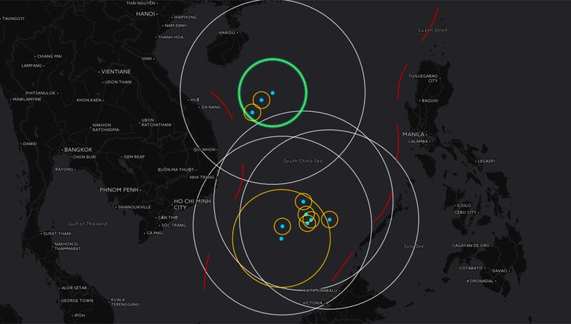
This awesome interactive map shows China’s emerging area denial and anti-access military capabilities in the South China Sea. It is useful in visually tracking China’s progress towards creating an overlapping field of control over a vast majority of the area.
The map, which you can access here, is built by the Center for Strategic and International Studies (CSIS).
Great work Tyler:One of China’s highly developed islands in the northern part of the South China Sea, Woody Island, has been equipped with surface-to-air missiles and fighter aircraft. These moves have come just as many defense analysts have predicted for years and are likely an indication of things to come for China’s other island outposts throughout the South China Sea.
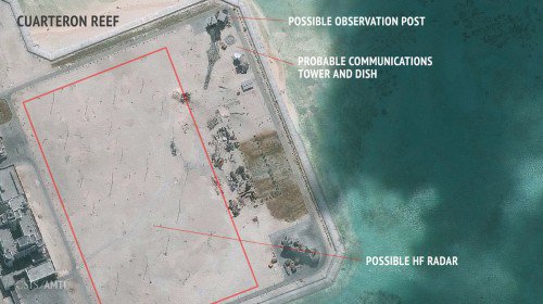
There is also evidence that China is installing a high-frequency long-range radar array on Cuarteron Reef, one of their handful of manmade islands in the south-central part of the South China Sea. This radar type is known to be used for detecting aircraft and ships at extreme ranges far over-the-horizon and can theoretically detect some stealthy aircraft under certain circumstances. It is just one of many other sensors popping up on this island and others, although the existence of such a capability provides even more evidence that China is actively seeking an aggressive anti-access, area denial strategy over the South China Sea.
China might be installing HF radar that can detect stealth aircraft in S. China Sea http://dlvr.it/KZx2T3 pic.twitter.com/EXArDvci2Q
This all comes as China’s largest island building project out of their manmade island initiative, Fiery Cross Reef, officially activated its 9,000-foot runway early last month. The runway is capable of supporting even China’s heaviest bomber and transport aircraft.
With any luck CSIS will keep updating this fabulous visual resource as China expands its military capabilities to its other islands that remain under construction in the South China Sea. Undoubtedly, the threat rings you see today will blossom and multiply, creating a massive overlapping area of control backed up by anti-ship and anti-air missiles, as well as fighter and maritime surveillance and attack aircraft.
Going back to 2015: (So much for that Obama Asia Pivot)
Analysts say the imminent end to China’s island-building work could signal a willingness to seek compromise with Washington and rival claimants in the South China Sea, even as it demonstrates Beijing’s ability to unilaterally dictate terms in the long-standing dispute.
“This is a step toward halting land reclamation, which the U.S. has demanded, and at the same time, China can tell its people that it has accomplished what it wanted to do,” said Huang Jing, an expert on Chinese foreign policy at the Lee Kuan Yew School of Public Policy in Singapore.
“China unilaterally started the land reclamation and now China is unilaterally stopping it,” Mr. Huang said. “China is showing that—as a major power—it can control escalation, that it has the initiative, and that it can do what it sees fit for its interests.”
Beijing lays claim to almost the entire South China Sea, a stretch of resource-rich waters that carries more than half the world’s trade. Its claims overlap with those of Malaysia, Vietnam, Brunei, Taiwan and the Philippines—several of whom have criticized China’s rapid and extensive construction program in the Spratlys as the latest in a series of aggressive Chinese efforts to assert territorial rights.
