This should answer many questions and it was crafted in 2014.
بسم الله الرحمن الرحيم
ACTIONS MUSLIMS SHOULD TAKE IN RESPONSE TO POLICE BRUTALITY
Toolkit on policing and police brutality calling for American Muslims leaders to join us in taking a stand, becoming more visible, and playing a more active part in addressing structural racism, and, in particular, police brutality.
Team
Author:
Margari Hill
Programming Director, Muslim Anti-Racism Collaborative
Editor:
Namira Islam
Executive Director, Muslim Anti-Racism Collaborative
Contributors
MuslimARC Programming Volunteers

www.muslimarc.org/blacklivesmatter
info@muslimarc.org
Last updated Sunday 11/1/15 9:13 am PST
TABLE OF CONTENTS
TOOLKIT
OBJECTIVES
SUGGESTED ACTIONS
LETTER TO AMERICAN MUSLIMS
TIPS FOR ORGANIZING A DIALOGUE ON BLACKLIVESMATTER IN THE MUSLIM COMMUNITY
DEFINITIONS
FACTS AND INFORMATION
STATISTICS
List of Deaths Protested by Black Lives Matter
VISUAL AIDS AND IMAGES
PROTESTER DEMANDS
Ferguson Action Demands
This Stops Today Demands
Black Lives Matter Demands
BALTIMORE DEMANDS
March 2 Justice Demands
The Young, Gifted and Black Coalition (YGB) and Freedom, Inc Demands
Campaign Zero Platform
Justice Or Else
RESOURCES
Organizations and Coalitions
Actions, Convenings, and Marches
Reports/Statements/Articles
Books
Guides, Factsheets, and Toolkits
Films
Music
Videos, Art, and Multimedia
TOOLKIT
“Ferguson is everywhere.”
Racial Prejudice + Institutional Power = Racism
OBJECTIVES
- Encourage members of Muslim communities to address police brutality, lack of police accountability, structural racism in law enforcement, militarization of police force, the school to prison pipeline, and economic inequities using strategies of faith-in-action leading to actions of solidarity
- Offer individuals and institutions methods for sustained action to address state sanctioned violence against Black bodies, over-policing, and over-incarceration of Black Americans
- Develop a national strategy for addressing institutional racism that is embedded in legal codes and structures in our society
State sanctioned violence against Black bodies, over-policing, and over-incarceration of Black Americans are emblematic of the institutional racism that is embedded in legal codes and structures in our society. The clear racial disparities and devastating effects of the prison-industrial complex on Black/African American Muslim communities demand a response from our leaders and organizers. Systemic racism not only deprives individuals of opportunities, but undermines our dignity as a people. The Black American Muslim community is not immune, as some youth are lost to the street or all but abandon their faith.
Understanding the context of the Black Lives Matter is important. In response to the acquittal of George Zimmerman of the murder of Trayvon Martin in July 2013, queer Black women activists Patrisse Fullors, Opal Tometi, and Alicia Garza created the hashtag #BlackLivesMatter as a call to action. When Darren Wilson killed Michael Brown (#HandsUpDontShoot) in the summer of 2014, the hashtag went viral. The movement expanded exponentially when Daniel Pantaleo was not indicted for killing Eric Garner (#ICantBreath) with a choke hold (See a visualization here). Law enforcement killing of Black continues to draw national attention and the list continues. Protests have spread across the country and a recent UN report
Our goal is to draw upon our Islamic traditions and historical legacy of Black upliftment and empowerment. We intend to not only raise consciousness, but to affect change in our communities. At the turn of the 21st century, we must think about the legacy we are leaving for our youth, as well as the opportunities that we need to create in order to demonstrate that Islam is relevant in their spiritual, social, and emotional lives.
Below are a list of suggested actions that individuals, organizations, and communities can take to address racism in the justice system. The hyperlinks provide examples or serve as references. We encourage you to read them to expand your knowledge and help open more possibilities. We welcome feedback and invite you to submit more suggestions and models for anti-racism actions by emailing info@muslimarc.org.
[Back to Table of Contents]
SUGGESTED ACTIONS
What You Can do as an Individual
- Pray. Either deepen your prayer for the situation, or get started now. Pray for an end to racism, police brutality, and racial injustice. If you are an imam, be sure to include communities affected by police brutality and structural racism in your du’a in the Jumu’ah prayer. Anas ibn Malik reported: The Messenger of Allah, peace and blessings be upon him, said, “Beware of the supplication of the oppressed, even if he is an unbeliever, for there is no screen between it and Allah” (Musnad Ahmad 12140).
- Learn. Identify anti-racism classes and workshops. Set aside time to read about institutional, interpersonal, and internalized racism to become well informed about structural racism, police misconduct, police surveillance, the school-to-prison pipeline, prison-industrial complex, and Communications Management Units.
- Study. Read books, watch documentaries, or take classes on Black history, the history of Black American Muslims, Black/African American culture, and/or contemporary issues.
- Listen. There are people who are feeling emotional pain and trauma from the recent events. “Racism is a Chronic and/or an Acute Stressor that Causes Trauma” (Carter, 2007). Thus, listen and ask questions in order to empathize with another’s pain and trauma. Do not control the conversation or ask folks to be “less emotional” and “more logical or objective” because this can be hurtful,offensive, and dismissive (Grollman, N.D.).
- Engage. You can make environments less toxic, educate the uninformed, support a victim of racism, and help win broader support by engaging with the issues. Engagement can consist of calling out racist discussions or correcting misconceptions in discussions with friends, family, and associates. Bystander anti-racism, a largely untapped policy resource, occurs when regular people address interpersonal or systemic racism (Grollman, N.D.)
- Amplify. Help amplify marginalized individuals. Provide meaningful opportunities for Black, Latino, and Native American brothers and sisters to share their experiences in how institutional racism has affected their lives. Help ensure that they a platform to tell their story. Learn to use whatever privileges you may have, whether it is educational, gender, race, or class privilege, and work to be a good ally (Hill, 2014).
- Avoid. Avoid actions that discourage forward movement on this cause. This includes appropriating a high profile cause simply for the appearance of giving da’awah or increasing your public profile. Check your nafs and focus on sustained action and change. Do not make the issue about your personal cause or attempt false comparisons between groups (Khan, 2014). Avoid derailing conversations about race and racial injustice, i.e. “What about Black-on-Black crime?”(Walton, 2014 ). These conversations are not relevant and undermine our efforts to tackle racism in the justice system.
- Act. There are many things you can do to make your voice heard, become more visible, and manifest your will. This includes non-violent protest, supporting protesters, marching, endorsing organizations, etc. Three major categories are as follows: nonviolent protest and persuasion, noncooperation (social, economic, and political), and non violent intervention (198 methods of Nonviolent Action).
Organize Events to Address Police Brutality and Systemic Racism
- Watch. Organize a film screening of a film or documentary that sheds light on the prison industrial complex and police brutality. Some examples include Prison Blues by Mustafa Davis; Fruitvale Station; selections from Do the Right Thing (1989); selections from Malcolm X (1992). Have a panel and Q&A session to discuss the issues raised in the film (Alvis, 2014).
- Discuss. Organize forums, discussion groups, Peace Making Circles, or safe spaces to meet and start conversations about racism. Gather resources needed to support honest engagement about police brutality with a goal of unmasking, dismantling and eradicating racism through anti-racism development.
- Speak. Encourage your leaders to teach, preach, and speak out against racism, now and on a regular basis. Organize policy-level conversations that can impact institutions and laws that affect the daily lives and opportunities of the most marginalized groups (Race Forward).
What Your Organization Can Do
- Prepare. Develop an anti-bias organizational assessment to analyze the policies and practices of your organization (ChangeWork).
- Establish. Ensure that your organization or community creates an environment of intolerance for racist conduct. Develop a clear policy statement about your organization’s zero-tolerance stance on racism. Develop clear policies and disciplinary actions towards racist speech and actions. (Dewey, 2013)
- Develop. Develop a vision and system of accountability for anti-bias policies and practices to ensure that you are achieving your goals. Create and utilize a system to back up your community’s policies towards racism. The system should allow for reporting and documenting instances of racism and provide clear details regarding the corrective action system (Chuasiriporn, N.D.)
- Form. Form partnerships with anti-racism organizations, as well as community members, families, leaders, and grassroots organizations that tackle structural racism and empower marginalized communities (NPARC).
What You Can do for Sustained Action
- Link. Join efforts with organizations that have track records in anti-racism work, civil rights, or empowering urban communities. Connect with the National Urban League, NAACP, and/or the ACLU, as well as grassroots, smaller, advocacy and community organizing agencies found throughout urban America (Khalifah)
- Organize. Become civically engaged to address police brutality, gun violence, education, health care, and employment access; join an organization working to end inequity in the U.S. Meet with organizations and groups or join an association that is committed to addressing inequity (Rabinowitz).
- Address. Address these issues on a city, state, and federal level.
- Develop. Develop a sustained civil rights agenda that confronts the most salient forms of oppression against Blacks, Latinos, and Native Americans, including the over-incarceration of Blacks and Latinos in the prison-industrial complex, economic exploitation of Blacks and Latinos, and policies that further disparities in education, health, and housing (Khalifa).
This is not an exhaustive list, but we hope they prepare us for meaningful action. We urge all Muslims to engage in today’s civil rights movement, and be on the right side of history.
If you have questions, comments, ideas or suggestions, please contact one of us. As part of our commitment to fighting racism within the Muslim community and standing for justice, we must take action. Please join us by raising your voice and standing up to say “this ends today.” [1]
[Back to Table of Contents]
LETTER TO AMERICAN MUSLIMS
Muslim Engagement in #BlackLivesMatter
To: Muslim Communities and Leaders
Our Noble Prophet ﷺ said,
”Help the oppressed and guide those who have lost their way..”
(Book 41, Number 4799: Sunan Abu-Dawud)
A verified study reports that in 2012, a Black American was shot or killed by law enforcement, vigilantes, or security guards on average every 28 hours. This statistic includes women and children. It includes the killings of Black American Muslim men Imam Luqman Ameen Abdullah and Amadou Diallo. Today, this reign of terror against Blacks continues, only to be met with unjust and defective response by our judicial systems. As a result, the tumultuous times we live in invoke strong emotions. As Muslims, we know that the Qur’an is clear in respect to the sanctity of life: “Whoever kills a soul except for a soul or grave corruption in the earth, it is just as him killing all of humankind” ( 5:32). This sanctity applies to every life and every people. Islamic adab (etiquette) is rooted in empathy, and as Blacks continue to be targeted unjustly, our responses should be empathetic. Muslim leadership should be visible in guiding our communities, and our youth in particular, in standing up for justice.
We call on Muslim community leaders to unite and take a stand for police accountability and racial justice. This is an important juncture in our history for freedom struggles. Protests are rippling across the country in response to the failure of grand juries to indict Darren Wilson in Ferguson for killing Michael Brown, Daniel Pantaleo in New York for killing Eric Garner, or Sean Williams in Ohio for killing John Crawford III. These extrajudicial killings are not isolated events. They reflect a systemic racism in which social, economic, educational, and political forces and policies foster discriminatory outcomes against Black people. Given that race is inextricably tied in with these events, we must unequivocally affirm the egalitarian nature of Islam in which the Qur’an and Sunnah clearly condemn racism not just in the form of individual actions, but as a structure that marginalizes people.
As Muslims, we should draw upon our strong tradition of standing for a just society as Allah instructs us to in the Qur’an:
“O you who have believed, be persistently standing firm in justice, witnesses for Allah, even if it be against yourselves or parents and relatives. Whether one is rich or poor, Allah is more worthy of both. So follow not [personal] inclination, lest you not be just. And if you distort [your testimony] or refuse [to give it], then indeed Allah is ever, with what you do, Acquainted“ (4:135)
Standing for justice in this country entails confronting the embedded racial inequalities of our society. As American Muslims, we must not fall into apathy, but instead put our faith into action and take a stand against oppression, whether by seeking to remove it with our hands, speaking against it, or hating it in our hearts.
As part of our work in calling upon our Islamic traditions to foster thriving communities, we ask that American Muslim leaders and organizations be part of the solution. The Prophet Muhammad ﷺ is introduced in the Qur’an, “And We have not sent you forth but as a mercy to mankind” (21:107). As a community, we must help create the conditions to restore the dignity and human potential to our people.
Allah tells us in the Qur’an, “Indeed, Allah will not change the condition of a people until they change what is in themselves” (13:11). This includes commitments for moral reform and social change. Given this moral imperative, American Muslims must take the lead in addressing the broader forces in society that disempower Black communities in general, and our communities in particular. We are calling on our brothers and sisters to stand, speak, and act.
You can endorse the #CallforJustice letter to show your support for #BlackLivesMatter. A list of suggested actions, as well as infographics, statistics, and lists of resources, for individuals, organizations, and communities to utilize in their work to address racial injustices is located at www.muslimarc.org/blacklivesmatter in the MuslimARC Toolkit.
The Undersigned:
Margari HIll, Programming Director MuslimARC
Namira Islam, Executive Director, MuslimARC
Su’ad Abdul Khabeer
[Back to Table of Contents]
TIPS FOR ORGANIZING A DIALOGUE ON BLACKLIVESMATTER IN THE MUSLIM COMMUNITY
This guide aims to provide some general tips for organizing a dialogue/discussion group on Black Lives Matter in Muslim communities. Why a dialogue? At MuslimARC, we believe in the power of storytelling and dialogue in learning. J.K. Vella (1997) writes, “The simplest definition for the word “dialogue” is a two-way communicative process, a conversation or social discourse between two or more individuals. The basic assumption is that learning occurs when two people exchange thoughts, ideas, and words through dialogue (p.3). By sharing stories, experiences, and viewpoints, participants can engage with the issues and each other in a meaningful way. Our hope is that participants utilize the knowledge they gain through dialogue to work towards bringing about racial equity in Muslim communities and our society.
We encourage Muslims to organize dialogues on college campuses, mosques, community centers, third spaces, and/or in homes. We also hope that these conversations continue over coffee, meals, and in our personal exchanges. While there are many secular and faith based organizations who have organized forums around Black Lives Matter, there is little documentation of community forums aimed at equipping Muslim community members with the tools to effectively engage with the issues of police brutality, the over policing of black communities, and the militarization of American policing. Our joint “Call for Justice letter with Muslims 4 Ferguson indicate increased support within our communities for #BlackLivesMatter. Now, is the time to turn that support into sustained action and organizing to support justice and racial equity. Please let us know if you have planned or plan to organize an event. We would love to amplify your efforts and share your event as a model for others. We welcome educators, community leaders, and general community members to share their lesson plans and discussion questions with us at info@muslimARC org.
SOME TALKING POINTS
Standing Up for Justice in Law Enforcement
- Allah instructs us in the Qur’an: “O you who have believed, be persistently standing firm in justice, witnesses for Allah, even if it be against yourselves or parents and relatives. Whether one is rich or poor, Allah is more worthy of both. So follow not [personal] inclination, lest you not be just. And if you distort [your testimony] or refuse [to give it], then indeed Allah is ever, with what you do, Acquainted“ (4:135)
- The Qur’an is clear in respect to the sanctity of life: “Whoever kills a soul except for a soul or grave corruption in the earth, it is just as him killing all of humankind” ( 5:32).
- On the authority of Abu Saeed al-Khudri (may Allah be pleased with him), Prophet Muhammad ﷺ said: “Whoever of you sees a wrong must then change it with his hand. If he is not able to do so, then [he must change it] with his tongue. And if he is not able to do so, then [he must change it] with his heart. And that is the slightest [effect of] faith.” (Recorded in Muslim)
Addressing Systemic Racism
- Over policing and police brutality reflect a systemic racism in which social, economic, educational, and political forces and policies foster discriminatory outcomes against Black people (see statistics in #BlackLivesMatter toolkit).
- Given that race is inextricably tied in with these events, we must unequivocally affirm the egalitarian nature of Islam in which the Qur’an and Sunnah clearly condemn racism not just in the form of individual actions, but as a structure that marginalizes people.
- We must stand, speak, and act to support racial justice.
Commonalities and Shared Futures
- Just as many Muslims decry the use of drones and armed warfare against civilians abroad, we must take a stand against state violence against civilian populations here at home.
- We must avoid drawing the false binary that makes police brutality a Black issue and surveillance a Muslim issue because a significant 25-30% of Muslim Americans are both Black and Muslim. As such, Allah reminds us in the Qur’an: “The believing men and believing women are allies of one another. They enjoin what is right and forbid what is wrong and establish prayer and give zakah and obey Allah and His Messenger. Those – Allah will have mercy upon them. Indeed, Allah is Exalted in Might and Wise” [Qur’an 9:71]. There are Black/African American Muslims who are affected by these issues and have been working to address them. We must support them, as well as interfaith and secular coalitions.
- We must stand with the oppressed and marginalized as our liberation is intrinsically linked.
Today’s Issues Have Continuity with Civil Rights Struggle
- We can never be satisfied as long as the Negro is the victim of the unspeakable horrors of police brutality.” Martin Luther King 1963 (From the I have a dream speech).
- “The police commissioner feeds the type of statistics to the white public to make them think that Harlem is a complete criminal area where everyone is prone towards violence. This gives the police the impression that they can then go and brutalize the Negroes, or suppress the Negroes, or even frighten the Negroes.” Malcolm X interview with Mike Wallace June 8, 1964
TIPS FOR A SUCCESSFUL DIALOGUE
- Sometimes community dialogues can be so intense and emotionally triggering that they can generate a sense of hopelessness in members of oppressed communities or they can foster naval gazing amongst the more privileged. One way to overcome this is to look for solutions. One way to frame the dialogue is to have activities that allow participants to create action items or asks from the community/legislators/law enforcement
- Encourage participants to stretch outside their comfort zone and build relationships and coalitions with others from different ethnic/religious/socio-economic backgrounds
- In diverse groups, encourage participants to look for commonalities and shared histories. For example ask participants from immigrant backgrounds to reflect on the oppression their communities have historically experienced abroad and in the U.S., such as colonialism, authoritarian regimes, police states, surveillance, disrimination, and neo-colonialism.
- Begin with a short introductory lecture that lays out ground rules and provides baseline information. See #BlackLivesMatter Toolkit for Muslims for resources. If you have trouble developing introductory material, email info@muslimarc.org.
- There are many ways to encourage participation For example have a large group break into smaller groups for small group discussion, have each participant write out their thoughts and then read them to their group, You can increase participation by asking all participants to first write out their thoughts and then read them.
- Be clear about the goals for the dialogue, then develop discussion prompts and activities to foster those goals. Is it to create a safe space for healing? Is it to mobilize the community? Is it to develop a task force? Is it to develop an action plan.
SAMPLE OBJECTIVES
1. Participants will be able to summarize the issues that have led to uprisings and nation-wide protests against police brutality and list common demands by grassroots organizers
2. Participants will be able to reflect on their own privilege/oppression and how it shapes their approach to police brutality and communities affected by police brutality and racial profiling
3. Participants will be able to outline the Islamic ethos of anti-racism work and discuss ways strive towards racial equity and solidarity with oppressed communities most affected by over policing and police brutality.
SAMPLE GROUND RULES
- “One Mic” (no interruptions);
- Use “I” instead of “We” statements (speaking from experiences rather than generalizing);
- Be conscious of how much space people are taking up;
- Challenge ideas and not people;
- Understanding the difference between feeling uncomfortable and feeling unsafe; this is difficult topic and for some it may be triggering. Allow people who feel overwhelmed to leave the room for a breather.
- Ask participants to make a list of agreed upon ground rules the entire group feels comfortable with.
SAMPLE DISCUSSION QUESTIONS
- What are your personal connections to this issue and any elements, facts or other things which you think are really important to consider?
- What are some initiatives/programs that members of the Muslim community can support?
- How can we be better advocates/allies/supporters for the oppressed in this society?
- The Ferguson Action Team have names this the #BlackSpring. Can you draw some comparisons with global revolutions?
- Are there any comparisons to the policing of Black and brown communities and surveillance of Muslim communities? Where are the overlaps?
SOURCES
Community Dialogue Guide http://www.justice.gov/archive/crs/pubs/dialogueguide.pdf
J.K. Vella Learning to list, learning to teach: The power of dialogue in educating adults. San Francisco: Jossey-bass, 1997, p.3).
[Back to Table of Contents]
DEFINITIONS
Discrimination: the practice of unfairly treating a person or group of people differently from other people or groups of people.
Ethnicity: A group of people with common traits, background, and associations. Refers to cultural background (i.e., language, food, and style of clothing).
Institutional racism: Institutional policies and practices that creates advantages for privileged race(s) and disadvantages for others, resulting in different outcomes for different racial groups.
Race: A group of people related in a common descent or ancestry often linked to phenotype (i.e. skin color, hair texture, facial features)
Racism: The systematic unequal distribution of rights, privileges, resources, and protections along racial lines and the assignment of worth, ability, and value according to race.
Shadeism: Discrimination against individuals based on skin tone, often considered synonymous with colorism (q.v.). Shadeism can occur within communities of color and often takes the form of preference for lighter skin tones.
Systemic Racism: Discrimination built into the way organizations and governments operate. This often involves informal activities and cultures.
[Back to Table of Contents]
FACTS AND INFORMATION
STATISTICS
“A Bureau of Justice Statistics report in 2008 found that black people were almost three times more likely than white people to be subjected to force or threatened with it by police.” (Marc Robinson, 2014)
“The 1,217 deadly police shootings from 2010 to 2012 captured in the federal data show that blacks, age 15 to 19, were killed at a rate of 31.17 per million, while just 1.47 per million white males in that age” (Gabrielson, Jones, Sagara, 2014)
“…Young black men are 21 times as likely as their white peers to be killed by police…” (Gabrielson, Jones, Sagara, 2014)
“Prison sentences of black men were nearly 20% longer than those of white men for similar crimes in recent years, an analysis by the U.S. Sentencing Commission found”(JOE PALAZZOLO, 2013).
“For Black males in their thirties, 1 in every 10 is in prison or jail on any given day” (Sentencing Project, N.D.).
“Although there are no reliable statistics, estimates suggest that 35,000-40,000 inmates convert to Islam each year, and nationwide, it is estimated that 15 percent of the U.S. prison population is Muslim, or as much as 350,000 current Muslim inmates” (SpearIt, 2013).
“The national rate of unemployment for whites is 4.7% percent, for blacks it is 10.1%” (Bill Quigly, 2015).
List of Deaths Protested by Black Lives Matter
(In Alphabetical Order- This list is largely from BlackLivesMatter Wikipedia Entry)
May 16, 2010
Aiyana Jones (7)
Detroit, Michigan
Shot by policeman Joseph Weekley during a house raid. Weekley was ultimately cleared of all charges after multiple mistrials.
November 20, 2014
Akai Gurley (28)
Brooklyn, New York
Shot by policeman Peter Liang, who drew his gun and accidentally discharged it. A round ricocheted and hit Gurley, who was elsewhere on the same stairwell as Liang. Liang was indicted by a grand jury on manslaughter, assault, and other criminal charges.[79]
December 23, 2014
Antonio Martin (18)
Berkeley, Missouri
Shot by an unidentified white police officer after Martin pulled a gun on him while the officer was responding to a shoplifting report at a convenience store.
December 15, 2014
Brandon Tate-Brown
Philadelphia, PA
Two officers stopped Brandon Tate-Brown for driving without headlights. Officers claim they saw a gun in the car’s middle console. A struggle ensued where Tate-Brown was shot in the head. Police originally said that Tate-Brown was reaching into the car for the loaded weapon then conceded, with video evidence to support that he was running around the back of the car when the officer fired.
April 30, 2014
Dontre Hamilton (31)
Milwaukee, Wisconsin
Shot by policeman Christopher Manney, when a fight broke out when Manney attempted to frisk Hamilton. Although he did not face criminal charges, Manney was fired from the police.
June 17, 2015
Emanuel Nine (multiple)
Charleston, South Carolina
A mass shooting, allegedly by Dylann Roof, at the Emanuel African Methodist Episcopal Church resulted in nine dead and one injured.
July 17, 2014
Eric Garner (43)
New York City, New York
Died from a chokehold by policeman Daniel Pantaleo as well as the police’s compression of Garner’s chest. Garner was being arrested on the suspicion of selling untaxed cigarettes.
August 11, 2014
Ezell Ford (25)
Florence, Los Angeles
Shot by policemen Sharlton Wampler and Antonio Villegas, who confronted Ford as part of an “investigative stop”.
April 12, 2015
Freddie Gray (25)
Baltimore, Maryland
Fell into a coma while being transported by police after they arrested him. Gray died a week later of injuries to his spinal cord. Charges have been filed against six policemen after a medical examiner’s report that ruled Gray’s death a homicide.
Resulted in the 2015 Baltimore protests.
September, 23, 2015
Jeremy McDole, 28
Wilmington, Delaware,
Mcdole was a 28 year old paraplegic who was shot and killed by police officers. Local bystanders have insisted that he was unarmed, and the NAACP has called for an more an investigation into the shooting.
August 5, 2014
John Crawford III (22)
Dayton, Ohio
Shot by policeman Sean Williams when police answered a 911 call alleging a man waving a gun in a Walmart store. Crawford was holding a pellet/BB gun being sold in the store itself. A grand jury declined to indict any policemen, but the United States Department of Justice is investigating.
November 23, 2012
Jordan Davis (17)
Jacksonville, Florida
Shot by software developer Michael David Dunn over an argument over loud music. Dunn was found guilty of first-degree murder and sentenced to life in prison without parole.
November 19, 2011
Kenneth Chamberlain, Sr. (68)
White Plains, New York
Shot by policeman Anthony Carelli in Chamberlain’s home. No criminal charges filed. Emergency services were drawn to Chamberlain’s home after his medical alert device activated. Chamberlain refused to let them in, with police breaking down the door to enter.
August 19, 2015
Mansur Ball-Bey (19)
St. Louis, Missouri
Mansur Ball-Bey was shot and killed while fleeing officers who were executing a warrant.
March 28, 2015
Meagan Hockaday (26)
Oxnard, California
Shot by policeman Roger Garcia after Hockaday ran at Garcia and his partner with a knife while they were responding to a domestic dispute report. Garcia has been placed on administrative leave and the case is currently being investigated.
August 9, 2014
Michael Brown (18)
Ferguson, Missouri
Shot by policeman Darren Wilson on a street. After Brown robbed a convenience store, he was confronted by Officer Wilson. The two struggled through the window of Wilson’s police vehicle, where Wilson shot Brown, who fled with Wilson pursuing. When Brown turned around and advanced on Wilson, Wilson shot Brown multiple times in the front. Both a St. Louis County grand jury and the United States Department of Justice decided not to charge Wilson.
Resulted in several waves of the Ferguson unrest, as well as the “Hands up, don’t shoot” saying.
November 29, 2012
Multiple:
Timothy Russell (43)
Malissa Williams (30)
Cleveland, Ohio
Both were shot during a car chase, each being hit more than 20 times. 13 policemen fired 137 shots into the car; the car chase stemmed from police thinking they were being shot at by the car’s occupants, but no gun was found in the car and the sound was later determined to be due to the back-fire of the Chevrolet Malibu. Policeman Michael Brelo was charged with voluntary manslaughter, but was cleared in 2014. The judge found that because other policemen had also fired, it was not beyond reasonable doubt Brelo was responsible for killing the duo.
March 2012
Rekia Boyd (22)
Chicago, Illinois
Shot by policeman Dante Servin after Servin confronted a group of people in a local park. A directed verdict found Servin not guilty of involuntary manslaughter.
November 2, 2013
Renisha McBride (19)
Dearborn Heights, Michigan
Shot by airport maintenance worker Theodore Wafer, after McBride had approached Wafer’s home on a rainy early morning after a car accident, seeking help. Wafer was sentenced to at least 17 years in jail for second-degree murder, manslaughter and felony firearm usage.
July 19, 2015
Samuel DuBose (43)
Cincinnati, Ohio
Shot by University of Cincinnati police officer Ray Tensing during a traffic stop when DuBose failed to step out of his vehicle and may have attempted to drive off.Tensing has been charged with murder.
July 13, 2015
Sandra Bland (28)
Waller County, Texas
Pulled over by police, arrested, and found dead in her jail cell. Her death was ruled a suicide by the county medical examiner, with no evidence of foul play.
November 22, 2014
Tamir Rice (12)
Cleveland, Ohio
Shot in a city park by policeman Timothy Loehmann. Rice had been allegedly pointing his air-soft pellet gun replica at passersby prior to getting shot. A grand jury will decide whether either Loehmann or his partner Garmback will be indicted.
March 6, 2015
Tony Robinson (19)
Madison, Wisconsin
Shot by policeman Matt Kenny during an altercation as Kenny was responding to reports of a man jumping in front of cars and attempting to strangle someone. The Wisconsin Department of Justice will investigate the Robinson shooting.
February 26, 2012
Trayvon Martin (17)
Sanford, Florida
Trayvon Martin was shot outdoors by neighborhood watch coordinator George Zimmerman, who was later charged and acquitted of second-degree murder and manslaughter.
Resulted in the speech “Trayvon Martin could have been me 35 years ago” by President Barack Obama.
Directly inspired the beginning of the Black Lives Matter movement.
April 4, 2015
Walter Scott (50)
North Charleston, South Carolina
Shot by police officer Michael Slager during a traffic stop. Slager was charged with murder after a video surfaced showing him shooting Scott multiple times from behind while Scott was fleeing.
[Back to Table of Contents]
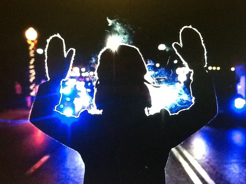
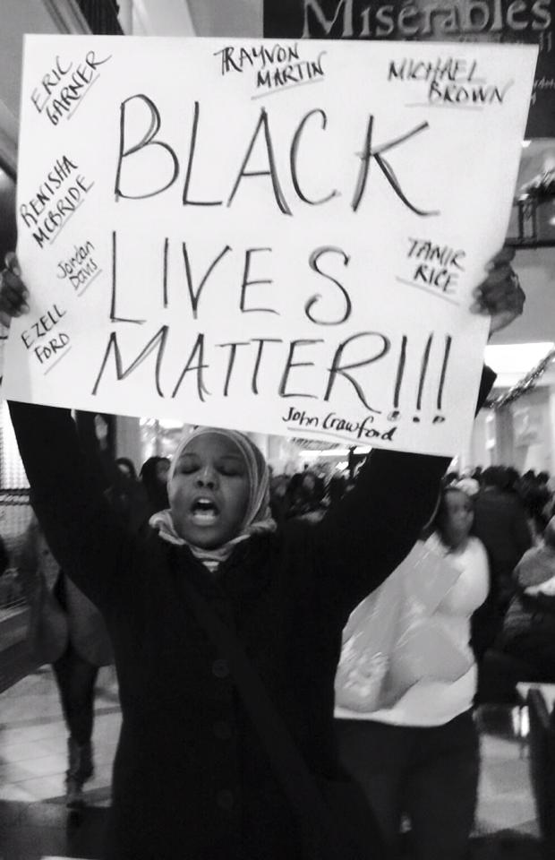
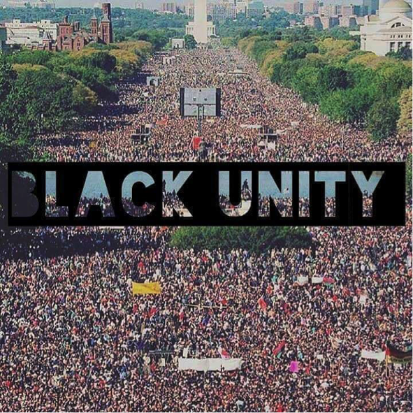
VISUAL AIDS AND IMAGES
|

[Taqwa Brookins leading Rutgers Protest]
|
[Yasmin Qaddoumi, shortly before her arrest during Ferguson protests 11/25/14 Image source AFP]
|
|

[Image Source: Dawud Walid]
|
[Kameelah Mu’min Rashad King of Prussia Die In 12/20/14]
|
|
|
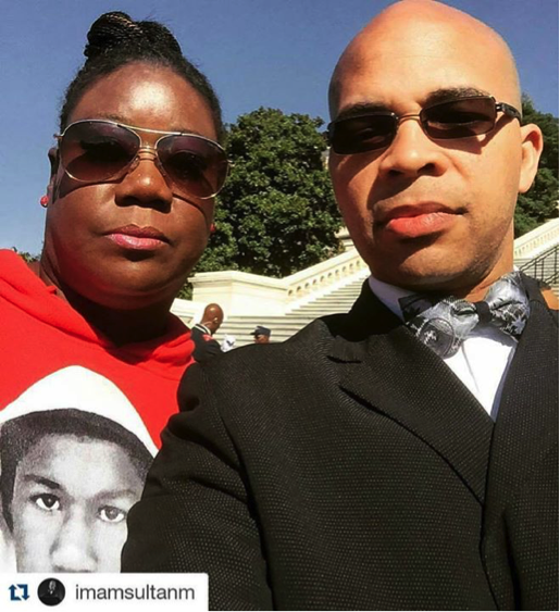
Sybrina Fulton, Travyton Martin’s mother with Imam Sultan Muhammad, national Imam of the Nation of Islam
|
|
|

|
[Back to Table of Contents]
PROTESTER DEMANDS
Ferguson Action Demands
(http://fergusonaction.com/demands/)
OUR VISION FOR A NEW AMERICA
WE WANT JUSTICE FOR MICHAEL BROWN.
WE WANT FREEDOM FOR OUR COMMUNITIES.
We Want an End to all Forms of Discrimination and the Full Recognition of our Human Rights
The United States Government must acknowledge and address the structural violence and institutional discrimination that continues to imprison our communities either in a life of poverty and/or one behind bars. We want the United States Government to recognize the full spectrum of our human rights and its obligations under international law.
We Want An Immediate End To Police Brutality And the Murder Of Black, Brown & All Oppressed People
Every 28 hours a black person in the United States is killed by someone employed or protected by the government of the United States. Other communities are also criminalized, targeted, attacked and brutalized. We want an immediate end to state sanctioned violence against our communities.
We Want Full Employment For Our People
Every individual has the human right to employment and a living wage. Inability to access employment and fair pay continues to marginalize our communities, ready us for imprisonment, and deny us of our right to a life with dignity.
We Want Decent Housing Fit For The Shelter Of Human Beings
Our communities have a human right to access quality housing that protects our families and allows for our children to be free from harm.
We Want an End to the School to Prison Pipeline & Quality Education for All
We want an end to policies that criminalize our young people as well as discriminatory discipline practices that bar access to quality education. Furthermore, we want all children to be able to access free, quality education. Including free or affordable public university.
We Want Freedom from Mass Incarceration and an End to the Prison Industrial Complex
We want an end to the over policing and surveillance of our communities. This will hasten an end to the criminalization of black and brown people and hyper incarceration everywhere. Policing in the United States has historically helped to enforce racist laws, policies and norms. The result is a massive prison industrial complex built on the warehousing of black people. We call for the cessation of mass incarceration and the eradication of the prison industrial complex all together. In its place we will address harm and conflict in our communities through community based, restorative solutions.
National Demands
- The De-militarization of Local Law Enforcement across the country
Strict limits on the transfer and use of military equipment to local law enforcement and the adoption of the Stop Militarizing Law Enforcement Act of 2014. The federal government should discontinue the supply of military weaponry and equipment to local law enforcement and immediately demilitarize local law enforcement, including eliminating the use of military technology and equipment.
- A Comprehensive Review of systemic abuses by local police departments, including the publication of data relating to racially biased policing, and the development of best practices.
A comprehensive review by the Department of Justice into systematic abuses by police departments and the development of specific use of force standards and accompanying recommendations for police training, community involvement and oversight strategies and standards for independent investigatory/disciplinary mechanisms when excessive force is used. These standards must include a Department of Justice review trigger when continued excessive use of force occurs.
A comprehensive federal review of police departments’ data collection practices and the development of a new comprehensive data collection system that allows for annual reporting of data on the rates of stops, frisks, searches, summonses and arrests by race, age, and gender.
These standards must also include a DOJ review trigger when departments continue discriminatory policing practices.
- Repurposing of law enforcement funds to support community based alternatives to incarceration and the conditioning of DOJ funding on the ending of discriminatory policing and the adoption of DOJ best practices
The repurposing of Department of Justice funds to create grants that support and implement community oversight mechanisms and community based alternatives to law enforcement and incarceration—including community boards/commissions, restorative justice practices, amnesty programs to clear open warrants, and know-your-rights-education conducted by community members.
The development of a DOJ policy to withhold funds from local police departments who engage in discriminatory policing practices and condition federal grant funds on the adoption of recommended DOJ trainings, community involvement and oversight strategies, use of force standards and standards for independent investigatory/disciplinary mechanisms.
- A Congressional Hearing investigating the criminalization of communities of color, racial profiling, police abuses and torture by law enforcement
Congressional hearings investigating the criminalization of communities of color and systemic law enforcement discriminatory profiling and other abuses especially at the local level—including an examination of systemic structures and institutional practices and the elevation of the experiences and voices of those most impacted. Congressional hearings will allow for a continuation of the national discussion about police abuse and it’s underlying causes.
- Support the Passage of the End Racial Profiling Act
Support for the passage of the End Racial Profiling Act (ERPA) which in law would prohibit the use of profiling on the basis of race, ethnicity, national origin or religion by law enforcement agencies.
- The Obama Administration develops, legislates and enacts a National Plan of Action for Racial Justice
The development and enactment of a National Plan of Action for Racial Justice by the Obama Administration. The National Plan of Action for Racial Justice should be a comprehensive plan that address persistent and ongoing forms of racial discrimination and disparities that exist in nearly every sphere of life including: criminal justice, employment, housing, education, health, land/property, voting, poverty and immigration. The Plan would set concrete targets for achieving racial equality and reducing racial disparities and create new tools for holding government accountable to meeting targets.
This Stops Today Demands
(http://www.thisstopstoday.org/demands/)
ACCOUNTABILITY FOR NYPD USE OF EXCESSIVE & DEADLY FORCE, AS WELL AS ABUSE
1) Full accountability through NYPD disciplinary procedures and the criminal justice system for all NYPD officers responsible for killing Eric Garner, Akai Gurley and all officers who brutalize New Yorkers.
2) Department of Justice should convene grand juries to federally indict officers responsible for the killing of Eric Garner, as well as in other NYC cases such as Ramarley Graham. (We are in solidarity with calls for federal charges in the killings of Michael Brown, John Crawford and others).
3) Governor Cuomo should issue an executive order directing the Office of the Attorney General to serve as special prosecutor in cases involving civilians killed by police officers.
4) Governor Cuomo should veto legislation (S7801/A9853) that would allow police unions to make police disciplinary policies subject to contract negotiations. The legislation would undermine the ability of local government officials across New York State to discipline officers engaged in misconduct and brutality.
5) End the NYPD Commissioner’s exclusive authority over disciplinary decisions for officers in cases of abuse, misconduct towards civilians, and excessive or deadly force.
END DISCRIMINATORY AND ABUSIVE NYPD POLICIES & PRACTICES
6) Mayor de Blasio should end broken windows, and other discriminatory and abusive policing practices. This includes hyper-aggressive selective enforcement of low-level offenses, NYPD’s discriminatory arrests for violations (non-criminal offenses), enforcement of possession of small amounts of marijuana; blanket surveillance of Muslim communities and political activists.
7) Mayor de Blasio should work with the City Council to pass the Right to Know Act to protect New Yorkers’ rights and improve daily interactions between NYPD officers and New Yorkers.
8) The Floyd federal stop-and-frisk trial court-appointed monitor Peter Zimroth, the facilitator Judge Ariel Belen, and Mayor Bill de Blasio should ensure that organizations led by and for communities impacted by discriminatory and abusive policing have a formal and structured role in NYPD reform. The Court-appointed Monitor, Facilitator and Mayor’s office should work with Communities United for Police Reform (CPR) to ensure that community organizations help determine what reforms are to be implemented, how they should be implemented, and how they are evaluated.
TRANSPARENCY OF NYPD DISCRIMINATORY ENFORCEMENT AND USE OF EXCESSIVE & DEADLY FORCE
9) The Department of Justice should launch an investigation into broken windows policing and the use-of-force policies and practices of the NYPD.
10) NYPD Inspector General Philip Eure should issue a report on the use of deadly force and other excessive force, to include accounting of the disciplinary outcomes in these incidents over the past two decades.
11) The NYPD should publish quarterly and annual reports of summons and misdemeanor arrests, as well as use of force, to include demographic data such as race, gender, age, precinct, etc. (We are also in solidarity with national calls for a federal database on use of force and police killings).
- We will seek justice for Brown’s family by petitioning for the immediate arrest of officer Darren Wilson and the dismissal of county prosecutor Robert McCullough. Groups that are part of the local Hands Up Don’t Shoot Coalition have already called for Wilson’s swift arrest, and some BLM riders also canvassed McCullough’s neighborhood as a way of raising the public’s awareness of the case.
- We will help develop a network of organizations and advocates to form a national policy specifically aimed at redressing the systemic pattern of anti-black law enforcement violence in the US. The Justice Department’s new investigation into St Louis-area police departments is a good start, but it’s not enough. Our ride was endorsed by a few dozen local, regional and national organizations across the country – like the National Organization for Women (Now) and Race Forward: The Center for Racial Justice Innovation – who, while maintaining different missions, have demonstrated unprecedented solidarity in response to anti-black police violence. We hope to encourage more organizations to endorse and participate in a network with a renewed purpose of conceptualizing policy recommendations.
- We will also demand, through the network, that the federal government discontinue its supply of military weaponry and equipment to local law enforcement. And though Congress seems to finally be considering measures in this regard, it remains essential to monitor the demilitarization processes and the corporate sectors that financially benefit from the sale of military tools to police.
- We will call on the office of US attorney general Eric Holder to release the names of all officers involved in killing black people within the last five years, both while on patrol and in custody, so they can be brought to justice – if they haven’t already.
- And we will advocate for a decrease in law-enforcement spending at the local, state and federal levels and a reinvestment of that budgeted money into the black communities most devastated by poverty in order to create jobs, housing and schools. This money should be redirected to those federal departments charged with providing employment, housing and educational services.
BALTIMORE DEMANDS
Message from the Baltimore Grassroots:
WE DEMAND JUSTICE FOR FREDDIE GRAY AND POLICE ACCOUNTABILITY
SUMMARY:
The Maryland Law Enforcement Officer’s Bill of Rights (LEBOR) is the biggest obstacle to meaningful police accountability and transparency in Baltimore and around the state of Maryland. It creates barriers to gaining access to information about incidents of police misconduct/excessive force and impedes the public ability to punish officers who have abused and brutalized people in our community.
Many elected officials have made the statement that Maryland/Baltimore is not Ferguson. According to a recent report by the ALCU, 109 people have died in police custody since 2010. This is a damning refutation of a such an ignorant assertion. This has been happening for decades, but the community has had enough.
Public Safety is a public good. Public goods must be preserved through mechanisms of accountability to the institutions that are responsible for serving the community. The LEOBR keeps police from being accountable.
DEMANDS:
1) The State’s Attorney needs to do a thorough investigation and indict the officers responsible for the death of Freddie Gray.
2) All local officials must make a public commitments to substantively support efforts to move relevant reforms to the Law Enforcement Officer’s Bill of Rights during the 2016 MD Legislative session. (see attached for specified amendments). 3) A series of public mediated conversations with those who have been advocating police reform and the Fraternal Order of Police and other relevant parties.
WHY BALTIMORE IS DIFFERENT
Baltimore is saturated with non-profit institutions and controlled by the Democratic Party. These institutions engage in the practice of lifting up examples of the success of individual Black people as a sign of the collective empowerment of Black people.
This has led to a divestment in the development of independent Black led grassroots organizations. This has devastated our ability to effectively address these kinds of problems. Many of our elected officials are products of this system and have no real accountability to the masses of people in Baltimore.
We must use this opportunity to talk about building the institutional capacity, political and economic power to make our government respect our humanity. American civil society has demonstrated its lack of interest the humanity of our people, so we must build the institutions the protect our interest ourselves.
Even though we have come together to address the issue of police brutality, this is one element of a larger system of racism/white supremacy. Civil society is structured in such a way that undermines the humanity of Black people and other people of color. We need to begin to ground our words and action into sustainable mechanism for true empowerment.
We need to build the economic and political infrastructure in our communities so that we can have the capacity to build the power necessary to prevent tragedies like this from ever happening again.
THE PARTS OF THE LEOBR THAT WE WANT CHANGED
Investigations into police misconduct
CURRENT LAW: Only sworn law enforcement or a designee by the Governor or the Attorney General (or a designee of theirs) can investigate police misconduct.
DEMAND: We want people other than law enforcement to be able to be involved in investigating police misconduct. We need to allow for non-law enforcement agencies to conduct investigations as well.
• This is consistent with the recent recommendations from the US Federal Department of Justice to the Philadelphia Police Department in wake of events of police brutality in their department. 1
Police trial boards
CURRENT LAW: The only people that serve on the Police Trial Boards (which is responsible for making determinations about disciplining officers) are other Law Enforcement officials. Also, the current police trial board in Baltimore has NO citizen representative.
DEMAND: We want non-law enforcement residents to serve on police trial boards.
• This is consistent with the recent recommendations from the US Federal Department of Justice to the Philadelphia Police Department in wake of events of police brutality in their department. 2
Complaint filing with the police department
CURRENT LAW: Victims of police brutality only have 90 days to file a complaint.
DEMAND: We want to extend the amount of time that people can file a complaint to at least 180 days.
Abolish the 10 Day Rule
CURRENT LAW: Police Officers are entitled to a copy of their investigatory file 10 days before they appear before the hearing board.
DEMAND: Police officers should not receive information about the case made against them before the hearing.
1 47.3 – The police commissioner should enter into a memorandum of understanding with an external, independent investigative agency, through which the investigation of all OISs involving an unarmed person will be submitted for review.
2 40.3 – Voting board members should include command staff, a sworn officer one rank higher than the involved officer, a peer officer, and at least one citizen representative.
source: http://baltimoreuprising.org
March 2 Justice Demands
One of the most important aspects of the #MARCH2JUSTICE will be the opportunity to raise our collective voices and mobilize support in communities and Congress towards passage of what we are calling the “JUSTICE PACKAGE”.
The “Justice Package” is 3 pieces of federal legislation:
- Juvenile Justice And Delinquency Prevention Act (JJDPA)
- The End Racial Profiling Act
- Stop Militarizing Law Enforcement Act
Below please find more information about each of these legislative imperatives we support.
JUVENILE JUSTICE AND DELINQUENCY PREVENTION ACT (JJDPA): (Protecting Children and Providing for Our Communities.) The JJDPA creates a federal-state partnership for the administration of juvenile justice and delinquency prevention by providing: a juvenile justice planning and advisory system, and a federal funding plan for delinquency prevention and improvements in state and local juvenile justice programs. The JJDPA also sets forth federal standards to ensure a minimum level of safety and equitable treatment for youth who come into contact with the juvenile justice system. For messaging, videos and other educational materials: MORE HERE
END RACIAL PROFILING ACT: (The End Racial Profiling Act (ERPA)) (H.R. 2851), would prohibit the use of profiling on the basis of race, ethnicity, national origin or religion by law enforcement agencies. MORE HERE
MILITARIZATION BILL: (Stop Militarizing Law Enforcement Act) (H.R. 5478) – Amends the program under which the Secretary of Defense is authorized to transfer excess personal property of the Department of Defense (DOD) to federal and state agencies for law enforcement activities. Excludes counter-drug activities from the categories of law enforcement activities for which DOD property may be transferred under such program. The legislation lays out a number of changes to current law, and details can be found HERE
[Back to Table of Contents]
The Young, Gifted and Black Coalition (YGB) and Freedom, Inc Demands
The Young, Gifted and Black Coalition (YGB) and Freedom, Inc. denounce the non-indictment decision and renew the call to grow the Black Liberation Movement with the following demands and actions:
1). Free the 350
Blacks make up just 6% of the general population in Dane County, WI, but almost 50% of jail inmates. This disparity demonstrates structural racism. Because of the Black poverty rate, many people sit in pre-trial detention- while they are still presumed innocent- merely because they cannot pay bail of $1,000 or less. Because anyone with bail as low as $1,000 does not represent a public safety threat, those human beings are in jail because they are Black and poor. If Matt Kenny, who killed a 19 year old, did not go to jail, then no one should. Therefore, we demand the release of 350 Black inmates to end the racial disparity of incarceration.
2). Independent Investigation
We demand a dual track independent investigation into the murder of Tony Robinson and the persistent racial disparities in poverty, education, housing, public services, incarceration and policing. Because the US Department of Justice has proven incapable of bringing justice to Black communities, we demand the independent investigations are conducted entirely by the human rights bodies in the United Nations and Organization of American States.
3). Community Control Over Police
In Black communities across the country, the police serve as an occupying force. We can never expect fair or just treatment from an occupying force. Therefore, we demand full Community Control Over Police, with the power to set priorities, policies and enforce the proper practice of those mandates. We do not want a review board or community policing, but Community Control Over Police.
[Back to Table of Contents]
Campaign Zero Platform
We can live in a world where the police don’t kill people by limiting police interventions, improving community interactions, and ensuring accountability. The categories for policy solutions are as follows:
- End broken windows policing
- Community oversight
- Limit use of force
- Independently investigate and prosecute
- Community representation
- Body cams/ film the police
- Training
- End for profit policing
- Demilitarization
- Fair police union contracts
Click here to access the PDF with the full federal policy agenda
Click here to access the PDF with the full state policy agenda
Click here to access the PDF with the full local policy agenda
[Back to Table of Contents]
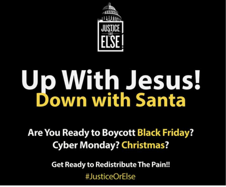
Justice Or Else
by Hakeem Muhammad
A gathering demanding #JusticeOrElse took place outside the White House on October, 10th, 2015—the 20th anniversary of the Million Man March. The ultimate demand #JusticeOrelse came as a response to the ubiquitous cases of anti-black police violence, the disproportionate concentration of poverty in black communities, and a collective white power structure that devalues the life of black people.
In attendance was Sybrina Fulton, the mother of Travyon Martin, the family of Sandra Bland, Louis Head, the step-father of Michael Brown, as well as a plethora of organizations demanding justice. This included the Nation of Islam, Black Lives Matter, and Justice League. Tamika Mallory, an organizer of the event , called for the end of police tyranny against black people,”Twenty years ago, the death of Tamir Rice would have fallen on deaf ears and been left for the police to write a false report, not broadcast for the world to know.” However, in the 20th anniversary of the Million Man March, a world of black people came together stating they had enough, they exposed police misconduct, made their demands, and boldly declared #Orelse.
The #ORELSE
As result of systemic political terrorism in black communities and other social problems which emanate from a system of global white supremacy, NOI spokesman Nuri Muhammad spoke of an appalling sociological reality, “the black male is dying at the rate of an endangered species.” These are conditions that exists in black communities that necessities the #ORELSE,– as the social situation in black communities are so unbearable that they demand immediate change. These below are all courses of action that #JusticeorElse advocates plan to take if their demands are not met.
1) Economic Withdrawal:
Protestors at #JusticeorElse called for an economic withdrawal in form of a boycott of major corporations. This tactic of economic withdrawal was inspired by Dr. Martin Luther King, who said that we must go to “massive industries in our country, and say, ‘God sent us by here, to say to you that you’re not treating his children right.” Acting upon this, the organizer of Justice or Else has called for black people and those in solidarity with #BlackLivesMatter to boycott the consumerist culture of Black Friday and the Christmas holiday. Flyers, were shown stating, “Down with Santa, Up with Jesus.”
The organizer of #JusticeorElse hope to “redistribute the pain” in order to force big businesses and corporations to cease being complicit in the oppression of black people. This call for economic withdrawal was compounded with a call for an increase in black entrepreneurship and businesses, so that money will remain circulating in the black community.
(Information on which specific corporations to target for the economic withdrawal, will be forthcoming).
2) The Creation of a group of 10,000 men and women.
A common theme rearticulated by activists at #JusticeOrElse, is that Police have failed miserably in their attempts to “serve and protect” in the black community. As a consequence, the black community is replete with instances of political brutality, as well as gang-warfare as a result of institutional racism and societal neglect. Nuri Muhammad, proposed a solution to this in calling for a group of 10,000 fearless men and women who will,” “stand as a solid wall against oppression and tyranny” by confronting and combating the multiple deleterious behaviors that a system of white supremacy leads to in black communities: a pervasive drug economy, gang warfare, and police brutality.
3) Community Control of Education
Organizers of Justice or Else indicated the educational system of America has being soaked in system of white supremacy which is incapable of solving for the social ills of the black community; they called for black educators to take control of the educational systems in their communities and for black think tanks to come up with curriculums that will address social ills and problems of their communities and be supportive of black liberation.
4) Black involvement in Local Politics
Organizers at Justice or Else called for the black community to become more involved in the politics of their local community in order to force politicians to be more accountable to their communities in ruling with justice. They called for greater involvement in the school board meetings, city council meetings, or taking up a local issue for social justice. The end goal of this is greater cohesion and unity in the black community
5)Put the U.S government on Trial & Release the FBI Files on Malcolm
Prior to his assassination, Malcom X sought to put the U.S government on trial before the United Nations for its systemic crimes against black people. Continuing this tradition, a group of protestors at #JusticeOrElse held an image up of Malcolm X and called for the United States to be put on trial for its systemic human rights abuses against black people and to release all of the FBI files on Malcolm X.
Unity among Oppressed people against White Supremacy.
The #JusticeOrElse gathering represented unification between oppressed populations; Latino, Native-American, Palestinian activists were present in order to make demands to the government, and to oppressed populations.
Native American: Revoke the Sainthood of Francisan Friar Junipero
Native Americans, currently live with their lands colonized by the descendants of white European settlers and suffer from the lowest life expectancies and poverty rates in America. One unnamed Native American activist declared, “They have the entire race of indigenous[LA1] people on reservations, concentration camps.” The Native-American activists called for the freedom of Leonard Peltier and for the Catholic Church to both revoke the doctrine of Papal Bull and to revoke the sainthood of Francisan Friar Junipero Serra. The Native-American activists called for unity about oppressed people:”Let’s come together; the red and the black” against settler-colonialism emanating from a global system of white supremacy.
Palestine- Black Solidarity: Recognize White Supremacy as the Global Political System
Participants in #JusticeorElse demanded that white supremacy be recognized as a global political system that must be vigilantly opposed. Palestinian activist, Linda Sarsour, expressed solidarity with the black liberation struggle, stating,” the same people who justified the massacres of Palestinian people and call it collateral damage are the same people who justify the murder of black young men and women.” Sansour, called for the end of euphemisms to describe this system and for oppressed populations to unite against, “[the] common enemy, sisters and brothers, is white supremacy, let’s call it what it is.” Recognizing, white supremacy as a community enemy, was put forth as a perquisite for oppressed populations to realize to interconnectedness of their liberation struggles.
[Back to Table of Contents]
RESOURCES
Organizations and Coalitions
1. Black Lives Matter
#BlackLivesMatter was created in 2012 after Trayvon Martin’s murderer, George Zimmerman, was acquitted for his crime, and dead 17-year old Trayvon was post-humously placed on trial for his own murder. Rooted in the experiences of Black people in this country who actively resist our de-humanization, #BlackLivesMatter is a call to action and a response to the virulent anti-Black racism that permeates our society.Black Lives Matter is a unique contribution that goes beyond extrajudicial killings of Black people by police and vigilantes.
2. #ThisStopsToday
#ThisStopsToday is a collaboration of Communities United for Police Reform (CPR), Million Hoodies and Freedom Side. CPR organizations that are leading this effort include: Justice Committee, Make the Road New York, VOCAL-NY, ColorofChange, Jews for Racial & Economic Justice, New York Civil Liberties Union and Center for Popular Democracy.
3. We the Protestors
We, the protesters of Ferguson and beyond, in order to fulfill the democratic promise of our union, establish true and lasting justice, accord dignity and standing to everyone, center the humanity of oppressed people, promote the brightest future for our children, and secure the blessings of freedom for all black lives, do ordain and dedicate ourselves to this movement of radical liberation.
4. BmoreUnited
Baltimore United for Change (BUC) is a coalition of organizations and activists with a long track record of working for social justice in Baltimore. Though newly formalized, coalition members have worked strategically for years to gain concrete wins for justice in our community.
5. Justice League NYC
a task force of juvenile and criminal justice advocates, artists and experts, and formerly incarcerated individuals, brought together under the banner of The Gathering for Justice, a social justice organization founded by Harry Belafonte in 2005. JUSTICE LEAGUE NYC is coordinating efforts in and around NYC in response to the non-indictment of Officer Daniel Pantaleo in the death of Eric Garner. We are focusing our efforts and communities in two areas –direct and peaceful action and the immediate implementation of a list of demands for redress and accountability.
6. Millenial Activists United Legal Defense Fund
Millennial Activists United is a grassroots org founded in Ferguson, MO after the uprisings in response to the murder of Michael Brown. This fundraiser will provide funds for legal assistance to activists who are targeted by the state for prosecution
7. Muslims for Ferguson
Facebook page for American Muslims who are committed to seeking justice for Michael Brown and supporting relevant important campaigns in Ferguson.
8. The Organization for Black Struggle
founded in 1980 by activists, students, union organizers and other community members in order to fill a vacuum left by the assaults on the Black Power Movement.
9. The Dream Defenders
Dream Defenders is an uprising of communities in struggle, shifting culture through transformational organizing. We believe that our liberation necessitates the destruction of the political and economic systems of Capitalism and Imperialism as well as Patriarchy. We believe in People over profits. We believe that nonviolent resistance is “the only morally and practically sound method open to oppressed people in their struggle for freedom” and are fundamentally committed to nonviolence as our means of struggle against a violent oppressor.
• We want an immediate end to the police state and murder of Black people, other people of color, and other oppressed peoples in the United States, the immediate release of the 2.5 million prisoners of the United States’ War on the Poor, and trials by juries of our peers.
• We want an immediate end to all wars of aggression (domestic & abroad).
• We want a democracy that is fair and protects the right to vote for all.
• We want free, fully-funded public education for all that teaches us our true history and our role in present day society.
• We want community control of land, bread, housing, education, justice, peace and technology.
We want more. We deserve more. We will organize, train, act and win.
10. Prison Culture
Prison Culture is an attempt to document how the current prison industrial complex operates and to underscore the ways that it structures American society.
11. Justice Together
OUR MISSION IS SIMPLE: Ending police brutality in America.
12. LA Voice
We are an interfaith community organization hat unites people from diverse backgrounds to improve the quality of life of Los Angeles residents. It is our mission to transform Los Angeles into a city that reflect the human dignity of all communities, especially those in greatest need.
13. Muslims Make It Plain
Make it Plain is a group of concerned Muslims who are working to raise awareness to encourage, inspire, and support the mobilization of the Muslim community to respond to police brutality and the conditions that bring about the over policing of the Black/African American community. We are kicking off this movement in Philadelphia.
Actions, Convenings, and Marches
1. Ferguson National Response
Listing of planned Response Events for #Ferguson and all policebrutality & racial injustice nationwide.
2. The Movement for Black Lives Matter
Hundreds of Black freedom fighters from around the country came together for the inaugural Movement for Black Lives Convening in Cleveland, OH, from Friday July 24 to Sunday July 26th, 2015.
3. March 2 Justice
On Monday, April 13th, 2015, Justice League NYC and friends from across the country, will gather in New York City to MARCH to the nation’s capital – stopping in key cities and towns along the route for local rallies and mobilization. The MARCH2JUSTICE will culminate in a large Rally & Concert on The National Mall in Washington, DC on Tuesday, April 21st.
Justice League NYC will MARCH2JUSTICE with our coalition partners to deliver a “Justice Package” of criminal justice reform legislation that will end racial profiling, demilitarize our police forces, and invest in our communities. We MARCH in solidarity with our elders, our youth, our incarcerated brothers and sisters, and the families and communities of those impacted by police brutality. We MARCH on behalf of Eric Garner. And Akai Gurley. And Jesse Hernandez. And Rekia Boyd. And Tamir Rice. And Michael Brown. And Renisha McBride. And London Colvin. And John Crawford III. And Miriam Carey. And Anthony Baez. And Ramarley Graham.
4. Justice Or Else
Million Man March 20th Anniversary. Their Motto Is: WANT JUSTICE EQUAL JUSTICE UNDER THE LAW “If we are denied what rightfully belongs to us then there has to be unified action that we take that will force the justice that we seek.”
5. Justice Or Else Philly
Grassroots leaders throughout Philadelphia are mobilizing together to convene in Washington D.C. for the 20th Anniversary of The Million Man March.
6. Campaign Zero
A comprehensive package of urgent policy solutions – informed by data, research and human rights principles – can change the way police serve our communities developed by Samuel Sinyangwe, Brittany Packnett, Johnetta Elzie, and DeRay McKesson
7. Mass March and Protest Demonstration for Civilian Control of the Chicago Police
In alliance with community based organizations and victims of police crimes and torture the Chicago Alliance Against Racist and Political Repression calls upon all our sisters and brothers and all strands of the people’s movement to join us in a mass protest and march on the Federal Building and City Hall this August 29, 2015. Join us in commemorating the 50th anniversaries of the March on Selma, the Voting Rights Act and the Watts Rebellion. And on this day we will stand in solidarity with Fergusons everywhere. The march will kick off at 12 Noon from the Federal Plaza, at Dearborn and Adams, in the Loop.
Reports/Statements/Articles
Reports
- Criminal Justice and Mass Incarceration Center for Constitutional Rights
- War Comes Home: The Excessive Militarization of American Policing by ACLU (June 2014)
- Facts and Fictions About Islam in Prison
- Investigation into the Ferguson Police Department by the Department of Justice (March 4, 2015)
- Police Misconduct
- Nazgol Ghandnoosh, (2015) Black Lives Matter: Eliminating Racial Inequality in the Criminal Justice System. The Sentencing project
Statements and Open Letters
- CAIR Joins Call for Justice in Shooting of Trayvon Martin (December 22, 2012)
- Open Letter to CAIR by Muhammad Khalifa (August 15, 2014)
- Ferguson Action Demands
- ISNA Condemns Excessive Force Used by Ferguson Police on Protestors and Reporters (August 14, 2014)
- ICNA Calls for Investigation of Brown’s Killing (August 19, 2014)
- Muslim for Ferguson Letter by Margari Hill (November 20, 2014)
- CAIR CAlls for National Action on Racism After Ferguson grand Jury Decision (November 25, 2014)
- CAIR Press Release on the Decision to Not Indict NYPD Chokehold Death of Eric Garner (December 3, 2014)
- Muslims Make It Plain-Philly Statement (December 24, 2014)
- Muslim Wellness Foundation Statement (December 25, 2014)
- MuslimARC Responds to Statements by American Muslim Organizations by MuslimARC (April 30, 2015)
- Statement of Catholic Theologians on Racial Justice (December 8, 2014)
- Open Letter to Non-Black Muslims by Nashwa Khan (November 30, 2014)
- Islamic Movement for Justice Condemns Police Brutality (May 2)
- Controversy Over ISNA statement on Baltimore Uprising by Sheila Musaji (May 3, 2015)
- U.S. Muslims Stand in Solidarity with Baltimore ( April 20, 2015)) M.G. Staff
- Baltimore is a Muslim Issue (April 29, 2015) CAIR-Philadelphia
- Muslims Make it Plain Statement on the Murder of Freddie Gray and Events in Baltimore (May 2, 2015)
- Muslim Advocates Urges Release of Video And Law Enforcement Transparency in Killing of Usaama Rahim by Fatima Khan June 2, 2015
Related Articles and Blogs
This list is by no means comprehensive, nor does it cover every police brutality case. Rather, it is aims to provide background information, stories that represent flashpoints on police brutality, issues that have arisen out of the Black Lives Matter movement. The current list does not aim to reflect objective reporting. Rather, it aims to provide a coverage that is sympathetic to victims of police brutality, and the activists who aim to advocate for them, the hope is to offer readers greater insight into the movement.
General Topics on Police Brutality
- Unarmed People of Color Killed by Police by Rick Juzwiack and Aeksander Chan (December 8, 2014)
- Michael Brown, Eric Garner and the Other America (December, 2015) John Lewis
- To Stop Police Brutality Change the Culture that Threatens Black Lives by Khalil Muhammad (April 15, 2015)
- US cited for police violence, racism in scathing UN review on human rights by Natasha Sheriff (May 11, 2015)
- #IfIDieInPoliceCustody brings attention to police brutality against black people (July 20, 2014) Zebrina Edgerton-Maloy
- The Motivating Forces Behind Black Lives Matter (July 20, 2015) Tasbeeh Herwees
- Exclusive: Feds Regularly Monitored Black Lives Matter Since Ferguson (July 24, 2015) George Joseph
- New Poll Reveals Ferguson Black Lives Matter Changing National Views on Race ( August 6, 2015) Manny Otiko
- In the Age of Black Lives Matter 3 Young Men share their Fears–And Hopes (August 6, 2015)
- Twitters Uses #AllLionsMatter to Mock Race Baiting Over Black Lives Matter (August 10, 2015) Beenish Ahmed
- 50 Years After the Watts Riots, the Original Black Lives Matter Protest (August 11, 2015) Rep Janice Hahn
- Year One of Black Lives Matter (August 12, 2015) Social Worker Editorial Board
- Ice Cube Gets Real on Police Bruality, Black Lives Matter “I Tell My Kids to Make It Home (August 11, 2015) Anita Bennett
- Straight Outta Compton: The Music and Movie of Police Brutality Ed Rampell http://www.progressive.org/news/2015/08/188259/straight-outta-compton-music-and-movie-police-brutality
- Acoustic Cannon Sales to Police Surge After Black Lives Matter Protests (August 14, 2015) Lee Fang
- The 5 biggest Challenges Facing BlackLivesMatter (August 12, 2015) Danielle Belton
- Black Lives Matter | International Socialist Review
Islam/Muslims and #BlackLivesMatter
- A Path Forward to Stronger Arab Black Solidarity
- Reflections of an American Muslim Mother on #Ferguson
- Hands Up Don’t Shoot. Young Protesters Surrender and Fight Simultaneously
- Growing Faith: US Prisons, Islam, and Hip Hop
- Protests in Islam by Donna Auston and Margari Hill (December 27, 2014)
- Muslims Hold City Hall Rally for Social Justice by Johnathan Lai (December 27, 2014)
- Mobilizing Black-American Muslims by Margari Hill(December 27, 2014)
- Black Muslims create a Black Lives Matter campaign of their own by Stephen Kanyi
- Muslims Speak Out AGainst Police Brutality (January 5, 2015) Jehron Muhammad
- Video: Black Lives Matter Delegation Visits Palestine by Julianne Hing (January 16, 2015)
- The growing ties between #BlackLivesMatter and Palestine by Alex Kane (January 26, 2015)
- The Unfinished Work of Malcolm X by Krissah Thompson ( February 19, 2015)
- Black Muslim Leaders Aim to Unite Their Faith Community to Fight Racism by Antonia Blumburg (April 10, 2015)
- From Ferguson to Cairo by Sahar Aziz
- Linda Sarsour’s Rising Profile Reflects a New Generation of Muslim Activists by Siddartha Miller (May 9, 2015)
- Beyond Baltimore: Arab-Black solidarity needed for social change by Rana Elmir and Dawud Walid (May 15, 2015)
- Mapping the Intersections of Islamophobia and BlackLivesMatter by Donna Auston May 20, 2015
- Questions after Black Muslim Killed by Police The Stream June 2, 2015
- I Am Muslim, I Am Black Lives Matter Linda Sarsour (July 15, 2015)
- Chicago Muslims Mobilize to Support Community Control Over Police (August 18, 2015) Bill Chambers
- Chicago Muslims Join Black Lives Matter (August 29, 2015) Margari Hill
- #BlackLivesMatter March Well Attended (August 31, 2015) CGIOC
- #BlackLivesMatter March Matters for Muslims (September 3, 2015) Margari Hill
Black Women and Police Brutality
- The Cop who Killed Rekia Body out of ‘Fear’ Found Not Guilty on All Counts by Jia Tolentino (April 21, 2015)
- An unarmed Black Woman was shot by the Police, So Why Aren’t we Marching for Her? Darnell L. Moore (April 21,2015)
- Black Girls Should Matter, Too by Melinda Anderson (May 11, 2015)
- #SayHerName: A Look at the Black Female Victims of Police Brutality and Neglect (July 30, 2015)
- Christian Taylor’s Somber Tweets About Police Brutality Are Devastating in the Wake of His death (August 9 2015) April Siese
- Sandra Bland Protests in Minneapolis (July 31, 2015) Michael Kaplan
- Six African-American women found dead in jail in July (July 31, 2015) Lucy Nicholson
- Women are Victims of Police Violence and Part of theFight Against It (August 7, 2015) Anna Merlan
- Female Visibility Matters (August 7, 2015) Salamisha Tillet
- Texas Woman Files Complaint After Officer Forcibly Searches Her Vagina (August 14, 2015)
- Jail Logs Show Ohio Woman Who died in Custody May Have Been Improperly Medicated (August 13, 2015) Erin Calabrese
- Sandra Bland’s Not the First Black Woman to Experience Police Violence (July 22, 2015) Charlotte Alter
- The Herstory of the #BlackLivesMatter Movement (October 7. 2014) Alicia Garza
Eric Garner
- Medical Examiner Rules Eric Garner’s Death a Homicide (August 21, 2014)
- Muslims were Enraged by the Death of Eric Garner, Is that Enough? (July 17, 2014) Margari Hill
- Beyond the Chokehold the Path to Eric Garner’s Death (July 13, 2015) Al Baker, J. David Goodman, Benjamin Mueller
- How New York Could Convene Another Grand Jury Investigation into Eric Garner’s Death (August 14,2015) Christopher Mathias
- Eric Garner case is settled by $5.9 Million (July 13, 2015) David Goodman
Ferguson
- Not Just Ferguson: 11 Eye:Opening Facts About America’s Militarized Police Forces by Alex Kane (August 13, 2014)
- Dear White Allies Stop Unfriending Other White People Over Ferguson
- “But What about Black-on-Black Crime?” is Not a Valid Answer to Ferguson or Anything
- Ferguson is Our Issue by Khaled Beydoun
- NAACP Legal Defense Fund Facebook Post
- What White People Need to Know and Do After Ferguson
- Ferguson, Missouri: Why Race Still Matters
- A year after Ferguson, a practical theology emerges around Black Lives Matter (August 10, 2015) Adelle M. Banks
- Activist protest police violence, remember Mike Brown (August 20, 2015) Katrease Safford
- http://www.washingtonpost.com/news/post-nation/wp/2015/08/10/ferguson-activists-deray-mckesson-johnetta-elzie-among-those-arrested-in-st-louis/
- Armed ‘Oath Keepers’ arrive in Ferguson (August 11, 2015) Yamiche Alcindor and John Bacon
- Ferguson unrest: Who are the mysterious ‘Oath Keepers’? (August 12, 2015) Sarah Fowler
- Police Shot Man One Year Anniversary following Michael Brown’s death (August 20, 2015) David Chiu and Ben Gittleson
- Two Journalists Face a Year After Covering Ferguson (August 12, 2015) Carmiah Townes
Walter Scott
- Everything the Police Said About Walter Scott’s death Before a Video Showed What Really Happened (April 7, 2015) Judd Legum
- South Carolina Cop Indicted in Walter Scott killing (June 8, 2015) Dana Ford
- South Carolina Police fire Officer Charged with Killing Walter Scott (April 4, 2015) Lucy Westcott
- As Video Exposes Walter Scott Police Killing, Why is the Man Who Filmed Eric Garner’s Death in Jail (April 9, 2015)
- Who pays for a bullet in the back? (April 20, 2015) David Dante Troutt
Baltimore
- As Baltimore Demands Justice, Solidarity Movements Grow, Nadia Prupis (April 28, 2015)
- The legacy of Freddie Gray’s Death Must be One of Justice Zainab Chaudry (April 28, 2015)
- Baltimore’s Uprising. Standing At the Front Line by Tariq Toure (April 28, 2015)
- Baltimore Protests: Muslims Must Do and Say the Right Thing by Manal Omar (April 28, 2015)
- Police Brutality and racial tensions in the US – 90 seconds
- US Muslim Groups React to Freddie Gray Death, Baltimore Violence Julie Poucher Harbin (April 29, 2015)
- The embedded racism of the good black mom by N.T. April 29, 2015
- Mourning After: Pain and Protest in Baltimore by Khaled Beydoun (May 1, 2015)
- Stop. On Thugs and Rioters and Human Beings by Umm Zakiyyah (May 1, 2015)
- Baltimore and the emergence of the Black Spring by Khaled Beydoun and Priscilla Ocen
- Baltimore Mayor Thanks Nation of Islam for Keeping the Peace by Jehron Muhammad
- Spreading love with free ice cream by Jessica Anderson
Tony Robinson
- Tony Robinson: No Charges for Officer in Tony Robinson Case by Ralph Ellis (May 12, 2015)
- Civil Rights Lawsuit Filed in Police Killing of Tony Robinson (August 13, 2015) Phil Helsel
McKinney
- Experts question aggressive tactics in video of McKinney officer (Jun 8 2015) Renne Lewis
- Full video: Texas police officer pulls gun on teens at pool party (June 7, 2015) Washington Post
- Shooter of McKinney Pool Party Video Confirms Racial Profiling of Victims (June 8, 2015)
- McKinney, Texas, and the Racial History of American Swimming Pools (June 8, 2014) Yoni Appelbaum
- McKinney Pool Party Officer’s past includes allegations of racial profiling , questionable police practices (June 12, 2015) Jason Sickles
- Woman suspended from job over McKinney Pool Fight Denies using racist slurs (June 18, 2015) Breanna Edwards
- McKinney Pool Party Video Update: Texas City’s Residents Say they are Segregated by Economic Class, Race (June 12, 2015) Aaron Morrison
- Texas teacher’s Facebook rant about McKinney pool party gets her relived of her duties (June 12, 2015) Jason Silverstein
- Study Looks at school offences by race in McKinney ISD (August 12, 2015) Julieta Chiquillo
Sandra Bland
- I will light you up: Texas officer threatened Sandra Bland with Taser during traffic stop (July 22)
- Assessing the legality of Sandra Bland’s Arrest (July 22, 2015)
- Sandra Bland: What we know about her mysterious death in a jail cell (August 4, 2015 Vox
- Texas: Trooper in traffic stop violated policy (July 22, 2015)
- Who was Sandra Bland? (July 23, 2015)
- Another Police Execution in Cincinnati Sandra Bland: Texas records show racial breakdown of those stopped by same trooper (August 10, 2015)
Bernie Sanders and Black Lives Matter
- Black Lives Matter vs. Bernie Sanders, explained (August 11, 2015)Dara Lind
- Bernie Sanders is Wrong to Ignore Black Lives Matter (August 13, 2015) Darlena Cunha
- Why Disrupting Political Events Is An Essential Tactic in Black Lives Matter (August 13, 2015) Kira Lerner
- Black Lives Matter Activists Interrupt Bush Rally (August 13, 2015 )Jordan Frasier
- Black Lives Matter is a Demand, Not a Plea (August 12, 2015) Kai Wright
Latinos, People of Color, Whites and Police Brutality
- Police Called to Help Intoxicated Muslim Student (June 1, 2015) James Dunn
- Why the Case of Police Brutality Against Sureshbhai Patel Is …
- Does “Black Lives Matter” Include Latinos? Shooting of Unarmed Hispanic Men Gets Little Attention, Community Says (August 13, 2015) Aaron Morrison
- Hillary Clinton and Black Lives Matter Feel Each Other Out (August 13, 2015) Julia Craven, Ryan Grim, and Ryan Reilly
- Police Killings of Latino spark less outrage than when victims are black (August 13, 2015) Haya El Nasser
- Feds to investigate fatal shooting of White teen (August 13, 2015)Andrea Noble
Sam Dubose
- Black Man Samuel Dubose shot in the head by Cincinnati Cop Ray Tensing (July 22, 2015) M. Alex Johnson
- Samuel DuBose: body camera video shows 360-degree view of police killing (July 20, 2015)
- University of Cincinnati Officer Indicted in Shooting Death of Sam Dubose (July 29, 2015) Richard Perez-Pena
Mansur Ball-Bey
- Circuit Attorney’s Office launches investigation into death of Mansur Ball-Bey (August 22, 2015) Christine Byers, Jesse Bogan
- Protests Erupt after St. Louis Officers Fatally Shoot Mansur Ball-Bey (August 20, 2015) Eric McClaim
- Police Shot Black St. Louis Teen in the Back (August 21, 2015) Sarah Begley
- Mansur Ball-Bey shooting: Protests in St. Louis as Missouri police kill another black teen (August 20, 2015) Adam Withnall
- Dotson says 14 year-old witnessed Mansur Ball-Bey shooting, family attorney claims teen’s account differs from initial police report (August 21, 2015) Rebecca Rivas
Protests
- ‘March to Justice’ Launches Nine-Day Pilgrimage from New York to D.C. by Paula Mejia (April 13, 2015)
- BlackSpring Has Begun Ferguson Action
- With Nationwide Protests Against Police Brutality, Activists Declare: “Black Spring” has Begun, by Lauren McCauley (May 2, 2015)
- Police Brutality Protesters conclude 250-mile march from NY to D.C. by Suzanne Kennedy (April 21, 2015)
- Freeway Joins NYC Justice League for ‘March 2 Justice’ by Christopher Harris (April 22, 2015)
- “Gathering for Justice’ Marches from NYC to D.C. by Shenequa Golding (May 13, 2015)
- Janelle Monae and Co. Perform Protest Anthem “Hell You Talmbout’ on Today, Get Cut Off l
Campaign Zero
- Campaign Zero: Black Lives Matter activists’ new, comprehensive policy platform, explained (August 21, 2015) German Lopez
- Activist come up with a plan to end police killings. Here it is. (August 21, 2015) Matt Pearce http://www.latimes.com/nation/la-na-police-campaign-zero-20150821-story.html
- Campaign Zero: A ‘Blueprint for Ending Police Violence’ (August 21, 2015) Nadia Prupis
- As of Today, Black Lies Matter Activists Can Point to a Thorough Police Brutality Report Plan (August 21, 2015) Ben Mathis-Lilly
Black Lives Matter Critics
- Black Lives Matter and The Failure to Build a Movement …
- ‘Black Lives Matter’ Slogan Ignores Self-Destructive Behavior
- Beyond ‘Black Lives Matter’ – The New York Times
- Geraldo Rivera Delivers Tough Critique of ‘Black Lives Matter’
- The Bad Politics of the Black Lives Matter Protesters Who …
- ‘Black Lives Matter’ Criticism – Clutch Magazine
Appropriation and Erasure
- #BlackLivesMatter Founders: Please Stop Co-opting our Hashtag by Julie Walker
- What’s wrong with All Lives Matter by George Yancy and Judith Butler (January 12, 2015)
- Why saying ‘All Lives Mater’ in the Context of Black Lives Matter movement touches a nerve with activists (July 28, 2015)
Imam Luqman Abdullah
- Why Was a Controversial Imam Shot 20 Times? (February 01, 2010) Steven Gray.
- Photos Raise Questions about Shooting of Cuffed Muslim leader (April 7, 2010) Beth Tribolet and Sharaf Mowjood.
- Feds clear FBI agents in fatal shooting of Detroit Imam Luqman Ameen Abdullah ( October 14, 2010) Associated Press.
- Imam Luqman Abdullah
- Getting Away with Murder: An interview with Imam Dawud Walid (October 27. 2015) Ummah Wide
- Family of Muslim leader killed by FBI in Dearborn seeks Answers (July 27, 2015) Niraj Warikoo
- Killing of Detroit Imam in 2009 Described as “Nothing Less than a Cover Up” (August 9, 2015) Murtaza Hussain
Justice or Else
- On the 20th anniversary of the Million Man March, Blacks demand ‘Justice or else’ (October 30, 2015) Curtis Bunn.
- 20 years after the Million Man March, a fresh call for justice on the Mall (October 10, 2015) Nakamura and Hamil R. Harris
- Shahida Muhammad Reflections on JusticeOrElse (October 26, 2015) http://www.muslimarc.org/shahida-muhammad-reflections-on-justiceorelse/, Shahida Muhammad.
- JusticeOrElse Reflection (October 26, 2015) Ihssan Tahir
- The Million-Man March: A Black Muslim Feminist Response (October 15, 2015) Aaliyah Bilal
- Farrakhan muddies issues in Justice or Else (October 14, 2015) Charles Blow
Books
- Alexander, Michelle. The New Jim Crow: Mass Incarceration in the Age of Colorblindness
- Davis, Angela. Are Prisons Obsolete?
- Gilmore, Ruthie. Golden Gulag: Prisons, Surplus, Crisis, and Opposition in Globalizing California
- Blackmon, Douglas. Slavery by Another Name: The Re-Enslavement of Black Americans from the Civil War to World War II
- Bernard E. Harcourt. Against Prediction: Profiling, Policing, and Punishing in an Actuarial Age
- Stephen K. Rice and Michael D. White Roberts. Race, Ethnicity, and Policing: New and Essential Readings
- Victor M. Rios, Punished: Policing the Lives of Black and Latino Boys
- Robert F. Wintersmith. Police and the Black community
- Roger G. Dunham, Geoffrey P. Alpert. Critical Issues in Policing: Contemporary Readings, Seventh Edition
- Kenneth Bolton, Joe Feagin. Black in Blue: African-American Police Officers and Racism
Guides, Factsheets, and Toolkits
- The Abolitionist Toolkit
- Mapping Police Violence
- Factsheet on NYPD Muslim Surveillance Program
- ColorLines/Police Violence
- NYCLU School Prison Toolkit
- CMU Factsheet
- Nonviolent methods
- Peace Making Circles
- Teaching Black Lives Matter
- Know Your Rights Pamphlet by ACLU
- Fighting Police Abuse by the ACLU
Films
- Do the Right Thing (Spike Lee 1989)
- Malcolm X (Spike Lee 1992)
- American Violet (Tim Disney 2008)
- I Am Sean Bell (Stacey Muhammad, 2010)
- The Black Power Mixtape (Goran Hugo Olsson 2011)
- Prison Blues (Mustafa Davis 2013)
- Fruitvale Station (Ryan Coogler 2013)
- For Colored Boys – Season 1 Redemption (Stacey Muhammad, 2013)
- Slavery By Another Name (Sam Pollard 2014)
- Selma (Ava Duvernay, 2014)
- Straight Outta Compton (2015)
Music
- Lauryn Hill. “Black Rage” https://soundcloud.com/mslaurynhill/black-rage-sketch
- The Game “Don’t Shoot”
- Yasiin Bey and Dead Prez “Made You Die”
- Yasiin Bey “Umi Says”
- Jazmine Sullivan “Baltimore” https://vimeo.com/126653166
- Prince’s “Baltimore”
- Prince- Baltimore
- John Legend and Common “Glory” https://youtu.be/HUZOKvYcx_o
- J. Cole “Be Free” https://youtu.be/_0LNMviSTTg
- Suli Breaks “Be free cover” https://youtu.be/dVjmB7f4yZs
- Jasiri X “Strange Fruit”https://www.youtube.com/watch?v=w4mvb7LefAg
- Hell You Talmbout http://www.theverge.com/2015/8/14/9153817/janelle-monae-hell-you-talmbout-song
Videos, Art, and Multimedia
- 10 Artists of the Black Lives Matter Movement
- Solidarity demonstration in Nazareth: Ferguson to Palestine
- From Ferguson to Baghdad Lighthouse Mosque and UMC (December 16, 2014)
- Muslim Girl: Ferguson Now
- Malcolm X, Black Lives Matter, & the Middle East w/ May Alhassen (March 17, 2015)
- #LegacyX Black History Month Program
- Donna Auston at Muslims Muslims make it Plain Protest (December 27, 2014)
- Brandon Tate Brown’s Mother speaks Muslims Make it Plain Protest (December 27, 2014)
- Lectures and Sermons by Muslim Leaders – Live Document Updated Occasionally
- Anti-Racism Media
- ColorLines Systemic Racism: Incarceration with Jay Smooth
- Justice or Else! – Million Man March 20th Anniversary – English,
- “The 6 Steps after #JusticeOrElse” with Minister Nuri Muhammad on Ebro in the Morning on Hot 97 FM…
You can cite to this Toolkit using Hill, M. (2015). “#BlackLivesMatter: MuslimARC toolkit” retrieved from www.muslimarc.org/blacklivesmatter.
[Back to Table of Contents]
Questions? Comments? Additions? Broken Links?
CONTACT
info@muslimarc.org
Last updated Sunday 11/1/15 9:13 am PST
[1] Eric Garner’s words of resistance.


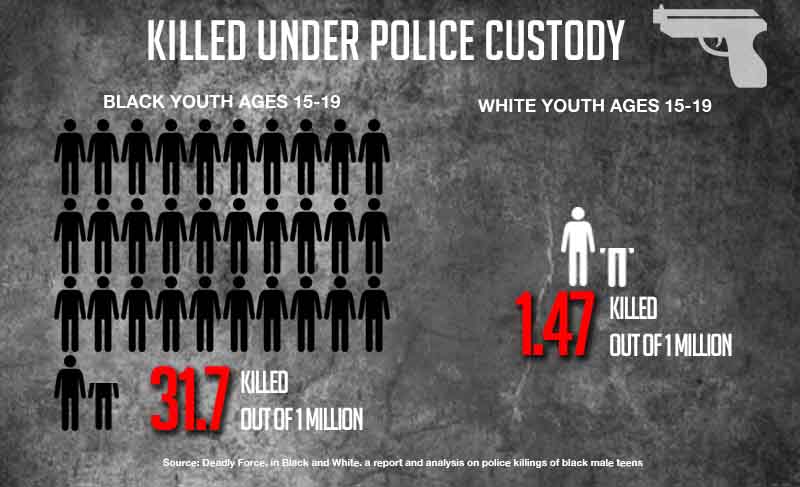
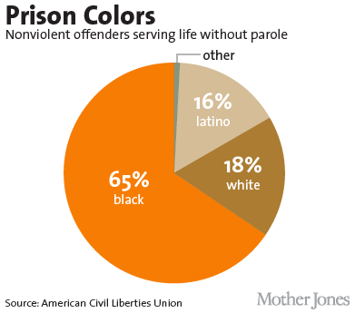
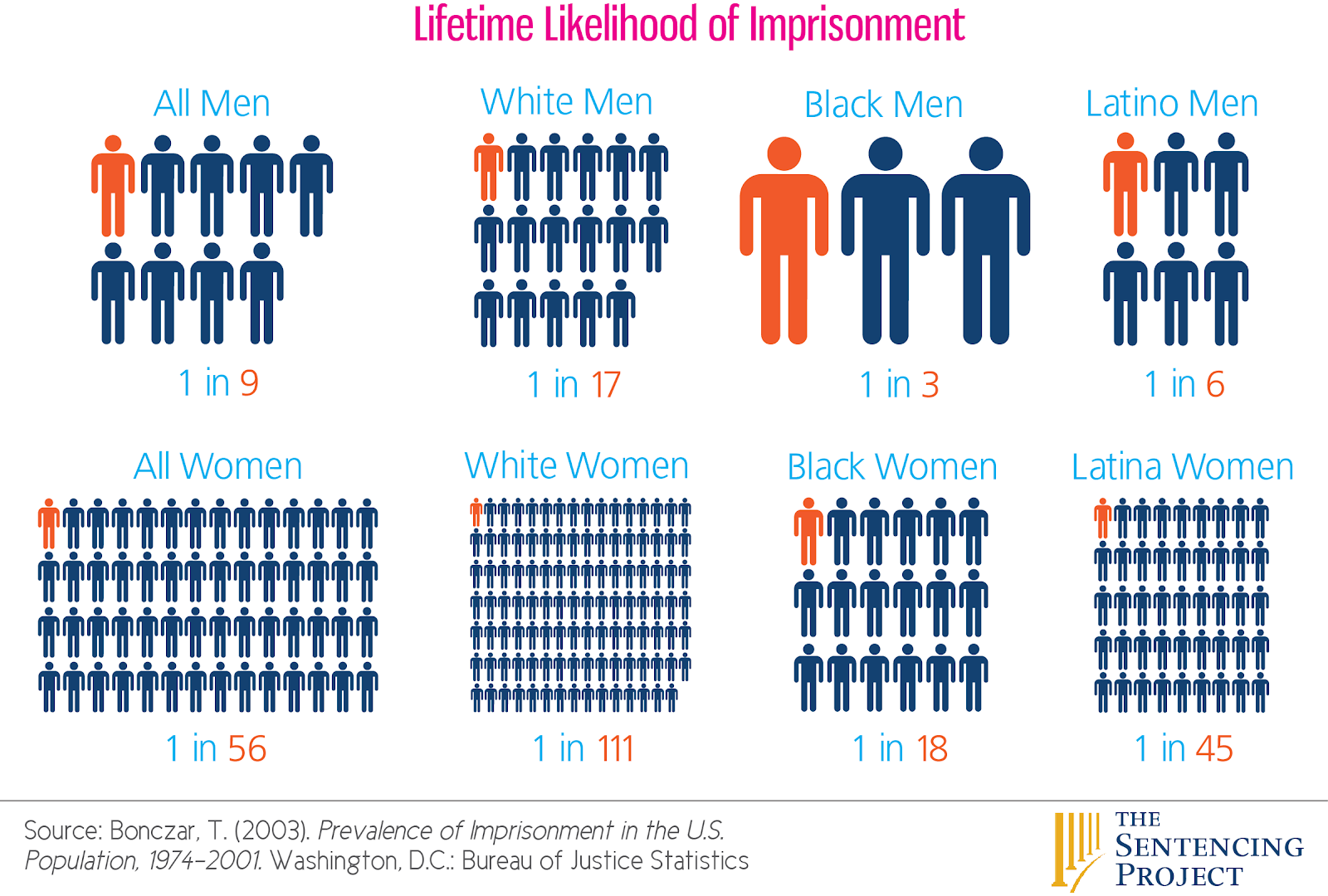


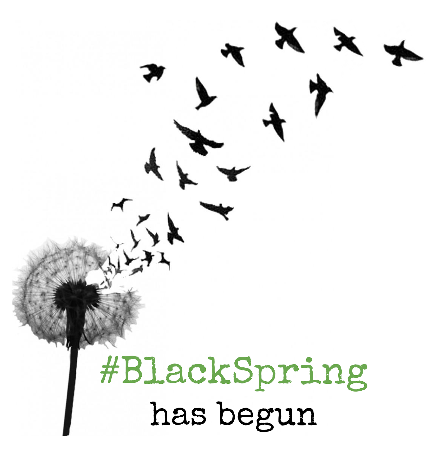
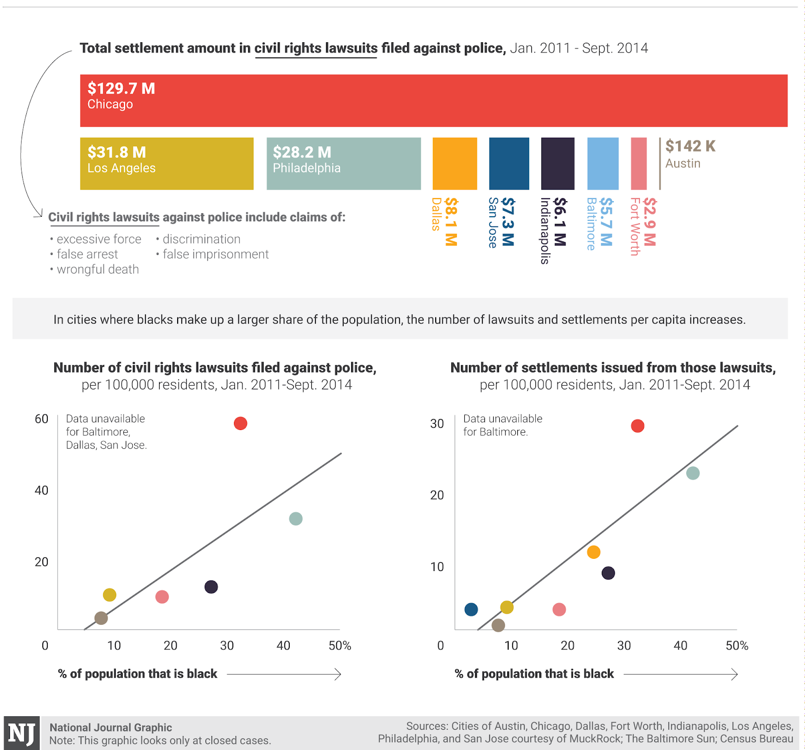
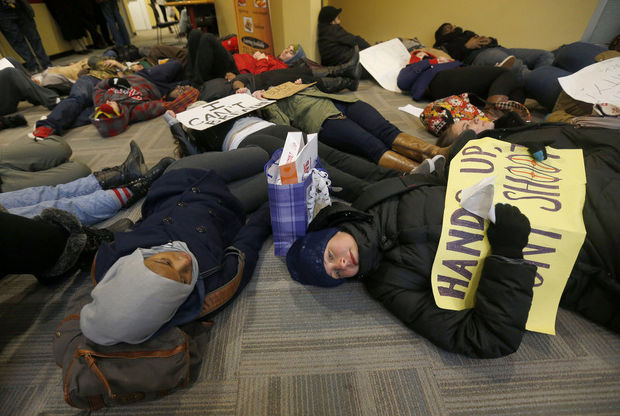
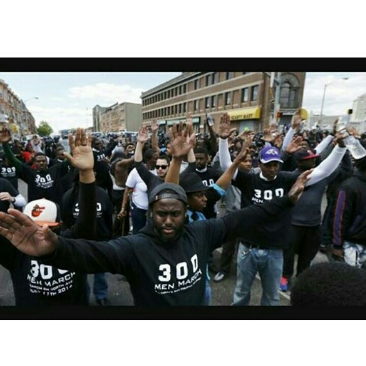

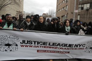
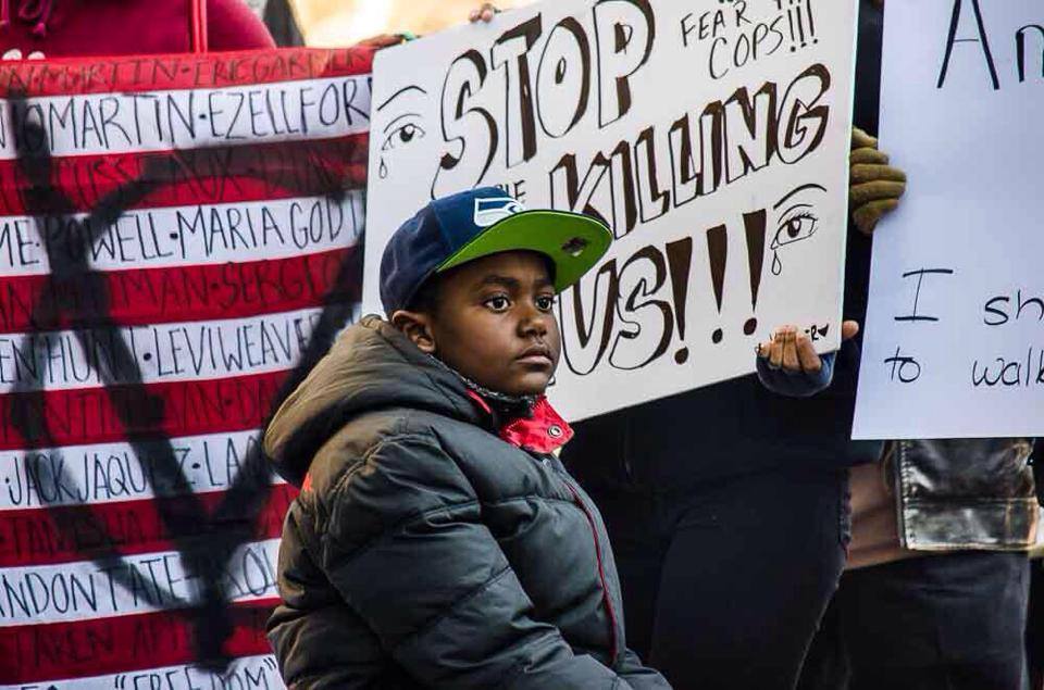
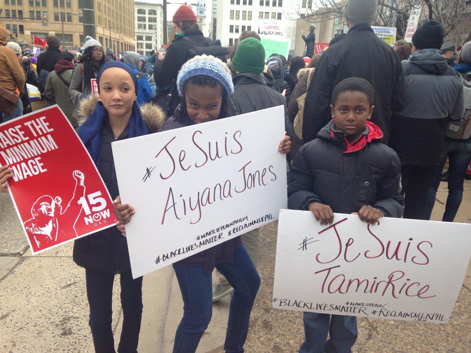
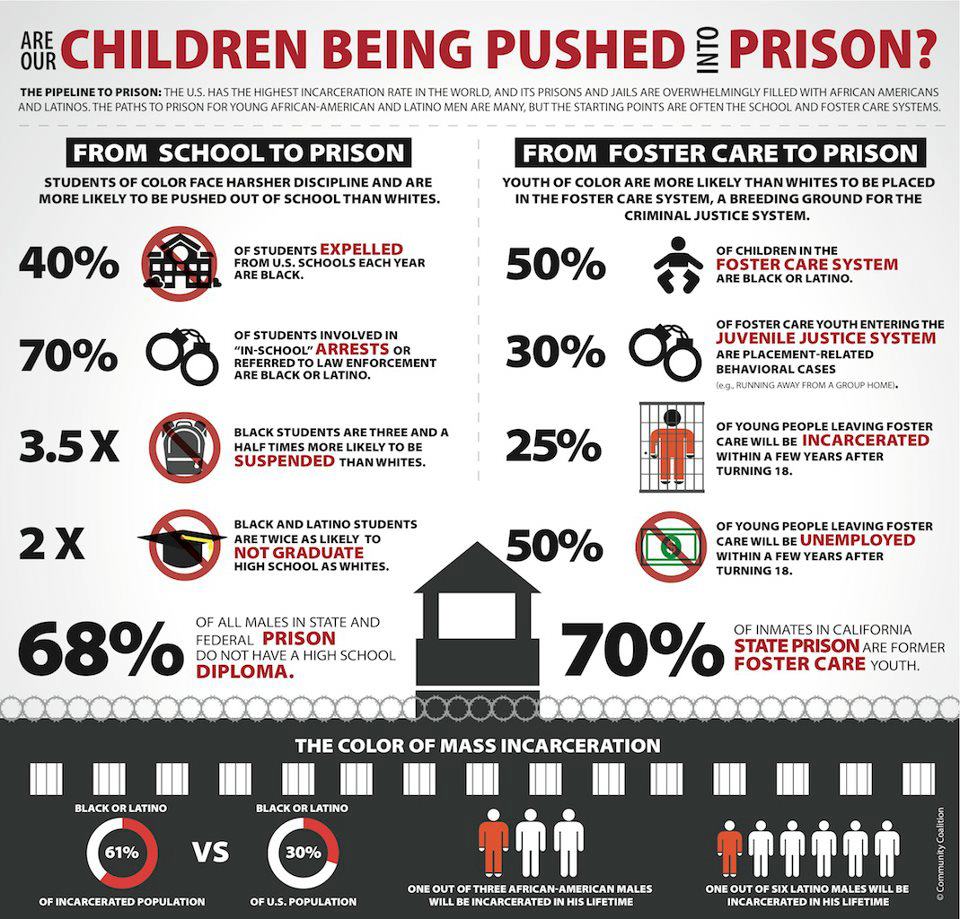

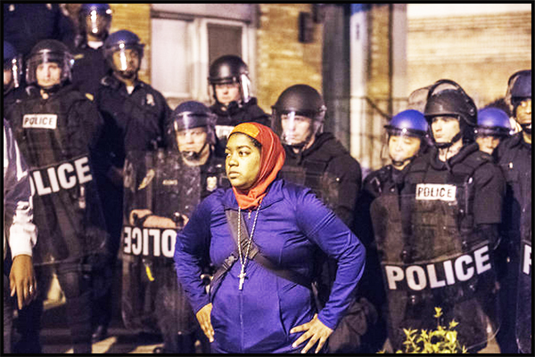


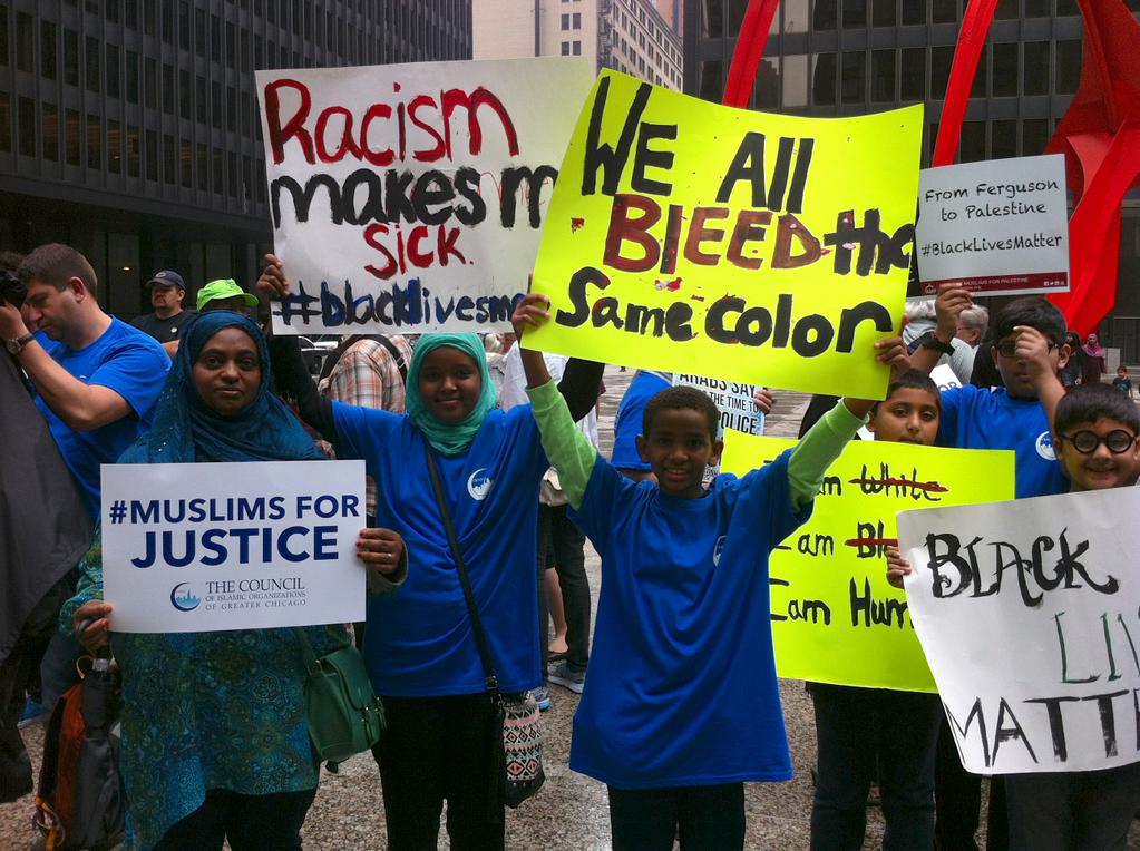