That Iran Propaganda Strategy Thing Began in 2011

Amazing what details can be uncovered and how dates and people all seem to tell a much different story when facts are compiled.

A deeper look is required into Ploughshares and the deep relationship with the White House, as the world has been punked by some well placed organizations and some money…imagine that.

Related: White House Makes the Case for Iran Diplomacy (lots of details here)

Related: Ploughshares at the White House in 2011

Related: Where did Ploughshares get the Money? (Whoa on this one)

Related: Commitments, Verification and Next Steps (Ploughshares going to do the work?)

The Secret History of the Iran-Deal ‘Echo Chamber’

By

Bloomberg: A network of advocates, experts and messaging specialists the White House says helped it sell the Iran nuclear deal in 2015 actually began to campaign for such an accord four years earlier, before the real negotiations started.

Last week I was leaked e-mails and documents from an internal listserv operated by the arms control nonprofit Ploughshares Fund. That foundation has come under scrutiny after the New York Times Magazine quoted top White House foreign policy aide Ben Rhodes boasting how the foundation amplified the White House message in 2015 on the Iran deal. Rhodes told the magazine that supporters of the deal comprised an “echo chamber,” suggesting the independent experts were tools of a White House media campaign.

But the messaging work from Ploughshares on Iran began long before there was any Iran deal and long before Rhodes convened his regular meetings with progressive groups on shaping the Iran narrative.

Beginning in August 2011, Ploughshares and its grantees formed the Iran Strategy Group. Over time this group created a sophisticated campaign to reshape the national narrative on Iran. That campaign sought to portray skeptics of diplomacy as “pro-war,” and to play down the dangers of the Iranian nuclear program before formal negotiations started in 2013 only to emphasize those dangers after there was an agreement in 2015.

The strategy group, which included representatives of the Arms Control Association, the National Security Network, the National Iranian American Council, the Federation of American Scientists, the Atlantic Council and others, sought to “develop process and mechanism to implement Iran campaign strategies, tactics and narrative,” according to an agenda for the first meeting of the group on Aug. 17, 2011.

As a nonprofit, Ploughshares discloses annually the organizations that receive its grants. But until now, the way this network of nonprofits, advocacy organizations and policy experts coordinated its media campaign has been shrouded from the public.

The members of that network had two things in common. They all received substantial grants from Ploughshares and they all sought to prevent a war with Iran. But at the time, the progressives assessed the situation was bleak. An August 2, 2011 memo from Heather Hurlburt, then executive director of the National Security Network, and Peter Ferenbach, a co-founder of ReThink Media, shared with the group an assessment of the “media environment” on Iran and concluded it was “extremely difficult.”

The problem, according to Hurlburt and Ferenbach, was that in 2011 a succession of news stories on Iran, ranging from reports of progress on the country’s nuclear program to the Treasury Department’s designations that accused Iran of colluding with al Qaeda, had put progressives on defense. “We are left in the position of responding to the news headlines and parrying the negative commentary that follows,” they wrote.

Among the authors’ recommendations was that the Iran Strategy Group attack conservatives who advocated military strikes. “On a messaging note, it would be best to describe them as ‘pro-war,’ and leave it to them to back off that characterization of their position,” they wrote.

This approach became a centerpiece of the White House’s own message four years later when Obama was selling his deal to Congress. In a speech at American University that summer he said, “The choice we face is ultimately between diplomacy or some form of war.”

And yet while the Iran Strategy Group’s message about critics of the deal was echoed by the White House, the group’s initial messaging on Iran itself was much different between 2011 and 2013 than what Ploughshares and its grantees ending up saying in 2015. When the White House and its surrogates were campaigning for the deal in 2015, they emphasized how close Iran was to producing the fissile material needed for a nuclear weapon. Joe Cirincione, the president of Ploughshares, made this point in a piece for Slate after the deal was announced when he wrote, “without the deal, Iran could use its centrifuges to purify enough uranium for one or more bombs within weeks.”


This is not an accident. As I reported last year the White House declassified its estimate that Iran was three months away from producing enough fuel for a weapon in April 2015, after a framework for the Iran deal was agreed in Vienna, even though the intelligence community had assessed for more than two years that Iran was three months away from weapons-grade fuel.

Back in 2011, the Iran Strategy Group drafted a set of talking points called “Key Points on Iran and Nuclear Weapons.” Joel Rubin, the director of policy and government affairs for Ploughshares between 2011 and 2014, wrote in an e-mail to the strategy group, “We believe that this paper will help each of you to clearly enunciate, with confidence, a consensus view on how to argue for a sound U.S. policy towards Iran.”

The talking points — drafted by Paul Pillar, the intelligence analyst who was the lead author on the 2002 National Intelligence Estimate shared with Congress before the Iraq war — stressed that diplomacy was the best way to decrease the likelihood Iran went nuclear and that bombing Iran’s facilities would be counterproductive. But the talking points also included “An Iranian nuclear program is not imminent”; “An Iranian nuclear weapon is not inevitable”; and most controversial “If Iran develops a nuclear weapon, the United States and the West could live with it, without important compromise to U.S. interests.” Obama himself has contradicted that last line for years, arguing that he would be prepared to use military force to destroy Iran’s nuclear program if diplomacy did not work.

The Iran Strategy Group sought to play down Iran’s nuclear program as late as 2013. E-mails between strategy group members in August of that year in anticipation of the International Atomic Energy Agency’s report on Iran’s nuclear program that was released at the end of that month show that the network was already in campaign mode.  In an Aug. 20, 2013, e-mail to the Iran Strategy Group, Cirincione encouraged the Ploughshares grantees to “create a social media, web, expert push that carries our main points into the media and policy discussions in the first 12-24 hours.” He recommended that the points the group pushed in the media should include the argument that making enough highly enriched uranium for a single bomb “is just one step in a long weaponization process,” and that while Iran’s decision to start the Arak plutonium reactor was not good, it was “also just one step in a long alternative path to nuclear material for a weapon.”

The timing here is important. In September 2013, Iran and six other great powers including the U.S. announced the beginning of nuclear talks that ultimately produced the agreement in 2015.

Rubin, who is now president of the Washington Strategy Group, told me that the difference in talking points for the Ploughshares network between 2011 and 2013 and then in 2015 reflected the state of diplomacy with Iran and the real concern for progressives that Israel or the U.S. would bomb Iran’s nuclear facilities. “The difference between 2011 and 2015 was that there was a different reality of what was taking place on the ground in terms of the negotiations and the process,” he said. “Ahmadinejad was the president in Iran, there was no negotiation process, and much of the chattering class was talking about when will Israel or the U.S. drop the bomb on Iran in 2011.”

When asked for comment on the story, Ploughshares communications director Jennifer Abrahamson said, “As a nonpartisan public foundation dedicated to reducing nuclear threats, Ploughshares Fund is proud to have supported a network of longstanding experts that helped stop Iran from building a bomb without starting another war in the Middle East.”

That pride is apparent. After a critical story from the AP last week on Ploughshares grants to National Public Radio, Cirincione went on the attack. In a column for Huffington Post suggesting the AP story was part of a campaign from opponents of the Iran deal to discredit him and his organization, he wrote, “Neoconservatives are furious that their efforts to trick the country into another unnecessary war in the Middle East failed.”

Don’t be surprised if you hear Ploughshares grantees repeating that. It sounds like a talking point.

Khamenei: U.S. Cant Touch the Missiles

Khamenei: US ‘can’t do a damn thing’ about our missile programSupreme leader:

West ‘extremely sad’ about failure to curb Iran’s military development; Guards chief: US forced to back down in region

Iranian supreme leader Ali Khamenei on Monday said the United States cannot “do a damn thing” about the Islamic Republic’s ballistic missile program.

“They have engaged in a lot of hue and cry over Iran’s missile capabilities, but they should know that this ballyhoo does not have any influence and they cannot do a damn thing,” Khamenei said, according to the semi-official Fars News Agency.

A missile launched from the Alborz mountains in Iran on March 9, 2016, reportedly inscribed in Hebrew, 'Israel must be wiped out.' (Fars News)

A missile launched from the Alborz mountains in Iran on March 9, 2016, reportedly inscribed in Hebrew, ‘Israel must be wiped out.’ (Fars News)

Iran in March tested ballistic missiles, including two with the words “Israel must be wiped off the earth” emblazoned on them, according to the US and other Western powers. Under a nuclear deal signed last year between world powers and Iran, ballistic missile tests are not forbidden outright but are “not consistent” with a United Nations Security Council resolution from July 2015, US officials say.

According to the UN decision, “Iran is called upon not to undertake any activity related to ballistic missiles designed to be capable of delivering nuclear weapons, including launches using such ballistic missile technology,” until October 2023.

“The US and other powers are extremely sad at this issue and they have no other option; that is why they made huge efforts in order to bring the country’s decision-making and decision-taking centers under their control, but they failed and God willing, they will continue to fail,” Khamanei said on Monday.

The supreme leader, who has final say on state matters, lambasted the “arrogant” Western powers, arguing that efforts to shut down its nuclear program and missile tests were a pretext to meddle in Iran’s affairs.

“The nuclear issue and missiles are excuses and of course excuses are useless and they can do no damn thing,” Khamenei said. “The point is Iran doesn’t follow arrogant powers.”

“In this war, willpowers are fighting. The stronger willpower will win,” Khamenei added.

Also Monday, Iranian Revolutionary Guards general Qassem Soleimani maintained that without the Islamic Republic, the Islamic State would now control all of Syria. The United States has been forced to back down in the region, he said, according to Iranian reports.

Last week, a senior Iranian military commander boasted that the Islamic Republic could “raze the Zionist regime in less than eight minutes.” Ahmad Karimpour, a senior adviser to the Iranian Revolutionary Guards’ elite unit al-Quds Force, said if Khamenei gave the order to destroy Israel, the Iranian military had the capacity to do so quickly.

“If the Supreme Leader’s orders [are] to be executed, with the abilities and the equipment at our disposal, we will raze the Zionist regime in less than eight minutes,” Karimpour said Thursday, according to the semi-official Fars News Agency.
A senior Iranian general on May 9 announced that the country’s armed forces successfully tested a precision-guided, medium-range ballistic missile two weeks earlier that could reach Israel, the state-run Tasnim agency reported.

Iranian Supreme Leader Ali Khamenei meets the Iranian Revolutionary Guards Corps (IRGC) Navy unit that detained US sailors earlier in January, in a photo released by Iran on January 24, 2016.

“We test-fired a missile with a range of 2,000 kilometers and a margin of error of eight meters,” Brigadier General Ali Abdollahi was quoted as saying at a Tehran science conference. The eight-meter margin means the “missile enjoys zero error,” he told conference participants.

****

Iran’s Missile Program/Iran Primer

  • Iran has the largest and most diverse ballistic missile arsenal in the Middle East. (Israel has more capable ballistic missiles, but fewer in number and type.) Most were acquired from foreign sources, notably North Korea. The Islamic Republic is the only country to develop a 2,000-km missile without first having a nuclear weapons capability.
  • Iran is still dependent on foreign suppliers for key ingredients, components and equipment, but it should eventually be able to develop long-range missiles over time, including an Intercontinental Ballistic Missile or ICBM.
  • The military utility of Iran’s current ballistic missiles is limited because of poor accuracy, so missiles are not likely to be decisive if armed with conventional, chemical or biological warheads. But Tehran could use its missiles as a political or psychological weapon to terrorize an adversary’s cities and pressure its government.
  • Iran should not be able to strike Western Europe before 2017 or the United States before 2020—at the earliest.
  • Iran’s space program, which includes the successful launch of a small, crude satellite into low earth orbit using the Safir carrier rocket, proves the country’s growing ambitions and technical prowess.
Overview
Iran’s pursuit of ballistic missiles pre-dates the Islamic revolution. Ironically, the shah teamed with Israel to develop a short-range system after Washington denied his request for Lance missiles. Known as Project Flower, Iran provided the funds and Israel the technology. The monarchy also pursued nuclear technologies, suggesting an interest in a delivery system for nuclear weapons. Both programs collapsed after the revolution.
Under the shah, Iran had the largest air force in the Gulf, including more than 400 combat aircraft. But Iran’s deep-strike capability degraded rapidly after the break in ties with the West limited access to spare parts, maintenance, pilot training and advanced armaments. So Tehran turned to missiles to deal with an immediate war-time need after Iraq’s 1980 invasion. Iran acquired Soviet-made Scud-Bs, first from Libya, then from Syria and North Korea. It used these 300-km missiles against Iraq from 1985 until the war ended in 1988.
Since the war, Tehran has steadily expanded its missile arsenal. It has also invested heavily in its own industries and infrastructure to lessen dependence on unreliable foreign sources. It is now able to produce its own missiles, although some key components still need to be imported. Iran has demonstrated that it can also significantly expand the range of acquired missiles, as it has done with Nodong missiles from North Korea, which it then renamed. Iran’s missiles can already hit any part of the Middle East, including Israel. Over time, Tehran has established the capacity to create missiles to address a full range of strategic objectives.
 
Iran’s expanding arsenal
The Islamic Republic’s arsenal now includes several types of short-range and medium-range missiles. Estimates vary on specifics, and Iran has exaggerated its capabilities in the past. But there is widespread consensus that Tehran has acquired and creatively adapted foreign technology to continuously increase the quality and quantity of its arsenal. It has also launched an ambitious space program that works on some of the same technology. The arsenal includes:
Shahab missiles: Since the late 1980s, Iran has purchased additional short- and medium-range missiles from foreign suppliers and adapted them to its strategic needs. The Shahabs, Persian for “meteors,” were long the core of Iran’s program. They use liquid fuel, which involves a time-consuming launch. They include:
The Shahab-1 is based on the Scud-B. (The Scud series was originally developed by the Soviet Union). It has a range of about 300 kms or 185 miles.
The Shahab-2 is based on the Scud-C. It has a range of about 500 kms, or 310 miles. In mid-2010, Iran is widely estimated to have between 200 and 300 Shahab-1 and Shahab-2 missiles capable of reaching targets in neighboring countries.
The Shahab-3 is based on the Nodong, which is a North Korean missile. It has a range of about 900 km or 560 miles. It has a nominal payload of 1,000 kg. A modified version of the Shahab-3, renamed the Ghadr-1, began flight tests in 2004. It theoretically extends Iran’s reach to about 1,600 km or 1,000 miles, which qualifies as a medium-range missile. But it carries a smaller, 750-kg warhead.
Although the Ghadr-1 was built with key North Korean components, Defense Minister Ali Shamkhani boasted at the time, “Today, by relying on our defense industry capabilities, we have been able to increase our deterrent capacity against the military expansion of our enemies.”
Sajjil missiles: Sajjil means “baked clay” in Persian. These are a class of medium-range missiles that use solid fuel, which offer many strategic advantages. They are less vulnerable to preemption because the launch requires shorter preparation – minutes rather than hours. Iran is the only country to have developed missiles of this range without first having developed nuclear weapons.
This family of missiles centers on the Sajjil-2, a domestically produced surface-to-surface missile. It has a medium-range of about 2,000 km or 1,200 miles when carrying a 750-kg warhead. It was test fired in 2008 under the name, Sajjil. The Sajjil-2, which is probably a slightly modified version, began test flights in 2009. This missile would allow Iran to “target any place that threatens Iran,” according to Brig. Gen. Abdollah Araghi, a Revolutionary Guard commander.
The Sajjil-2, appears to have encountered technical issues and its full development has slowed. No flight tests have been conducted since 2011. If Sajjil-2 flight testing resumes, the missile’s performance and reliability could be proven within a year or two. The missile, which is unlikely to become operational before 2017, is the most likely nuclear delivery vehicle—if Iran decides to develop an atomic bomb. But it would need to build a bomb small enough to fit on the top of this missile, which would be a major challenge.
The Sajjil program’s success indicates that Iran’s long-term missile acquisition plans are likely to focus on solid-fuel systems. They are more compact and easier to deploy on mobile launchers. They require less time to prepare for launch, making them less vulnerable to preemption by aircraft or other missile defense systems.
Iran could attempt to use Sajjil technologies to produce a three-stage missile capable of flying 3,700 km or 2,200 miles. But it is unlikely to be developed and actually fielded before 2017.
Space program: Iran’s ambitious space program provides engineers with critical experience developing powerful booster rockets and other skills that could be used in developing longer-range missiles, including ICBMs.
The Safir, which means “messenger” or “ambassador” in Persian, is the name of the carrier rocket that launched Iran’s first satellite into space in 2009. It demonstrated a new sophistication in multistage separation and propulsion systems.
 
The Simorgh, which is the Persian name of a benevolent, mythical flying creature, is another carrier rocket to launch satellites. A mock-up was unveiled in 2010. It has a cluster of four engines and indicates that Iran’s space program is making progress in its long-term goals.
Development of larger, more powerful launchers could also provide Iran with an ability to place communication and reconnaissance satellites into orbit, independent of foreign powers.
Factoids
  • Iran has invested at least $1 billion in its missile programs since 2000, according to “Iran’s Ballistic Missile Capabilities: A Net Assessment.”
  • Iran’s space program aspires to place an astronaut into earth’s orbit. Development of the Simorgh launcher is a key step towards this objective.
  • Iran’s universities and other technical centers are conducting basic and applied research in support of the missile and space launcher development programs.
Limitations
Iran’s ballistic missiles have poor accuracy. The successful destruction of a single fixed military target, for example, would probably require Iran to use a significant percentage of its missile inventory. Against large military targets, such as an airfield or seaport, Iran could conduct harassment attacks aimed at disrupting operations or damaging fuel-storage depots. But the missiles would probably be unable to shut down critical military activities. The number of transporter-erector-launchers (TELs) available and the delays to reload them would also limit the impact of even a massive attack.
Without a nuclear warhead, Iran’s ballistic missiles are likely to be more effective as a political tool to intimidate or terrorize an adversary’s urban areas, increasing pressure for resolution or concessions. Such attacks might trigger fear, but the casualties would probably be low – probably less than a few hundred, even if Iran unleashed its entire ballistic missile arsenal and a majority succeeded in penetrating missile defenses.
Iran is also likely to face difficulties if it decides to develop a “second-generation” intermediate-range missile of 4,000 km to 5,000 km, or 2,500 miles to 3,100 miles, using solid-fuel technology. Its engineers would have to design, develop and test a much larger rocket motor. There is little reason to believe that the Islamic Republic could field such a missile before 2018. Moreover, Iran would still have to rely on imported technologies, components and technical assistance, and carry out a lengthy flight-test program.
Finally, Iran’s past missile and space-launcher efforts suggest that Tehran would probably develop and field an intermediate-range missile before trying to develop an intercontinental ballistic missile capable of reaching the United States more than 9,000 km or 5,600 miles away. So an Iranian ICBM seems unlikely before 2020.
Trendlines
  • Although Iran’s ballistic missiles are too inaccurate to be militarily effective when armed with conventional warheads, the regime likely believes that the missiles can deter and possibly intimidate its regional adversaries, regardless of warhead type.
  • Iran’s advanced engineering capabilities and commitment to missile and space launcher programs are likely, over time, to lead to development of additional missile systems. Export controls will slow, but not stop progress.
  • There is no strong evidence that Iran is actively developing an intermediate-range or intercontinental ballistic missile. And a new system can’t be deployed out of the blue. If Iran decides to pursue an intermediate-range capability, the necessary flight testing will provide a three-to-five year window for developing countermeasures.


Psst, Another Scandal, Thomas Pickering/Panama Papers

Who is Tom Pickering? He is the fella that Hillary tapped to do the Accountability Review Board Report on Benghazi. And, thanks to my buddy Clare Lopez, former CIA, she authored a white paper on ol’ Thomas and his pro-Iran lobby.

Pickering was also part of a secret group to lobby the lifting of sanctions on Iran. The White House lobby operation for Iran was huge, well funded and full of collusion.

Well, there is more to Mr. Pickering.

Panama Papers detail how ex-ambassador helped Russian company

McClatchy:  WASHINGTON ~ MarisaTaylor: As Russian software company Luxoft prepared to offer shares on the U.S. stock market, its executives turned to a well-known U.S. diplomat.

Thomas Pickering, a former U.S. ambassador to Russia who also served as undersecretary of state for political affairs under President Bill Clinton, agreed in May 2013 to be a director of Luxoft Holding Inc. a month before the company’s debut on the New York Stock Exchange.


The relationship between Luxoft and Pickering, whose diplomatic career spans six presidents and four decades, is detailed in the massive Panama Papers leak and comes amid a global debate over the role of offshore companies. Luxoft is incorporated in the British Virgin Islands.

Pickering is the highest-level former U.S. official to be identified as involved in a Panama Papers offshore company so far. The papers, which were leaked from the Panama law firm Mossack Fonseca to an international group of reporters, including the International Consortium of Investigative Journalists and McClatchy, have already revealed that former and current world leaders had offshore companies and have led to criminal inquiries around the globe, including in the United States.

However, nothing appears illegal or unethical about Pickering’s role, experts said. Pickering said in an interview that he had disclosed his role on Luxoft’s board to the State Department as required under government ethics rules.

“I disclosed about 150 interests, including that I was on this board,” he said. “It is a Russian company and – obviously for tax reasons or otherwise – incorporated itself in Tortola, the British Virgin Islands. That I knew. And I didn’t see any problem with that.”

He also said he’d donated his compensation from the company to charity.

Luxoft declined to comment. “As a public company we do not respond to unsolicited enquiries of this nature,” Natasha Ziabkina, general counsel of Luxoft Group, wrote in an email to McClatchy. “Any material information about our company is disclosed through our publicly available securities filings.”

Pickering said he’d also disclosed his role and had donated compensation when he served until about four years ago on the board of TMK, a Russian manufacturer and exporter of steel pipes for the oil and gas industry.


“I’ve been very careful in my dealings with the boards,” Pickering said.

Pickering said he had been approached to be on Luxoft’s board years before the company went public on the British and American stock exchanges, by a Luxoft executive he’d known while he was senior vice president of international relations for Boeing Co. from 2000 to 2006. Boeing was a client of Luxoft.

“I got to know them and I got to know the man who ran Luxoft,” Pickering said. “Years ago, he said if we go on the London market or on the U.S. would I join their board. I said in principle I would.”


After the company went public in London, Pickering said, he looked into the company and decided to join the board. He also serves on Luxoft’s audit committee.

Pickering was appointed director of Luxoft Holding at a time when the company still had ties to one of Russia’s biggest banks, VTB Bank. Rus Lux Limited, the VTB-linked company, had a 10.2 percent stake in Luxoft.

Luxoft has generally performed well since its formation. It was among the best-performing major Russian companies on the New York Stock Exchange in 2014. And earlier this month it reported that its fourth-quarter revenue had increased 23.2 percent over the previous year.

In the Mossack Fonseca documents, Luxoft reassures the law firm in December 2015 that Rus Lux had sold its shares before the U.S government sanctioned VTB in July 2014. The U.S. Treasury Department issued the sanctions against VTB and other Russian banks in response to Russia’s role in the Ukrainian conflict.

“Rus Lux Limited was a minority shareholder a long time ago,” wrote Ziabkina, general counsel of Luxoft Group. “They fully divested and sold their shares in Luxoft Holding in November 2013 before the sanctions took effect.”

New York University law professor Stephen Gillers said he didn’t see any ethical problem with Pickering’s relationship with Luxoft.

“What else is new?” asked Gillers. “Yes, people sometimes use their former government experience to do exactly this.”

Jay Ritter, a University of Florida business professor, said Luxoft’s inclusion of Pickering on its board was not unusual for foreign companies gearing up for an initial public stock offering in the U.S.

“When you’re dealing with a company in Russia – whether they’ve got to set it up in the British Virgin Islands or not, there’s a required leap of faith for investors,” said Ritter, an expert on IPOs. “Appointing someone like Pickering to the board gives a certain amount of credibility because he’s got his personal reputation at stake. Presumably, he doesn’t want to get involved with something that’s obviously sleazy.”

Pickering has served as the U.S. ambassador to the Russian Federation, India, Israel, El Salvador, Nigeria and Jordan, and to the United Nations.

Luxoft also disclosed his role in its public filings with the U.S. Securities and Exchange Commission. The company has its operating headquarters in Switzerland.

State Department spokesman John Kirby declined to comment on the Panama Papers.

Kirby said Pickering was required to file financial disclosure forms with the State Department because he served as one of 25 members of the first Foreign Affairs Policy Board.

The board was launched in December 2011 to provide the secretary of state and senior department officials with independent advice on U.S. foreign policy.

Pickering served a two-year term on the board from December 2011 to December 2013. He returned to the board in 2014 and remains a member. Members of the Foreign Affairs Policy Board do not work full time as members of the board, but in an advisory capacity.

The former ambassador also chaired the Accountability Review Board, which investigated the 2012 fatal attacks in Benghazi, Libya, that killed four Americans, including an ambassador. The panel concluded in its December 2012 report that security at the facility in Benghazi was “grossly inadequate,” leading to the suspension of four State Department officials. They were reinstated by Secretary of State John Kerry in August 2013.

Pickering continued to offer advice to the Obama administration, according to emails that the State Department released during a controversy over Democratic presidential candidate Hillary Clinton’s emails.

Pickering wasn’t compensated for any position, Kirby said.


Confused About the Middle East That Costs Us Billions?

You are not alone if foreign policy is either boring, confusing or just over there. Foreign policy is domestic policy given what we are forced to spend in money and human treasure to maintain some kind of equilibrium in the region. Under the Obama regime, the United States has backed off substantially and the reasons were explained in the Jeffrey Goldberg Atlantic article which was a VERY long read. However, it is important because war and political conflict began in the 70’s for the United States and has no end in sight as told by the intelligence experts due to militant Islam.

Fighting against Islam has been a centuries old condition and there is no forecast for any sort of resolution while treaties, accords and agreements have populated presidential administrations for decades.

We, in the West just cannot bail out and leave it to those ‘over there’ to deal with it all, as there are countless ramifications to that notion, and we are war weary. We are out of money and out of solutions. Do we stay the course in some form?

Below are some maps to help you understand better the entire region, the history and the dynamic of where the world is today. Maps are of great help and this should be a useful tool.

40 maps that explain the Middle East

by Max Fisher on March 26, 2015

Vox: Maps can be a powerful tool for understanding the world, particularly the Middle East, a place in many ways shaped by changing political borders and demographics. Here are 40 maps crucial for understanding the Middle East — its history, its present, and some of the most important stories in the region today.

Middle East History

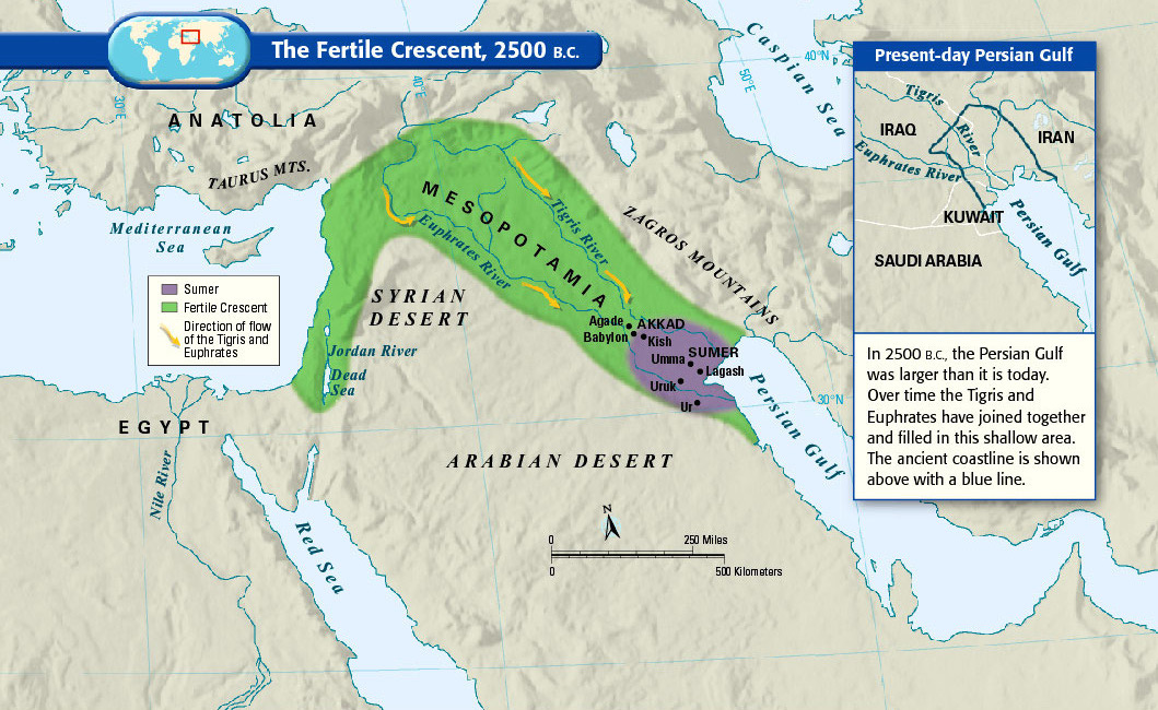
  1. The fertile crescent, the cradle of civilization

    The fertile crescent, the cradle of civilization

    If this area wasn’t the birthplace of human civilization, it was at least a birthplace of human civilization. Called “the fertile crescent” because of its lush soil, the “crescent” of land mostly includes modern-day Iraq, Syria, Jordan, and Israel-Palestine. (Some definitions also include the Nile River valley in Egypt.) People started farming here in 9000 BC, and by around 2500 BC the Sumerians formed the first complex society that resembles what we’d now call a “country,” complete with written laws and a political system. Put differently, there are more years between Sumerians and ancient Romans than there are between ancient Romans and us.

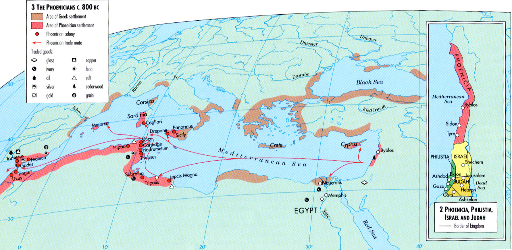
  2. How ancient Phoenicians spread from Lebanon across the Mediterranean

    How ancient Phoenicians spread from Lebanon across the Mediterranean

    The Phoenicians, who lived in present-day Lebanon and coastal Syria, were pretty awesome. From about 1500 to 300 BC, they ran some of the Mediterranean’s first big trading networks, shown in red, and dominated the sea along with the Greeks, who are shown in brown. Some sailed as far as the British Isles, and many of them set up colonies in North Africa, Spain, Sicily, and Sardinia. This was one of the first of many close cultural links between the Middle East and North Africa – and why Libya’s capital, Tripoli, still bears the name of the ancient Phoenician colony that established it.

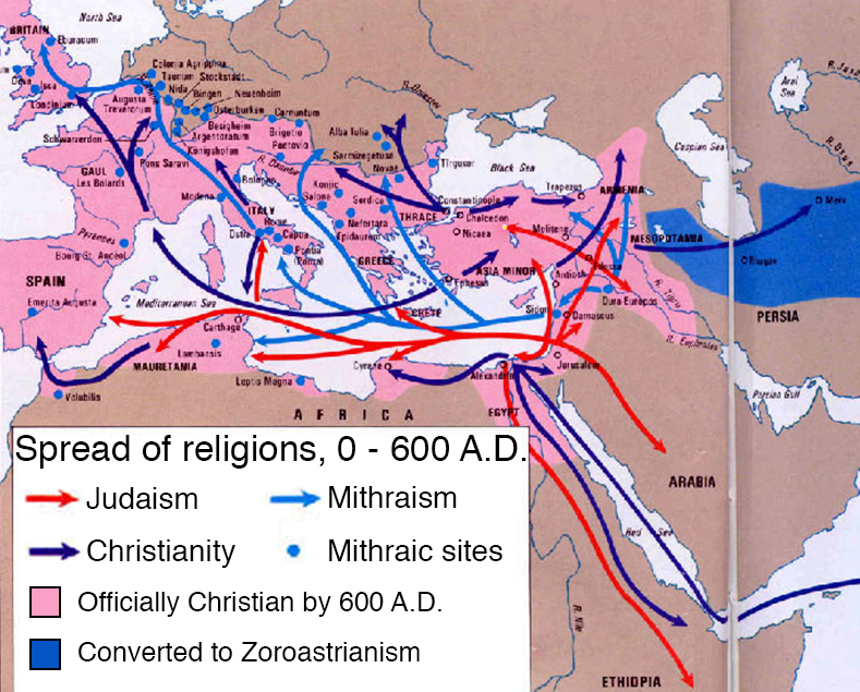
  3. How the Middle East gave Europe religion, three times

    How the Middle East gave Europe religion, three times

    The Middle East actually gave Europe religion four times, including Islam, but this map shows the first three. First was Judaism, which spread through natural immigration and when Romans forcibly dispersed the rebelling Israelites in the first and second century AD. In the first through third centuries A.D., a religion called Mithraism — sometimes called a “mystery religion” for its emphasis on secret rites and clandestine worship — spread from present-day Turkey or Armenia throughout the Roman Empire (at the time, most adherents believed it was from Persians in modern-day Iran, but this is probably wrong). Mithraism was completely replaced with Christianity, which became the Roman Empire’s official religion, after a few centuries. It’s easy to forget that, for centuries, Christianity was predominantly a religion of Middle Easterners, who in turn converted Europeans.

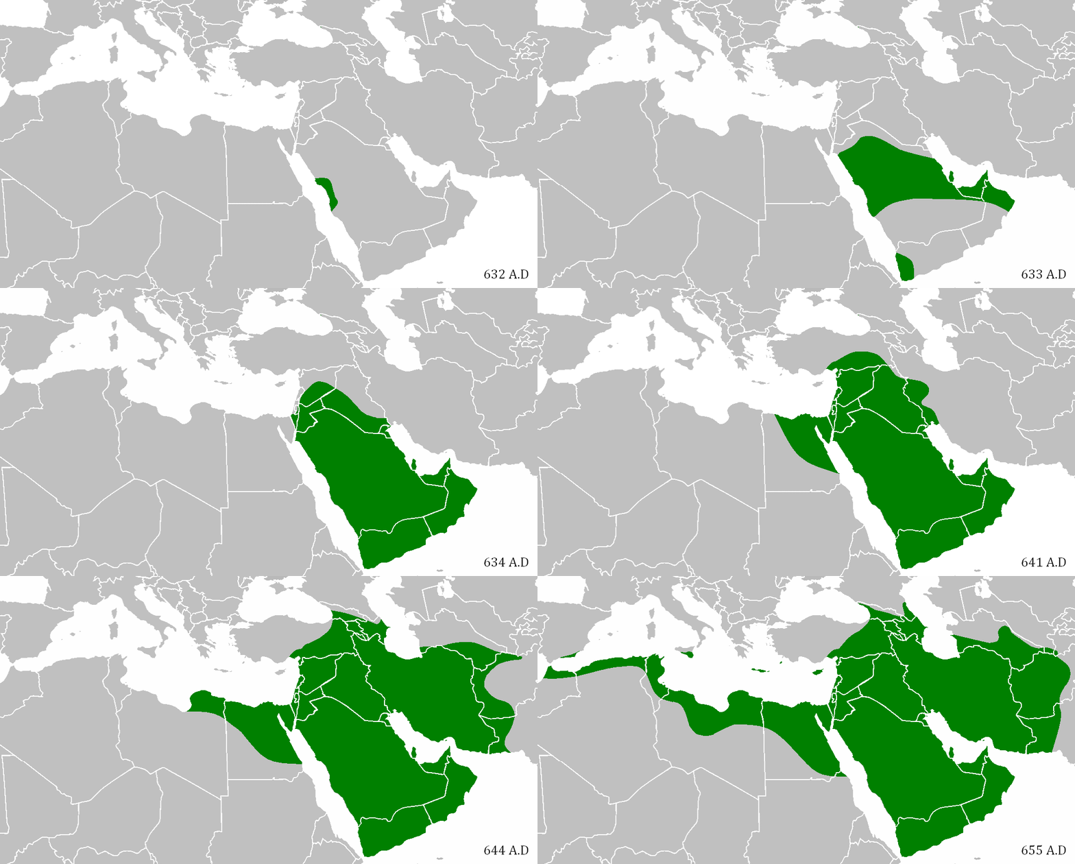
  4. When Mohammed’s Caliphate conquered the Middle East

    When Mohammed’s Caliphate conquered the Middle East

    In the early 7th century AD in present-day Saudi Arabia, the Prophet Mohammed founded Islam, which his followers considered a community as well as a religion. As they spread across the Arabian peninsula, they became an empire, which expanded just as the neighboring Persian and Byzantine Empires were ready to collapse. In an astonishingly short time — from Mohammed’s death in 632 to 652 AD — they managed to conquer the entire Middle East, North Africa, Persia, and parts of southern Europe. They spread Islam, the Arabic language, and the idea of a shared Middle Eastern identity — all of which still define the region today. It would be as if everyone in Europe still spoke Roman Latin and considered themselves ethnically Roman.

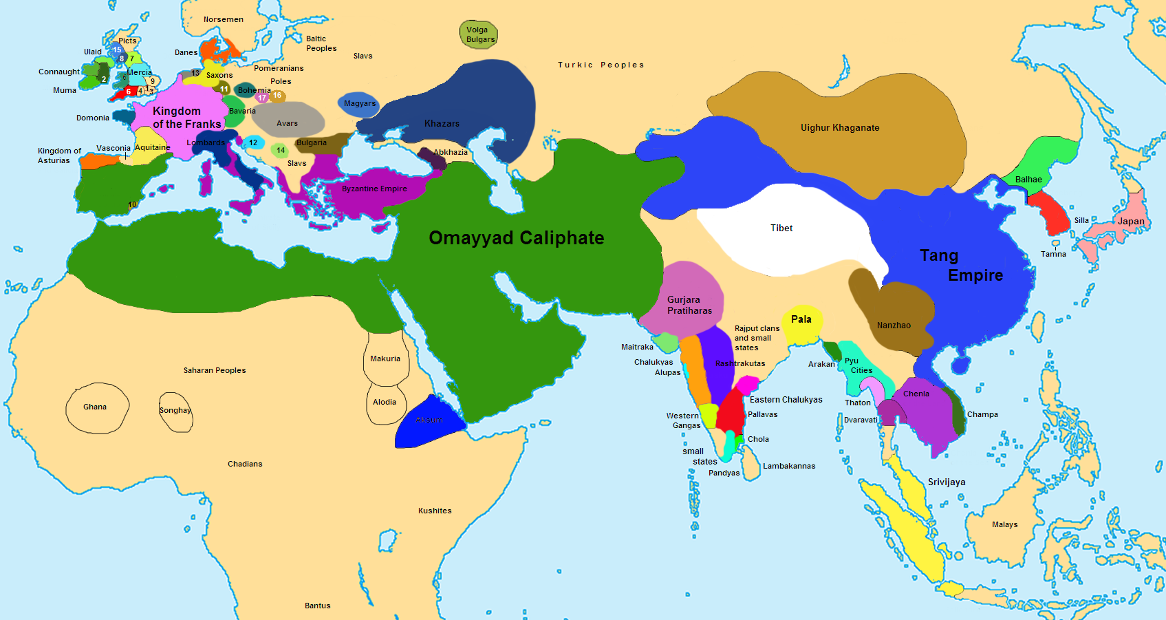
  5. A map of the world at the Caliphate’s height

    A map of the world at the Caliphate’s height

    This is a rough political map of the world in 750 AD, at the height of the Omayyad Caliphate (“caliph” means the ruler of the global Islamic community). This is to give you a sense of how vast and powerful the Muslim empire had become, barely one century after the founding of the religion that propelled its expansion. It was a center of wealth, arts, and learning at a time when only China was so rich and powerful. This was the height of Arab power.

  6. The six-century rise and fall of the Ottoman Empire

    The six-century rise and fall of the Ottoman Empire

    The Ottoman Empire is named for Osman, its first ruler, who in the early 1300s expanded it from a tiny part of northwest Turkey to a slightly less tiny part. It continued expanding for about 500 years — longer than the entire history of the Roman Empire — ruling over most of the Middle East, North Africa, and southeastern Europe for centuries. The empire, officially an Islamic state, spread the religion in southeast Europe but was generally tolerant of other religious groups. It was probably the last great non-European empire until it began declining in the mid-1800s, collapsed after World War I, and had its former territory in the Middle East divided up by Western Europe.

  7. What the Middle East looked like in 1914

    What the Middle East looked like in 1914

    This is a pivotal year, during the Middle East’s gradual transfer from 500 years of Ottoman rule to 50 to 100 years of European rule. Western Europe was getting richer and more powerful as it carved up Africa, including the Arab states of North Africa, into colonial possessions. Virtually the entire region was ruled outright by Europeans or Ottomans, save some parts of Iran and the Arabian peninsula divided into European “zones of influence.” When World War I ended a few years later, the rest of the defeated Ottoman Empire would be carved up among the Europeans. The lines between French, Italian, Spanish, and British rule are crucial for understanding the region today – not just because they ruled differently and imposed different policies, but because the boundaries between European empires later became the official borders of independence, whether they made sense or not.

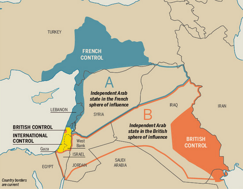
  8. The Sykes-Picot treaty that carved up the Middle East

    The Sykes-Picot treaty that carved up the Middle East

    You hear a lot today about this treaty, in which the UK and French (and Russian) Empires secretly agreed to divide up the Ottoman Empire’s last MidEastern regions among themselves. Crucially, the borders between the French and British “zones” later became the borders between Iraq, Syria, and Jordan. Because those later-independent states had largely arbitrary borders that forced disparate ethnic and religious groups together, and because those groups are still in terrible conflict with one another, Sykes-Picot is often cited as a cause of warfare and violence and extremism in the Middle East. But scholars are still debating this theory, which may be too simple to be true.

  9. An animated history of great empires in the Middle East

    An animated history of great empires in the Middle East

    You may have noticed a theme of the last eight maps: empires, mostly from outside the Middle East but sometimes of it, conquering the region in ways that dramatically changed it. This animation shows you every major empire in the Middle East over the last 5,000 years. To be clear, it is not exhaustive, and in case it wasn’t obvious, the expanding-circle animations do not actually reflect the speed or progression of imperial expansions. But it’s a nice primer.

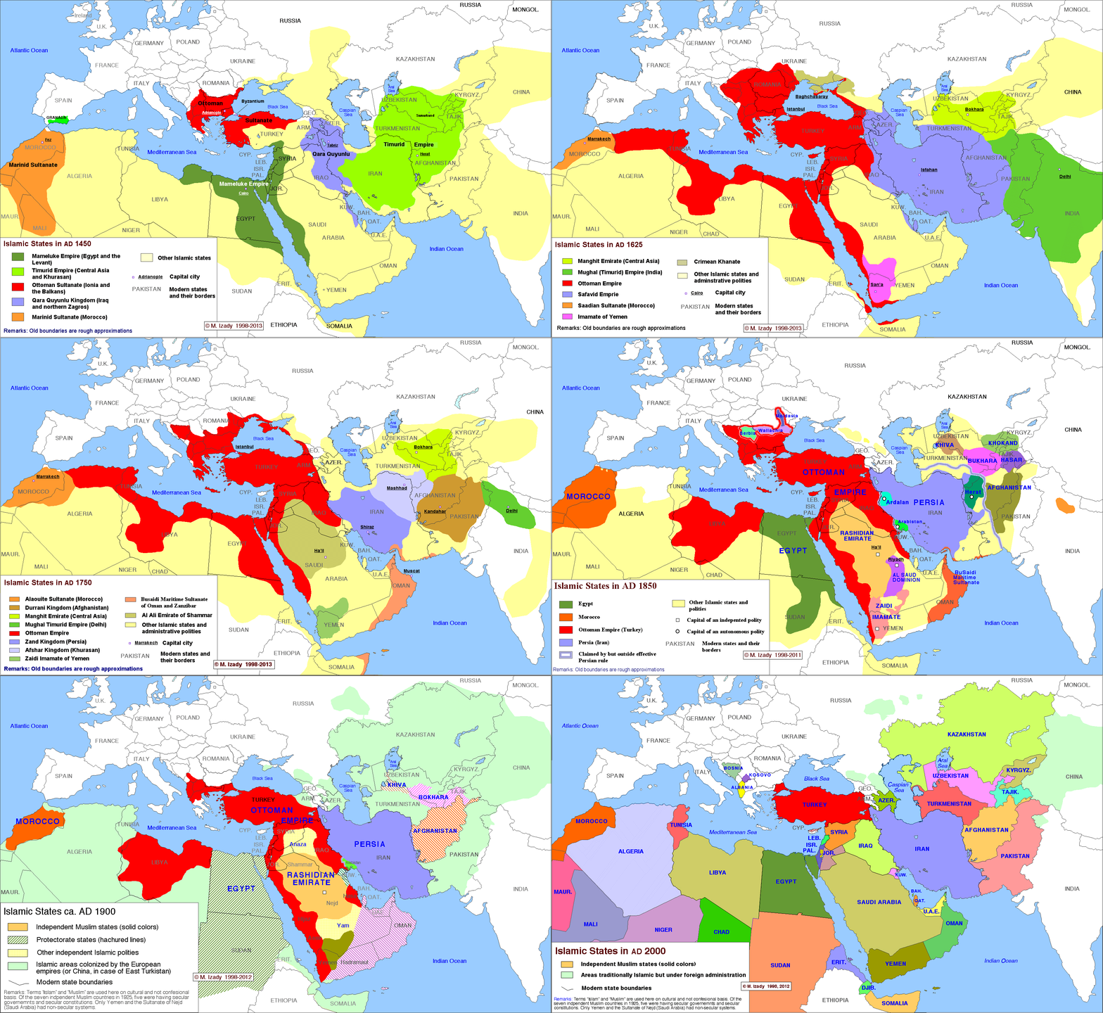
  10. The complete history of Islamic states

    The complete history of Islamic states

    This time-lapse map by Michael Izady — a wonderful historian and cartographer at Columbia University, whose full collection can be found here — shows the political boundaries of the greater Middle East from 1450 through today. You’ll notice that, for much of the last 500 years, most or all of the region has been under some combination of Turkish, Persian, and European control. For so much of the Arab Middle East to be under self-rule is relatively new. Two big exceptions that you can see on this map are Morocco and Egypt, which have spent more of the last 500 years as self-ruling empires than other Arab states. That’s part of why these two countries have sometimes seen themselves as a degree apart from the rest of the Arab world.

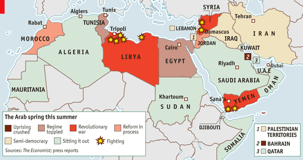
  11. The 2011 Arab Spring

    The 2011 Arab Spring

    It is still amazing, looking back at early and mid-2011, how dramatically and quickly the Arab Spring uprisings challenged and in many cases toppled the brittle old dictatorships of the Middle East. What’s depressing is how little the movements have advanced beyond those first months. Syria’s civil war is still going. Egypt’s fling with democracy appeared to end with a military coup in mid-2013. Yemen is still mired in slow-boil violence and political instability. The war in Libya toppled Moammar Qaddafi, with US and European support, but left the country without basic security or a functioning government. Only Tunisia seems to have come out even tenuously in the direction of democracy.


The Middle East today

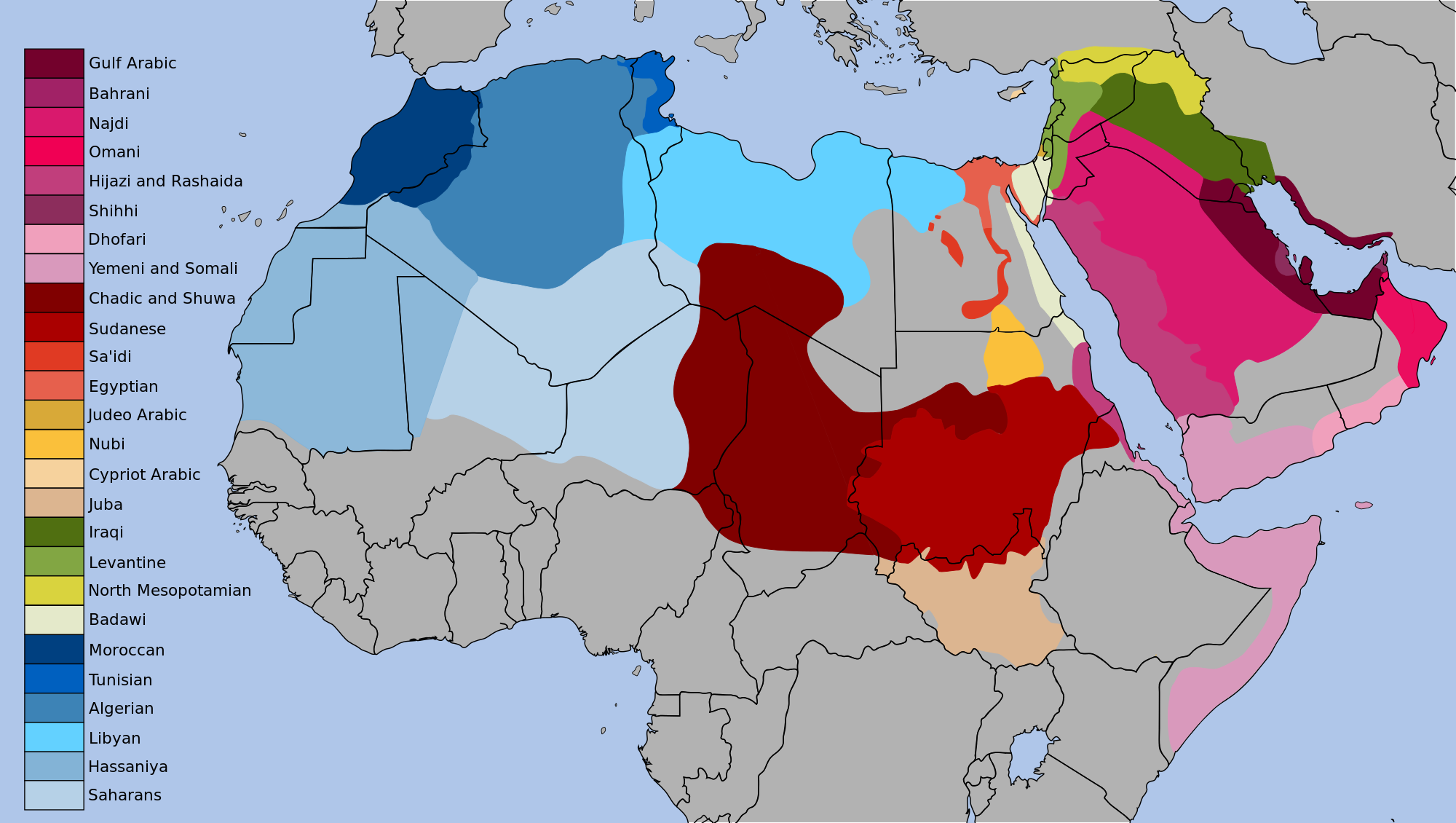
  1. The dialects of Arabic today

    The dialects of Arabic today

    This map shows the vast extent of the Arabic-speaking world and the linguistic diversity within it. Both go back to the Caliphates of the sixth and seventh century, which spread Arabic from its birthplace on the Arabian Peninsula across Africa and the Middle East. Over the last 1,300 years the language’s many speakers have diverged into distinct, sometimes very different, dialects. Something to look at here: where the dialects do and do not line up with present-day political borders. In places where they don’t line up, you’re seeing national borders that are less likely to line up with actual communities, and in some cases more likely to create problems.

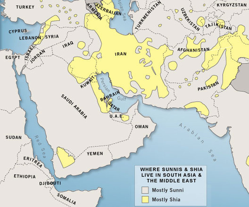
  2. The Sunni-Shia divide

    The Sunni-Shia divide

    The story of Islam’s division between Sunni and Shia started with the Prophet Mohammed’s death in 632. There was a power struggle over who would succeed him in ruling the Islamic Caliphate, with most Muslims wanting to elect the next leader but some arguing that power should go by divine birthright to Mohammed’s son-in-law, Ali. That pro-Ali faction was known as the “Partisans of Ali,” or “Shi’atu Ali” in Arabic, hence “Shia.” Ali’s eventual ascension to the throne sparked a civil war, which he and his partisans lost. The Shia held on to the idea that Ali was the rightful successor, and grew into an entirely separate branch of Islam. Today about 10 to 15 percent of Muslims worldwide are Shia — they are the majority group in Iran and Iraq only — while most Muslims are Sunni. “Sunni” roughly means “tradition.” Today, that religious division is again a political one as well: it’s a struggle for regional influence between Shia political powers, led by Iran, versus Sunni political powers, led by Saudi Arabia. This struggle looks an awful lot like a regional cold war, with proxy battles in Syria and elsewhere.

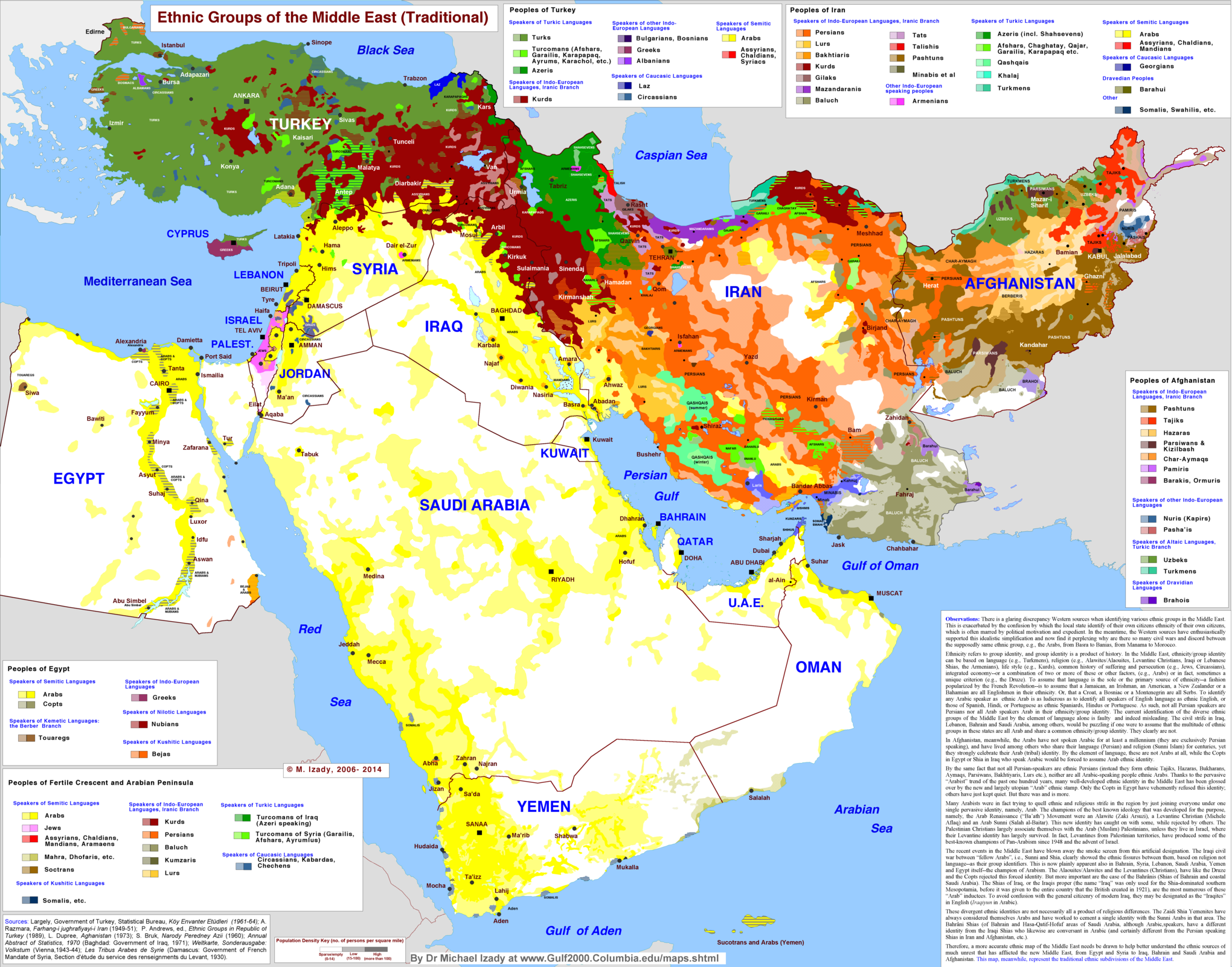
  3. The ethnic groups of the Middle East

    The ethnic groups of the Middle East

    The most important color on this map of Middle Eastern ethnic groups is yellow: Arabs, who are the majority group in almost every MidEast country, including the North African countries not shown here. The exceptions are mostly-Jewish Israel in pink, mostly-Turkish Turkey in green, mostly-Persian Iran in orange, and heavily diverse Afghanistan. (More on the rich diversity of Iran and Afghanistan below.) That splash of red in the middle is really important: ethnic Kurds, who have no country of their own but big communities in Iran, Iraq, Syria, and Turkey. But the big lesson of this map is that there is a belt of remarkable ethnic diversity from Turkey to Afghanistan, but that much of the rest of the region is dominated by ethnic Arabs.

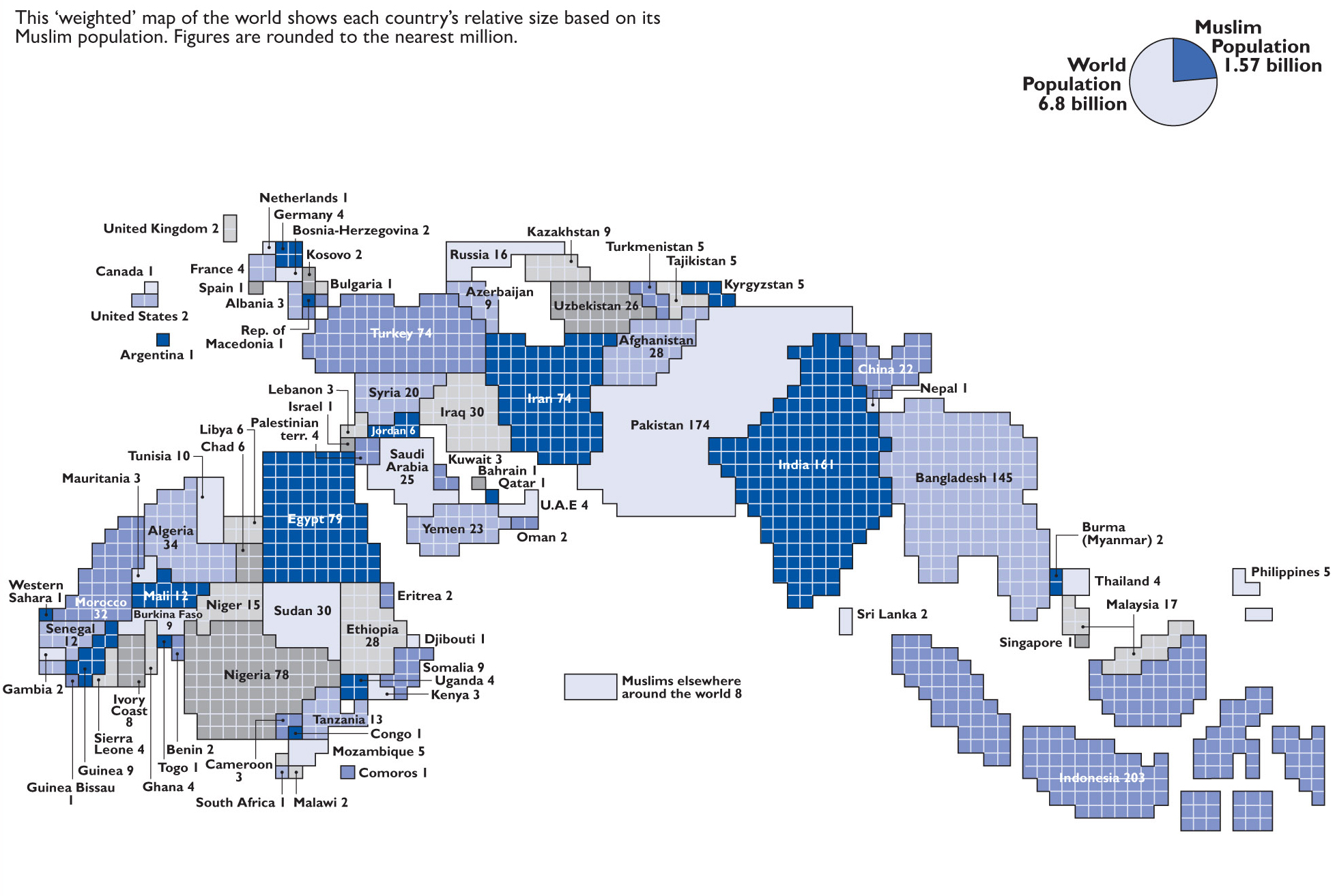
  4. Weighted Muslim populations around the world

    Weighted Muslim populations around the world

    This map makes a point about what the Middle East is not: it is not synonymous with the Islamic world. This weighted population map shows every country in the world by the size of its Muslim population. Countries with more Muslim citizens are larger; countries with fewer Muslim citizens are smaller. You’ll notice right away that the Middle East makes up just a fraction of the world’s total Muslim population. There are far more Muslims, in fact, in the South Asian countries of India, Pakistan, and Bangladesh. The biggest Muslim population by far is Indonesia’s, in southeast Asia. And there are millions in sub-Saharan Africa as well. The Islamic world may have begun in the Middle East, but it’s now much, much larger than that.


Israel-Palestine

  1. Israel’s 1947 founding and the 1948 Israeli-Arab War

    Israel's 1947 founding and the 1948 Israeli-Arab War

    Left map: Passia; center and right maps: Philippe Rekacewicz / Le Monde Diplomatique

    Israel’s 1947 founding and the 1948 Israeli-Arab War

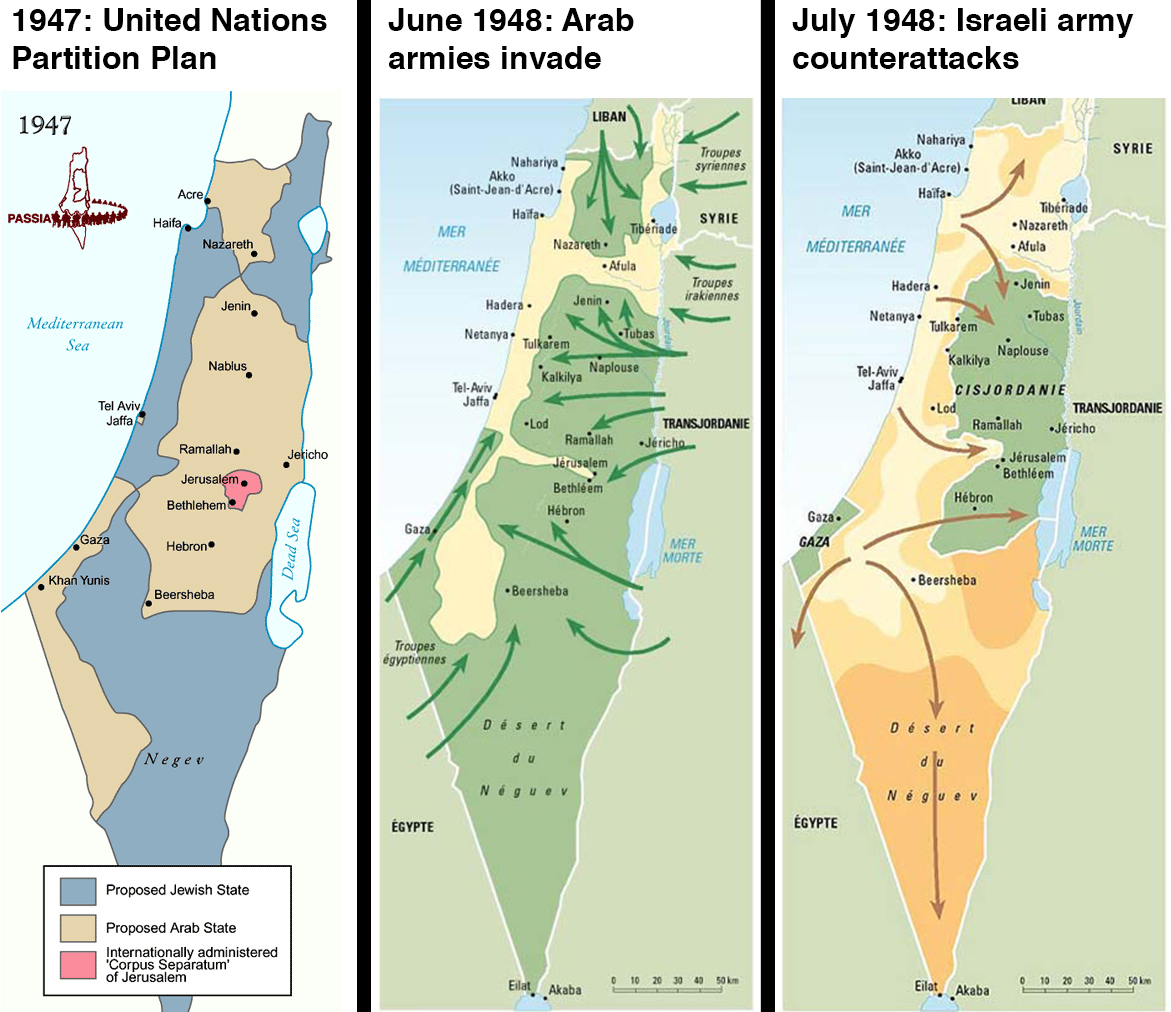
    These three maps show how Israel went from not existing to, in 1947 and 1948, establishing its national borders. It’s hard to identify a single clearest start point to the Israel-Palestine conflict, but the map on the left might be it: these are the borders that the United Nations demarcated in 1947 for a Jewish state and an Arab state, in what had been British-controlled territory. The Palestinians fought the deal, and in 1948 the Arab states of Egypt, Jordan, Iraq, and Syria invaded. The middle map shows, in green, how far they pushed back the Jewish armies. The right-hand map shows how the war ended: with an Israeli counterattack that pushed into the orange territory, and with Israel claiming that as its new national borders. The green is what was left for Palestinians.

  2. The 1967 Israeli-Arab War that set today’s borders

    The 1967 Israeli-Arab War that set today's borders

    BBC

    The 1967 Israeli-Arab War that set today’s borders

    These three maps (click the expand icon to see the third) show how those 1948 borders became what they are today. The map on left shows the Palestinian territories of Gaza, which was under Egyptian control, and the West Bank, under Jordanian control. In 1967, Israel fought a war with Egypt, Jordan, and Syria. The war ended with Israel occupying both of the Palestinian territories, plus the Golan Heights in Syria and Egypt’s Sinai peninsula: that’s shown in the right map. Israel gave Sinai back as part of a 1979 peace deal, but it still occupies those other territories. Gaza is today under Israeli blockade, while the West Bank is increasingly filling with Israeli settlers. The third map shows how the West Bank has been divided into areas of full Palestinian control (green), joint Israeli-Palestinian control (light green), and full Israeli control (dark green).

  3. Israeli settlements in the Palestinian West Bank

    Israeli settlements in the Palestinian West Bank

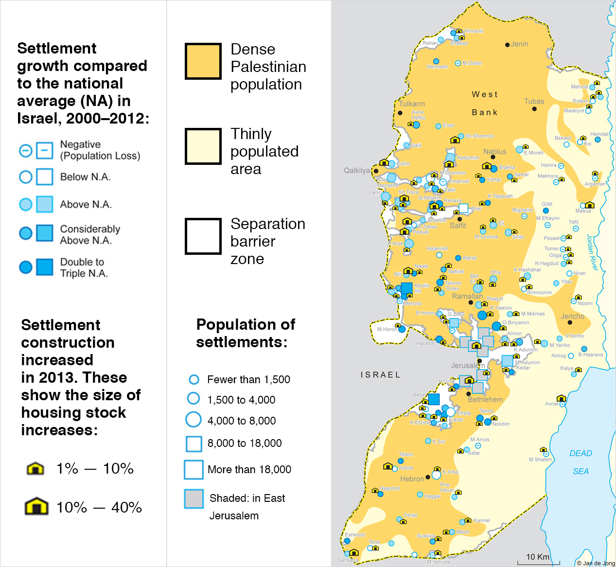
    Since 1967, Israelis have been moving into settlements in the West Bank. Some go for religious reasons, some because they want to claim Palestinian land for Israel, and some just because they get cheap housing from subsidies. There about 500,000 settlers in 130 communities, which you can see in this map. The settlements make peace harder, which is sometimes the point: for Palestinians to have a state, the settlers will either to have to be removed en masse, or Palestinians would have to give up some of their land. The settlements also make life harder for Palestinians today, dividing communities and imposing onerous Israeli security. This is why the US and the rest of the world opposes Israeli settlements. But Israel is continuing to expand them anyway.

  4. Israeli and Hezbollah strikes in the 2006 Lebanon War

    Israeli and Hezbollah strikes in the 2006 Lebanon War

    BBC

    Israeli and Hezbollah strikes in the 2006 Lebanon War

    This map shows a moment in the 2006 war between Israel and Lebanon. It also shows the way that war between Israel and its enemies has changed: Israel now has the dominant military, but the fights are asymmetrical. Israel wasn’t fighting a state, but the Lebanese militant group Hezbollah. It launched many air and artillery strikes in Lebanon (shown in blue) to weaken Hezbollah, destroying much of the country’s infrastructure in the process. Israel also blockaded Lebanese waters. Hezbollah fought a guerrilla campaign against the Israeli invasion force and launched many missiles into Israeli communities. The people most hurt were regular Lebanese and Israelis, hundreds of thousands of whom were displaced by the fighting.

  5. Which countries recognize Israel, Palestine, or both

    Which countries recognize Israel, Palestine, or both

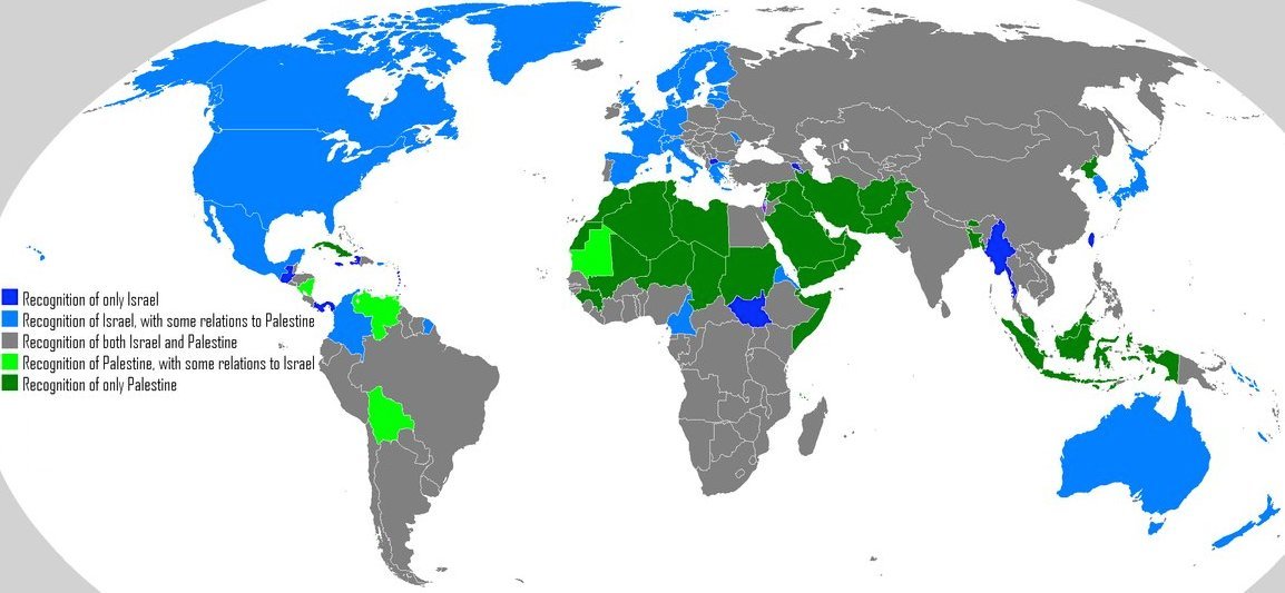
    The Israel-Palestine conflict is a global issue, and as this map shows it’s got a global divide. Many countries, shown in green, still do not recognize Israel as a legitimate state. Those countries are typically Muslim-majority (that includes Malaysia and Indonesia, way over in southeast Asia). Meanwhile, the blue countries of the West (plus a few others) do not recognize Palestine as a country. They still have diplomatic relations with Palestine, but in their view it will not achieve the status of a country until the conflict is formally resolved. It is not a coincidence that there has historically been some conflict between the blue and green countries.


Syria

  1. Syria’s religious and ethnic diversity

    Syria’s religious and ethnic diversity

    Each color here shows a different religious group in the part of the eastern Mediterranean called the Levant. It should probably not be surprising that the birthplace of Judaism and Christianity is religiously diverse, but this map drives home just how diverse. Israel stands out for its Jewish majority, of course, but this is also a reminder of its Muslim and other minorities, as well as of the Christian communities in Israel and the West Bank. Lebanon is divided among large communities of Sunnis, Shias, Christians, and a faith known as Druze — they’re at peace now, but the country’s horrific civil war from 1975 to 1990 divided them. There may be a similar effect happening in Syria, which is majority Sunni Muslim but has large minorities of Christians, Druze, Shia, and a Shia sect known as Alawites whose members include Syrian leader Bashar al-Assad and much of his government.

  2. Current areas of control in the Syrian Civil War

    Current areas of control in the Syrian Civil War

    This map shows the state of play in Syria’s civil war, which after three years of fighting has divided between government forces, the anti-government rebels who began as pro-democracy protestors, and the Islamist extremist fighters who have been moving in over the last two years. You may notice some overlap between this map and the previous: the areas under government control (in red) tend to overlap with where the minorities live. The minorities tend to be linked to the regime, whereas the rebels are mostly from the Sunni Muslim majority. But the anti-government Syrian rebels (in green) have been taking lots of territory. Syria’s ethnic Kurdish minority also has militias that have taken over territory where the Kurds live. Over the past year, though, there’s been a fourth rising faction: Islamic State of Iraq and the Levant (sometimes called ISIS, shown in blue), an extremist group based in Iraq that swears allegiance to al-Qaeda. They’re fighting both the rebels and the government. So it’s a three-way war now, as if it weren’t already intractable enough.

  3. Syria’s refugee crisis

    Syria’s refugee crisis

    Syria’s civil war hasn’t just been a national catastrophe for Syria, but for neighboring countries as well. The war has displaced millions of Syrians into the rest of the Middle East and into parts of Europe, where they live in vast refugee camps that are major drains on already-scarce national resources. This map shows the refugees; it does not show the additional 6.5 million Syrians displaced within Syria. Their impact is especially felt in Jordan and Lebanon, which already have large Palestinian refugee populations; as many as one in five people in those countries is a refugee. While the US and other countries have committed some aid for refugees, the United Nations says it’s not nearly enough to provide them with basic essentials.


Iran

  1. How Iran’s borders changed in the early 1900s

    How Iran’s borders changed in the early 1900s

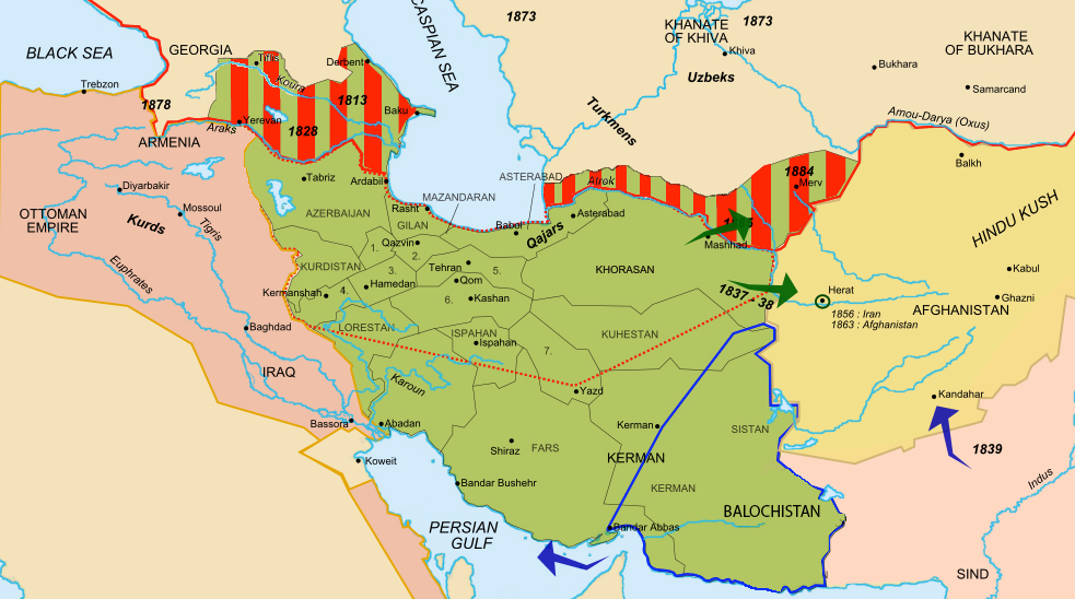
    Iran is the only Middle Eastern country was never conquered by a European power, but it came pretty close in the 1900s. It lost a lot of territory to Russia (the red stripey part). After that, the Russian Empire and British Empire (the British Indian Raj was just next door) divided Iran’s north and south into “zones of influence.” They weren’t under direct control, but the Iranian government was bullied and its economy and resources exploited. This remains a point of major national resentment in Iran today.

  2. Iran’s religious and ethnic diversity

    Iran’s religious and ethnic diversity

    Iran is most associated with the Persians — the largest ethnic group and the progenitors of the ancient Persian empires — but it’s much more diverse than that. This map shows the larger minorities, which includes Arabs in the south, Kurds in the west, and Azeris in the north (Iran used to control all Azeri territory, but much of now belongs to the Azeri-majority country Azerbaijan). The Baloch, in the southeast, are also a large minority group in Pakistan. There is significant unrest and government oppression in the “Baluchistan” region of both countries.

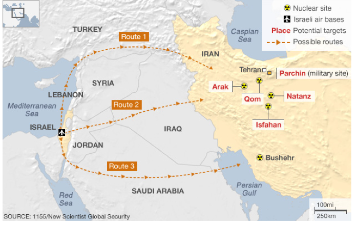
  3. Iran’s nuclear sites and possible Israeli strike plans

    Iran's nuclear sites and possible Israeli strike plans

    BBC

    Iran’s nuclear sites and possible Israeli strike plans

    This is a glimpse at two of the big, overlapping geopolitical issues in which Iran is currently embroiled. The first is Iran’s nuclear program: the country’s leaders say the program is peaceful, but basically no one believes them, and the world is heavily sanctioning Iran’s economy to try to convince them to halt the nuclear development that sure looks like it’s heading for an illegal weapons program. You can see the nuclear development sites on here: some are deep underground, while others were kept secret for years. That gets to the other thing on this map, which was originally built to show how Israel could hypothetically launch strikes against Iran’s nuclear program. Israel-Iran tensions, which have edged near war in recent years, are one of the biggest and most potentially dangerous things happening right now in a part of the world that has plenty of danger already. Israel is worried that Iran could build nukes to use against it; Iran may be worried that it will forever be under threat of Israeli strike until it has a nuclear deterrent. That’s called a security dilemma and it can get bad.


Afghanistan

  1. How the colonial “Durand Line” set up Afghanistan’s conflict

    How the colonial “Durand Line” set up Afghanistan’s conflict

    So, first ignore everything on this map except for the light-orange overlay. That shows the area where an ethnic group called the Pashtun lives. Now pretend it’s the 1800s and you are a British colonial officer named Mortimer Durand, and it’s your job to negotiate the border between the British Indian Raj and the quasi-independent nation of Afghanistan. Do you draw the border right smack across the middle of the Pashtun areas, thus guaranteeing decades of conflict by forcing Pashtuns to be minorities in both states? If you answered “yes,” then you would have made a great British colonial officer, because that’s what happened. The “Durand Line,” marked in red, became most of the border between modern Afghanistan and Pakistan. Many Pashtun now belong to or support a mostly-Pashtun extremist group called the Taliban, which wreaks havoc in both countries and has major operating bases (shown in dark orange) in the Pakistani side of the border. Thanks, Mortimer!

  2. The 1989 war that tore up Afghanistan

    The 1989 war that tore up Afghanistan

    In 1979, the Soviet Union invaded Afghanistan to defend the pro-Moscow communist government from growing rebellions. The US (along with Saudi Arabia and Pakistan) funded and armed the rebels. The CIA deliberately chose to fund extremists, seeing them as better fighters. When the Soviets retreated in 1989, those rebel groups turned against one another, fighting a horrific civil war that you can see on this map: the red areas were, as of 1989, under government control. Every other color shows a rebel group’s area of control. Some of these rebels, like the Hezb-i Islami Gulbuddin, are still fighting, though most of them were defeated when the Taliban rose up and conquered the country in the 1990s.

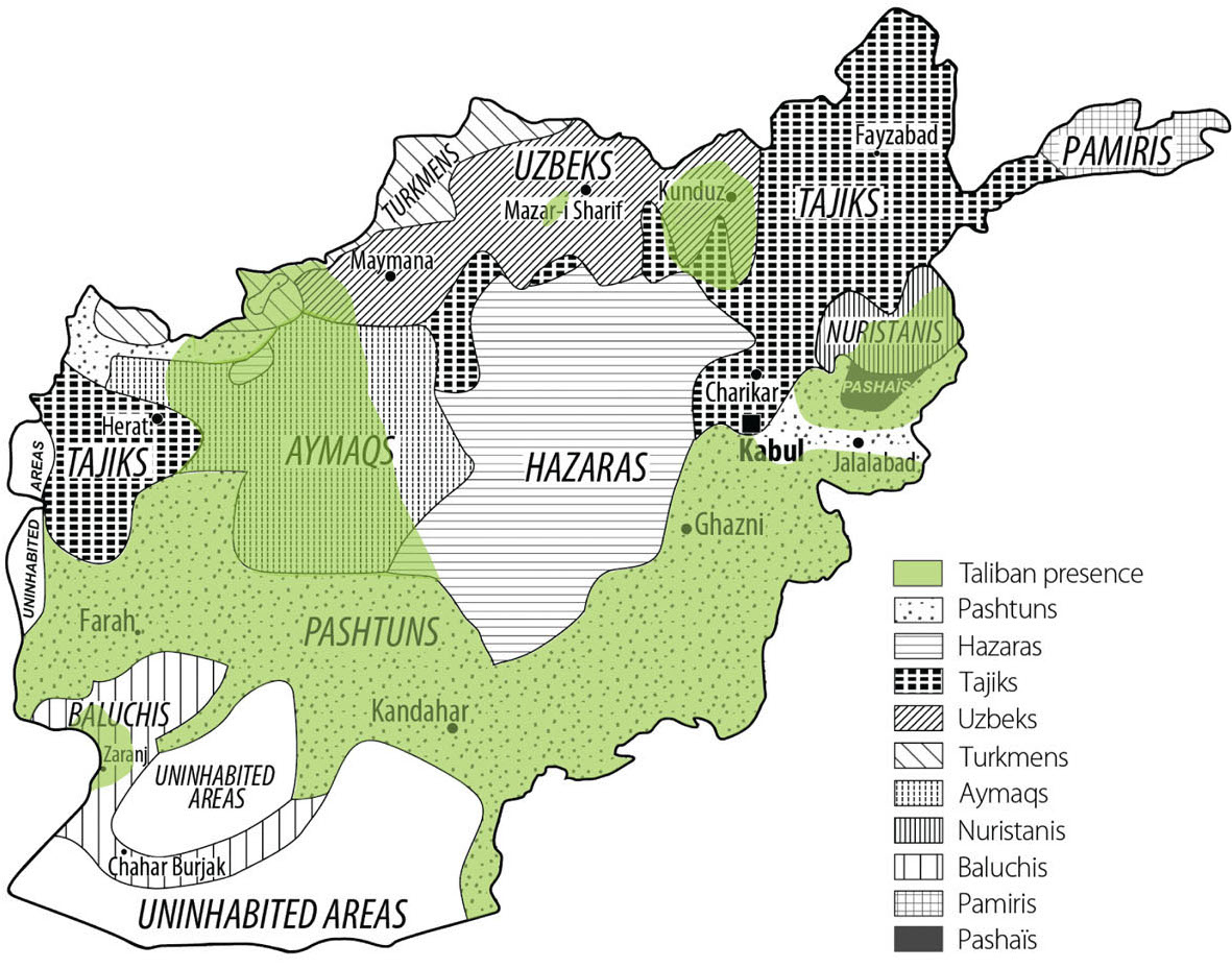
  3. How the Taliban overlaps with ethnicity

    How the Taliban overlaps with ethnicity

    This is to underscore the degree to which Afghanistan’s current war (the war that began when the US and allies invaded in 2001, not the 1979 to 1989 war against the Soviets or the civil wars from 1989 to 2001) is and is not about ethnicity. The Taliban does very broadly, but not exclusively, overlap with the Pashtuns in the south and east. That’s especially important since there are so many Pashtuns just across the border in Pakistan, where the Taliban have major bases of operation. But there are rebel groups besides the Taliban, not all of which are Pashtun. Generally, though, the north of the country is stabler and less violent than the south or east.

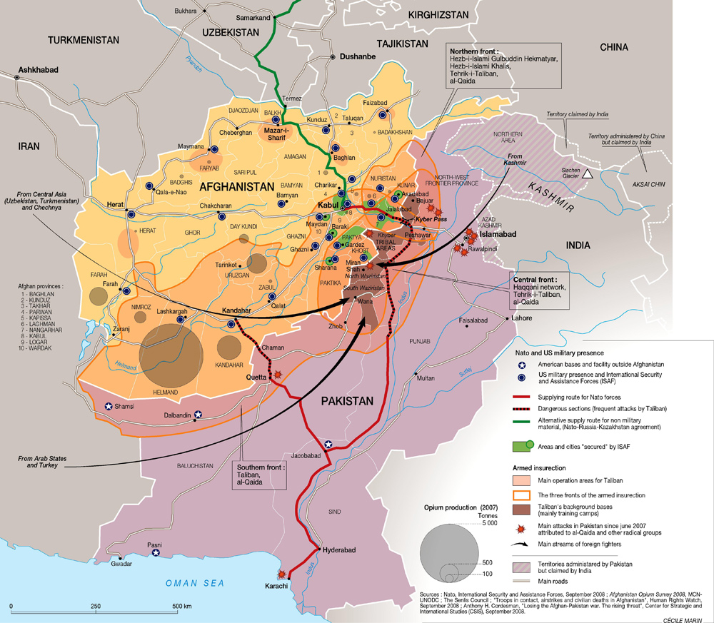
  4. The most important parts of the Afghan War, in one map

    The most important parts of the Afghan War, in one map

    The Afghanistan War is extremely complicated, but this map does a remarkable job of capturing the most important components: 1) the Taliban areas, in orange overlay; 2) the areas controlled by the US and allies, in depressingly tiny spots of green; 3) the major Western military bases, marked with blue dots; 4) the areas of opium production, which are a big source of Taliban funding, in brown circles, with larger circles meaning more opium; 5) the supply lines through Pakistan, in red, which Pakistan has occasionally shut down and come under frequent Taliban attack; 6) the supply line through Russia, which requires Russian approval. If this map does not depress you about the prospects of the Afghan War, not much will.


Saudi Arabia and Oil

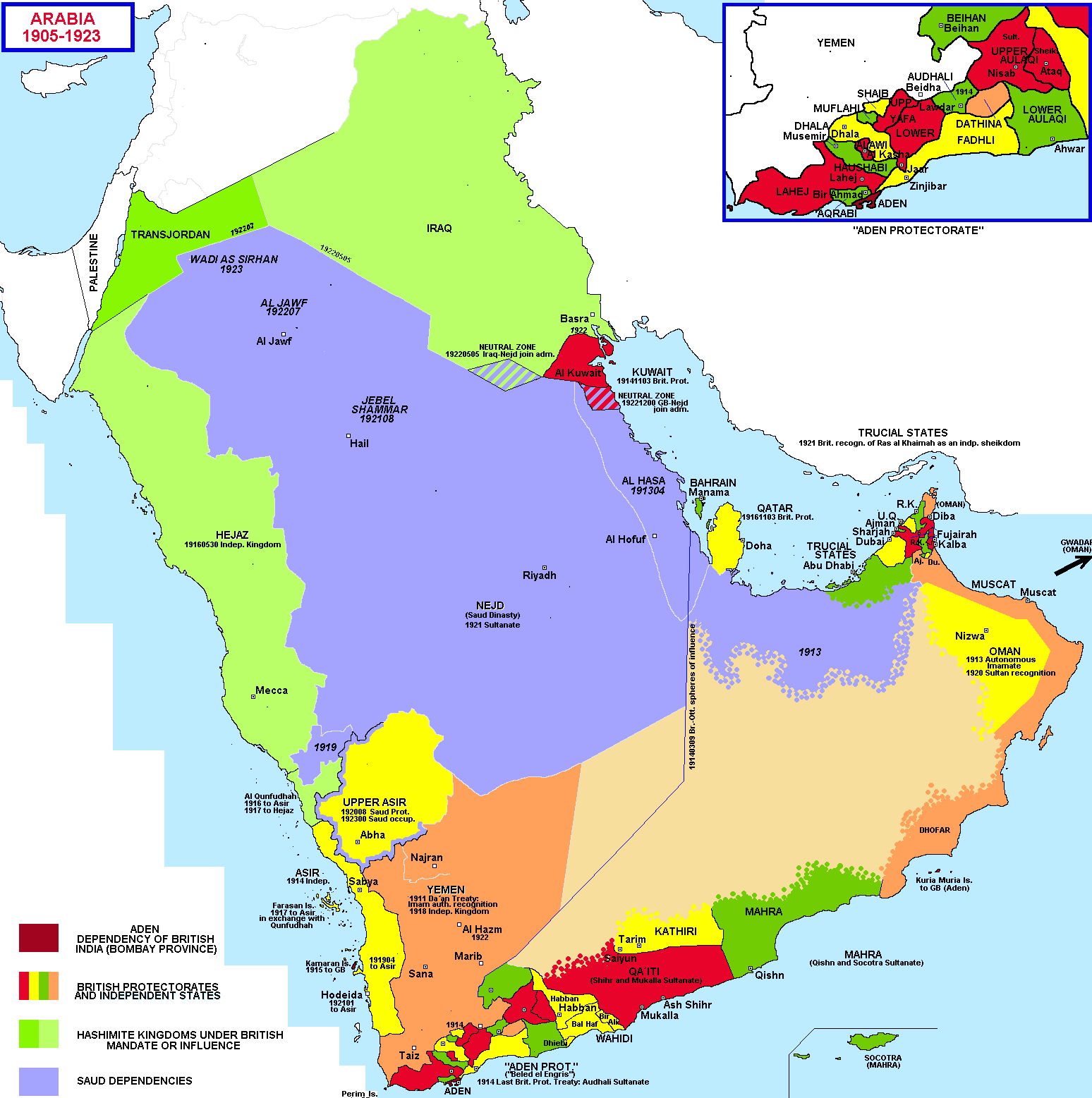
  1. What Saudi Arabia and its neighbors looked like 100 years ago

    What Saudi Arabia and its neighbors looked like 100 years ago

    The Arabian peninsula has a very, very long history, and the Saudi family has controlled much of it since the 1700s. But to understand how the peninsula got to be what it is today, go back about a 100 years to 1905. The Saudis at that point controlled very little, having lost their territory in a series of wars. The peninsula was divided into lots of little kingdoms and emirates. The Ottoman Empire controlled most of them, with the British Empire controlling the southernmost third or so of the peninsula — that line across the middle shows how it was divided. After World War I collapsed the Ottoman Empire, the Saudis expanded to all of the purple area marked here, as the British had promised for helping to fight the Ottomans. (This deal is dramatized in the film Lawrence of Arabia). By the early 1920s, the British effectively controlled almost all of the peninsula, which was divided into many dependencies, protectorates, and mandates. But the Saudis persisted.

  2. Oil and Gas in the Middle East

    Oil and Gas in the Middle East

    The Middle East produces about a third of the world’s oil and a tenth of its natural gas. (It has a third of all natural gas reserves, but they’re tougher to transport.) Much of that is exported. That makes the entire world economy pretty reliant on the continued flow of that gas and oil, which just happens to go through a region that has seen an awful lot of conflict in the last few decades. This map shows where the reserves are and how they’re transported overland; much of it also goes by sea through the Persian Gulf, a body of water that is also home to some of the largest reserves in the region and the world. The energy resources are heavily clustered in three neighboring countries that have historically hated one another: Iran, Iraq, and Saudi Arabia. The tension between those three is something that the United States, as a huge energy importer, has been deeply interested in for years: it sided against Iran during the Iran-Iraq war of the 1980s, against Iraq when it invaded Kuwait and threatened Saudi Arabia in the 1990s, again against Iraq with the 2003 invasion, and now is supporting Saudi Arabia in its rapidly worsening proxy war against Iran.

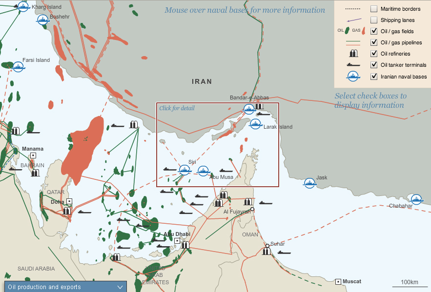
  3. Oil, trade, and militarism in the Strait of Hormuz

    Oil, trade, and militarism in the Strait of Hormuz

    The global economy depends on this narrow waterway between Iran and the Arabian Peninsula. Ever since President Jimmy Carter issued the 1980 “Carter Doctrine,” which declared that the US would use military force to defend its access to Persian Gulf oil, the little Strait of Hormuz at the Gulf’s exit has been some of the most heavily militarized water on earth. The US installed a large naval force, first to protect oil exports from the brutal Iran-Iraq War of the 1980s, then to protect them from Saddam Hussein in the 1990s Gulf Wars, and now to protect them again from Iran, which has gestured toward shutting down oil should war break out against Israel or the US. As long as the world runs on fossil fuels and there is tension in the Middle East, there will be military forces in the Strait of Hormuz.

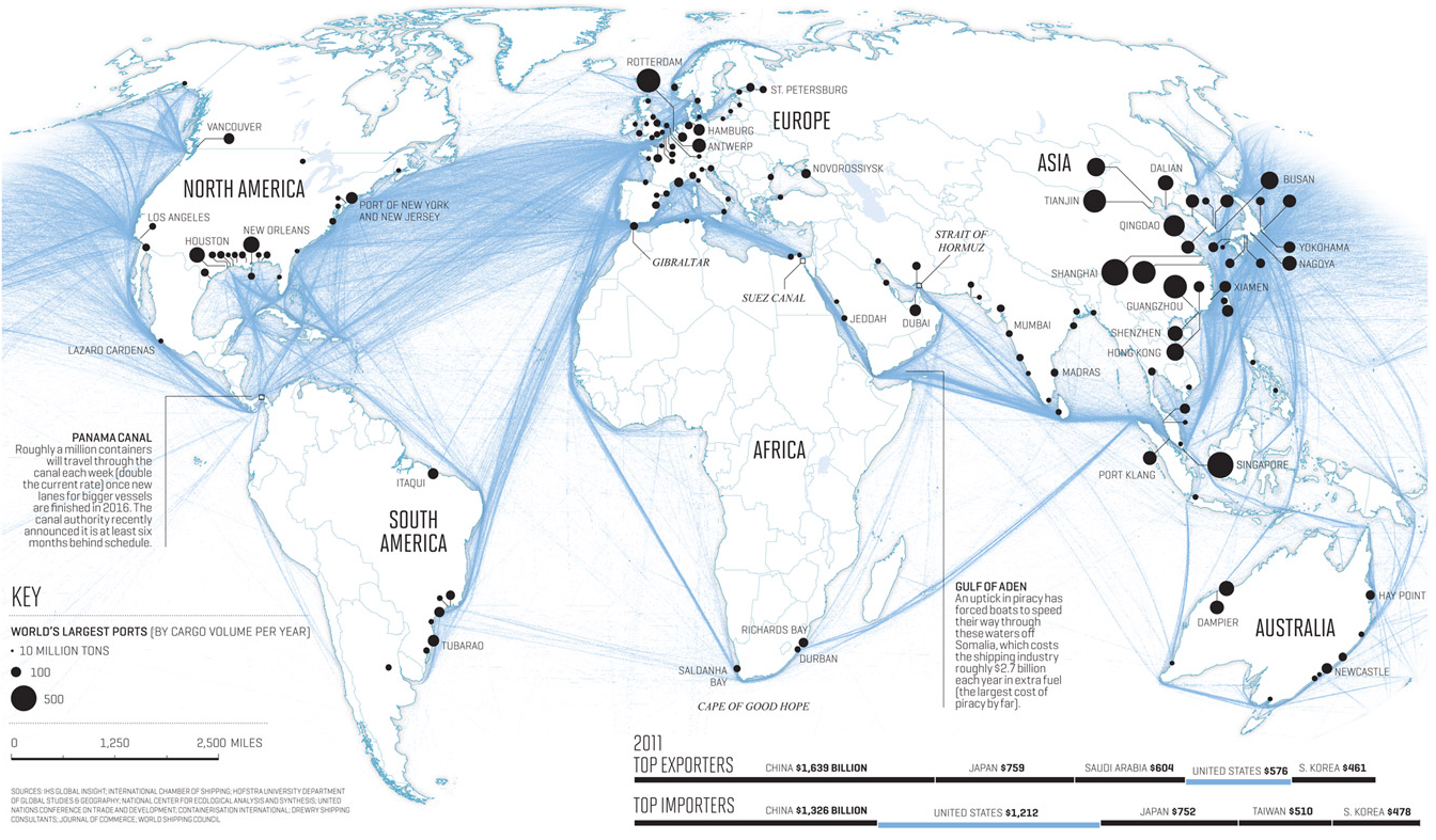
  4. Why Egypt’s Suez Canal is so important for the world economy

    Why Egypt’s Suez Canal is so important for the world economy

    The Suez Canal changed everything. When Egypt opened it in 1868, after ten years of work, the 100-mile, man-made waterway brought Europe and Asia dramatically and permanently closer. The canal’s significance to the global order was so immediately obvious that, shortly after the British conquered Egypt in the 1880s, the major world powers signed a treaty, which is still in force, declaring that the canal would forever be open to trade and warships of every nation, no matter what. Today, about eight percent of all global trade and three percent of global energy supply goes through the canal.


Iraq and Libya

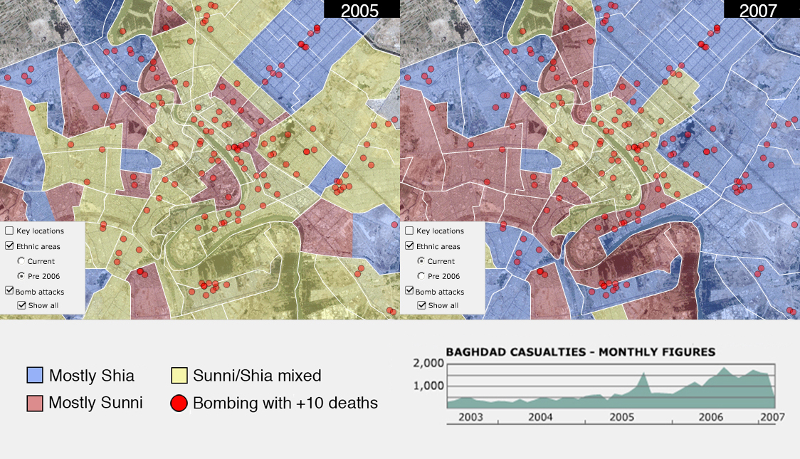
  1. The ethnic cleansing of Baghdad during the Iraq War

    The ethnic cleansing of Baghdad during the Iraq War

    BBC

    The ethnic cleansing of Baghdad during the Iraq War

    There are few grimmer symbols for the devastation of the Iraq War than what it did to Baghdad’s once-diverse neighborhoods. The map on the left shows the city’s religious make-up in 2005. Mixed neighborhoods, then the norm, are in yellow. The map on right shows what it looked like by 2007, after two awful years of Sunni-Shia killing: bombings (shown with red dots), death squads, and militias. Coerced evictions and thousands of deaths effectively cleansed neighborhoods, to be mostly Shia (blue) or mostly Sunni (red). Since late 2012, the sectarian civil war has ramped back up, in Baghdad and nationwide.

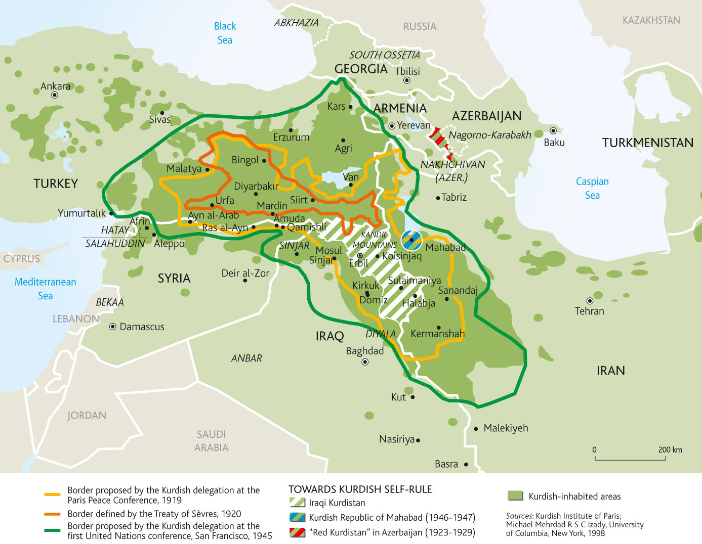
  2. Where the Kurds are and what Kurdistan might look like

    Where the Kurds are and what Kurdistan might look like

    The ethnic group known as Kurds, who have long lived as a disadvantaged minority in several Middle Eastern countries, have been fighting for a nation of their own for a long time. This map shows where they live in green overlay, and the national borders that they have proposed on three separate occasions, all of them failed. The Kurds have fought many armed rebellions, including ongoing campaigns in Syria and Turkey, and suffered many abuses, from attempted genocides to official bans on their language and culture. Their one major victory in the last century has been in Iraq: as a result of the US-led invasion that toppled Saddam Hussein, Iraqi Kurds have autonomous self-rule in Iraq’s north.

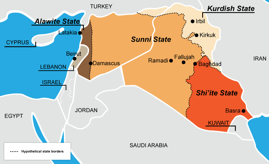
  3. A hypothetical re-drawing of Syria and Iraq

    A hypothetical re-drawing of Syria and Iraq

    This is an old idea that gets new attention every few years, when violence between Sunnis and Shias reignites: should the arbitrary borders imposed by European powers be replaced with new borders along the region’s ever-fractious religious divide? The idea is unworkable in reality and would probably just create new problems. But, in a sense, this is already what the region looks like. The Iraqi government controls the country’s Shia-majority east, but Sunni Islamist extremists have seized much of western Iraq and eastern Syria. The Shia-dominated Syrian government, meanwhile, mostly only controls the country’s Shia- and Christian-heavy west. The Kurds, meanwhile, are legally autonomous in Iraq and functionally so in Syria. This map, then, is not so much just idle speculation anymore; it’s something that Iraqis and Syrians are creating themselves.

  4. How Libya’s 2011 War changed Africa

    How Libya’s 2011 War changed Africa

    Noble as the cause was, the destruction of Moammar Qaddafi’s dictatorship by a spontaneous uprising and a Western intervention has just wreaked havoc in Africa’s northern half. This map attempts to show all that came after Qaddafi’s fall; that it is so overwhelmingly complex is precisely the point. The place to center your gaze is the patterned orange overlay across Libya, Algeria, Mali, and Niger: this shows where the Tuaregs, a semi-nomadic ethnic minority group, lives. Qaddafi used Libya’s oil wealth to train, arm, and fund large numbers of Tuaregs to fight the armed uprising in 2011. When he fell, the Tuaregs took the guns back out with them to Algeria and Mali, where they took control of territory. In Mali, they led a full-fledged rebellion that, for a time, seized the country’s northern half. Al-Qaeda moved into the vacuum they left, conquering entire towns in Mali and seizing fossil fuel facilities in Algeria. Criminal enterprises have flourished in this semi-arid belt of land known as the Sahel. So have vast migration routes, of Africans looking to find work and a better life in Europe. At the same time, armed conflict is getting worse in Nigeria and Sudan, both major oil producers. Qaddafi’s fall was far from the sole cause of all of this, but it brought just the right combination of disorder, guns, and militias to make everything a lot worse.


Points of Light

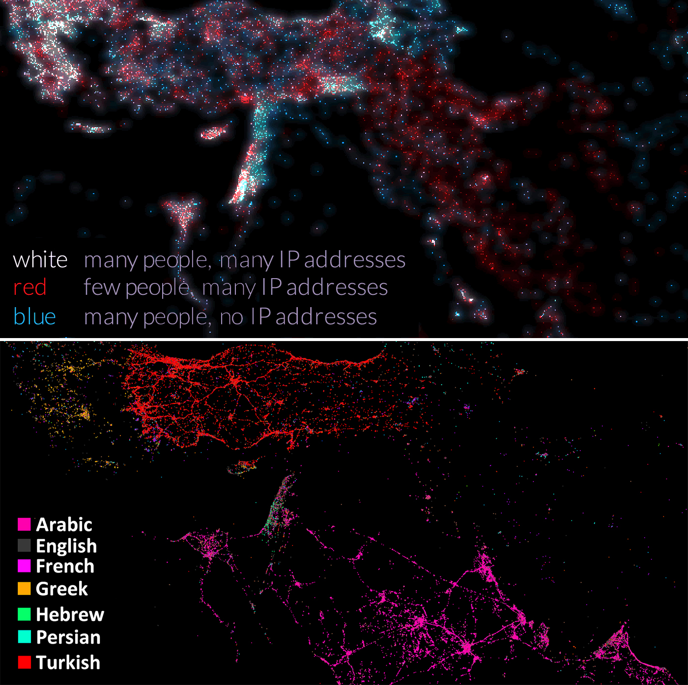
  1. Mapped by Internet connections (top) and by tweets (bottom)

    Mapped by Internet connections (top) and by tweets (bottom)

    Top map: Gregor Aisch; bottom map: Eric Fischer

    Mapped by Internet connections (top) and by tweets (bottom)

    These maps are two ways of looking at a similar thing: the digitalization of the Middle East. The map on top is actually a population map: the dots represent clusters of people, but the dots are colored to show how many IP addresses there are, which basically means how many internet connections. The blue areas have lots of people but few connections: these are the poorer areas, such as Yemen, Pakistan, and Syria. White and red show where there are lots of connections: rich countries like Israel and the United Arab Emirates, but also parts of Egypt and Iran and Turkey, the populations of which are increasingly wired, to tremendous political consequence. The map on the bottom shows tweets: lots of dots mean lots of tweets from that area. They’re colored by language. Notice where these two maps are different: Iran has lots of internet connections but almost no tweets; like Facebook, Twitter has been banned since the 2009 anti-government protests. Saudi Arabia, on the other hand, lights right up: its modestly sized population is remarkably wired. The significance of that became clear, for example, with the 2012 and 2013 social media-led campaigns by Saudi women to drive en masse, in protest of the country’s ban on female drivers. The consequences of internet access and lack of access will surely continue to be important, and perhaps hard to predict, for the region.

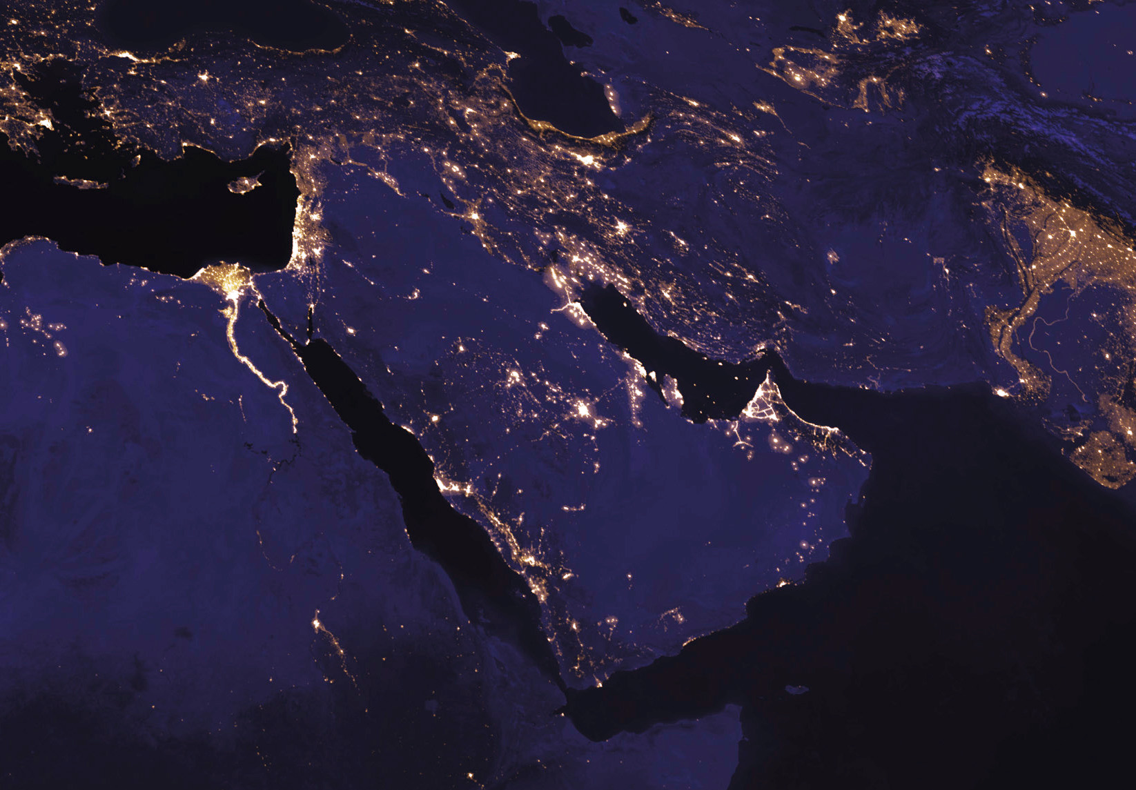
  2. The Middle East at night from space

    The Middle East at night from space

    I’m concluding with this map to look at the region without political borders, without demographic demarcations of religion or ethnicity, without markers of conflict or oil. Looking at the region at night, from space, lets those distinctions fall away, to see it purely by its geography and illuminated by the people who call it home. The lights trace the rivers that have been so important to the Middle East’s history, and the world’s: the Nile in Egypt, the Tigris and Euphrates that run through Iraq and Syria, the Indus in Pakistan. They also show the large, and in many cases growing, communities along the shores of the Persian Gulf, the eastern Mediterranean, and the southern end of the Caspian. It’s a beautiful view of a really beautiful part of the world.

Contentious House Hearing on Iran Deal/Ben Rhodes

The disdain the White House has for Republicans in Congress has a long history, but his week concerning the NYT’s interview with White House deputy security council advisor Ben Rhodes, Josh Earnest took the nastiness to a new level.

Must watch Gowdy above.

So, the hearing was held without Ben Rhodes as the White House lawyer gave Rhodes executive privilege.

Meanwhile, the Democrats in the hearing based their rhetoric and questions not on the subject at hand and the reason for the hearing but rather they all went on the collective attack of the witnesses over why the United States went into a war over a false claim on WMD.

Democrats turn Iran hearing into debate over Iraq invasion
The Iran-Iraq showdown in the House Oversight Committee probably wasn’t what GOP Rep. Jason Chaffetz intended when he arranged the session. And while Republicans made several attempts to turn the focus to the current presidential administration, not the previous one, Democrats weren’t dissuaded and the hearing degenerated into a back-and-forth. More details here from Politico.

For access to the full hearing, click here. The introduction testimony of one panelist, Mr. Hannah, go here.

FNC: Republican condemnation of a top White House aide who boasted about the administration’s success selling the Iran deal to the public reached new levels on Tuesday, as several senators urged President Obama to fire him and a House committee looking into his claims went forward with its hearing – even though he didn’t show up to testify.

The House Oversight Committee hearing was called to examine White House “narratives” on the Iran deal, after top adviser Ben Rhodes was featured in a New York Times Magazine profile claiming they built an “echo chamber” to sell the plan. Chairman Jason Chaffetz, R-Utah, had called Rhodes to testify, but the White House shielded him from the appearance.

Chaffetz, at the top of the hearing Tuesday, said “there’s still a shroud of secrecy” surrounding the Iran deal and he wanted to hear from Rhodes to seek “clarity.”

“I do not doubt his talents and his knowledge,” Chaffetz said. “But the deal that had been spun up and sold to the American public, I’m not sure it was as clear as it should have been.”

He said Rhodes, in the profile, showed “disdain” for the media and foreign policy circles.

Just hours earlier, the White House officially informed Chaffetz it would not make Rhodes available to testify, citing an executive privilege-related claim. Chaffetz did not go forward with plans to keep a seat open Tuesday for Rhodes, and instead called foreign policy analysts and scholars to testify on the deal. One of them, the American Enterprise Institute’s Michael Rubin, accused Rhodes of creating a “propaganda operation.”

The committee’s top Democrat, Rep. Elijah Cummings, D-Md., slammed Republicans for the hearing, criticizing the analysts they called while noting they didn’t invite military generals who support the agreement. He said Republicans rushed to hold the hearing “without even one week’s notice.”
Rep. Trey Gowdy, R-S.C., said at least Cummings would be able to question the witnesses present. Rhodes, he said, “didn’t bother to show up.”
Meanwhile, several GOP senators have written to Obama urging him to “dismiss” Rhodes “before he further tarnishes the Office of President.”

They wrote: “While members of the Executive and Legislative branches may sometimes deeply disagree on issues of vital importance to our nation’s security and prosperity, we should all agree, for the greater good of our Republic and the citizens whom we represent, to engage in our debates in a respectful, honest, and constructive manner. Mr. Rhodes’s disrespectful, deceptive, and destructive conduct has fallen appallingly short of this standard, however. Indeed, if he had conducted himself this way in a typical place of business outside Washington, where American taxpayers work, he surely would have been already fired or asked to resign.”

The Washington Free Beacon, which first reported on the letter, said it was signed by Sens. Mark Kirk, R-Ill.; John Cornyn, R-Texas; John Barrasso, R-Wyo.; and David Perdue, R-Ga.

Sources tell Fox News that the House committee was keen for Rhodes to appear voluntarily Tuesday so they avoid the territory of a possible subpoena.

The magazine article that touched off the controversy outlined how Rhodes created a narrative of the deal coming out of the 2013 election of “moderate” Iranian President Hassan Rouhani and Iran’s subsequent “openness” and willingness to negotiate.

In fact, the story stated, the majority of the deal was hammered out in 2012, well before Rouhani’s election. However, the Rhodes narrative was politically useful to the administration as it presented them as reaching out to the moderates who wanted peace.